Category:1888 maps of New Hampshire
Jump to navigation
Jump to search
States of the United States: California · Connecticut · Florida · Georgia · Idaho · Illinois · Iowa · Kansas · Massachusetts · Michigan · Minnesota · Missouri · Montana · New Hampshire · New York · North Carolina · North Dakota · Ohio · Oregon · Pennsylvania · South Carolina · South Dakota · Tennessee · Texas · Virginia · Washington · Wisconsin · Wyoming – Washington, D.C.
| 1883 1884 1885 1886 1887 1888 1889 → |
Media in category "1888 maps of New Hampshire"
The following 12 files are in this category, out of 12 total.
-
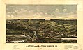
 Alton and Alton Bay, N.H. (2675802352).jpg 2,000 × 1,376; 1.86 MB
-
 Alton and Alton Bay, N.H. 1888. LOC 73694682.jpg 7,712 × 4,656; 4.91 MB
-
 Alton and Alton Bay, N.H. 1888. LOC 73694682.tif 7,712 × 4,656; 102.73 MB
-
 Berlin Falls, N.H., and Berlin Mills (2675177653).jpg 2,000 × 1,288; 2.05 MB
-
 Dover, Stafford County, New Hampshire 1888. LOC 74693164.jpg 9,792 × 7,184; 12.29 MB
-
 Dover, Stafford County, New Hampshire 1888. LOC 74693164.tif 9,792 × 7,184; 201.26 MB
-
 Gorham, N.H. (2675597664).jpg 10,189 × 8,048; 18.8 MB
-
 Gorham, N.H. 1888. LOC 73694686.jpg 8,224 × 6,400; 9.96 MB
-
 Gorham, N.H. 1888. LOC 73694686.tif 8,224 × 6,400; 150.59 MB
-
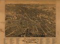
 Milton, N.H. (2675008637).jpg 2,000 × 1,283; 1.66 MB
-
 Milton, N.H., 1888 LOC 79693221.jpg 7,920 × 4,640; 5.75 MB
-
 Milton, N.H., 1888 LOC 79693221.tif 7,920 × 4,640; 105.14 MB
.jpg)

.jpg)

.jpg)

.jpg)
