Category:1886 maps of Massachusetts
Jump to navigation
Jump to search
States of the United States: California · Connecticut · Georgia · Illinois · Iowa · Kansas · Kentucky · Louisiana · Maine · Maryland · Massachusetts · Michigan · Mississippi · Missouri · Montana · New Jersey · New Mexico · New York · Ohio · Pennsylvania · Rhode Island · South Carolina · South Dakota · Tennessee · Texas · Utah · Vermont · Virginia · West Virginia · Wisconsin · Wyoming
Puerto Rico
Puerto Rico
| ← 1880 1881 1882 1883 1884 1885 1886 1887 1888 1889 → |
Media in category "1886 maps of Massachusetts"
The following 43 files are in this category, out of 43 total.
-
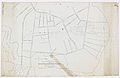 1886 Boston, Winthrop and Shore Railroad proposed branch map.jpg 5,785 × 3,744; 2.17 MB
-
 1886 Map of the Connecticut River Line and connections.jpg 7,848 × 9,517; 9.75 MB
-
 Amherst Mass1866.jpg 618 × 354; 58 KB
-
 Amherst, Mass. 1886. LOC 75694543.jpg 9,904 × 5,680; 8.44 MB
-
 Ashburnham, Mass. (2673623539).jpg 2,000 × 1,408; 1.7 MB
-
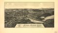
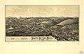
 Ayer, Mass. LOC 75694549.jpg 8,144 × 4,656; 6.71 MB
-
 Ayer, Mass. LOC 75694549.tif 8,144 × 4,656; 108.49 MB
-
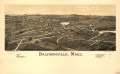
 Baldwinville, Mass. LOC 75694550.jpg 7,968 × 4,944; 6.32 MB
-
 Baldwinville, Mass. LOC 75694550.tif 7,968 × 4,944; 112.71 MB
-
 Bird's eye view map of Ayer, Massachusetts.jpg 8,397 × 5,708; 14.09 MB
-
 East Douglas, Mass. (2673638723).jpg 2,000 × 1,351; 1.79 MB
-
 East Douglas, Mass. 1886. LOC 75694567.jpg 7,888 × 4,944; 6.15 MB
-
 East Pepperell, Mass. (2674526496).jpg 2,000 × 1,455; 1.95 MB
-
 East Pepperell, Mass. 1886. LOC 75694568.jpg 6,608 × 4,944; 4.99 MB
-
 East Pepperell, Mass. 1886. LOC 75694568.tif 6,608 × 4,944; 93.47 MB
-
 Edgartown 1886 aerial map.jpg 5,723 × 3,959; 8.34 MB
-
 Edgartown, Duke's County, Martha's Vineyard Id., Mass. LOC 75694570.jpg 6,672 × 4,184; 5.53 MB
-
 Edgartown, Duke's County, Martha's Vineyard Id., Mass. LOC 75694570.tif 6,672 × 4,184; 79.87 MB
-
 Graniteville, Mass. (2674701324).jpg 2,000 × 1,441; 1.86 MB
-
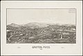
 Graniteville, Mass. 1886. LOC 75694574.jpg 8,000 × 4,624; 5.1 MB
-
 Graniteville, Mass. 1886. LOC 75694574.tif 8,000 × 4,624; 105.84 MB
-
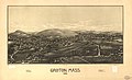
 Groton, Mass. (2673647237).jpg 2,000 × 1,366; 1.57 MB
-
 Groton, Mass. 1886. LOC 75694576.jpg 8,176 × 4,960; 6.71 MB
-
 Haydenville, Mass. (2674706216).jpg 2,000 × 1,384; 1.92 MB
-
 Haydenville, Mass. 1886. LOC 75694578.jpg 7,120 × 4,800; 5.42 MB
-
 Haydenville, Mass. 1886. LOC 75694578.tif 7,120 × 4,800; 97.78 MB
-
 Huntington, Mass. (2674477708).jpg 2,000 × 1,400; 1.73 MB
-
 Huntington, Mass. 1886. LOC 75694585.jpg 6,608 × 4,544; 4.36 MB
-
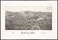
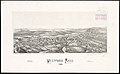
 Leominster, Mass. (2674542750).jpg 2,000 × 1,329; 2.22 MB
-
 Leominster, Mass. 1886. LOC 75694586.jpg 9,328 × 5,312; 8.36 MB
-
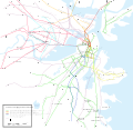 Map of Boston Horsecar Lines 1886.svg 2,289 × 2,232; 399 KB
-
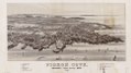
 Pigeon Cove, Rockport, Essex County, Mass., 1886 LOC 2005628432.jpg 7,993 × 4,545; 5.01 MB
-
 Pigeon Cove, Rockport, Essex County, Mass., 1886 LOC 2005628432.tif 7,993 × 4,545; 103.94 MB
-
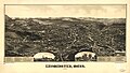
 South Acton, Mass. (2674436396).jpg 2,000 × 1,414; 1.71 MB
-
 South Acton, Mass. 1886. LOC 75694602.jpg 7,360 × 4,688; 4.61 MB
-
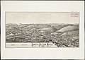
 The Farms. 1886. LOC 75694890.jpg 9,648 × 5,568; 9.69 MB
-
 The Farms. 1886. LOC 75694890.tif 9,648 × 5,568; 153.69 MB
-
 Txu-pclmaps-topo-ma-salem-1886.jpg 2,941 × 3,556; 3.6 MB
-
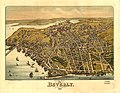 View of Beverly, Massachusetts, 1886. LOC 74693250.jpg 8,336 × 6,464; 8.12 MB
-
 View of Beverly, Massachusetts, 1886. LOC 74693250.tif 8,336 × 6,464; 154.16 MB
-
 Westford, Mass. (2673880403).jpg 2,000 × 1,235; 1.4 MB
-
 Westford, Mass. 1886. LOC 75694608.jpg 6,752 × 3,856; 3.66 MB
-
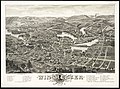 Winchester, Middlesex County, Mass. (2674709248).jpg 2,000 × 1,481; 2.79 MB


.jpg)


.jpg)

.jpg)


.jpg)

.jpg)

.jpg)

.jpg)

.jpg)


.jpg)


.jpg)

.jpg)