Category:1882 maps of Massachusetts
Jump to navigation
Jump to search
States of the United States: Florida · Kansas · Louisiana · Massachusetts · New York · Ohio · Pennsylvania · Texas · Virginia · Wyoming
| ← 1880 1881 1882 1883 1884 1885 1886 1887 1888 1889 → |
Media in category "1882 maps of Massachusetts"
The following 19 files are in this category, out of 19 total.
-
 1882 bird's-eye view map of Plymouth, Massachusetts LOC 2011589144.tif 11,707 × 9,154; 306.6 MB
-
 1882 bird's-eye view map of Plymouth, Massachusetts.jpg 11,707 × 9,154; 17.46 MB
-
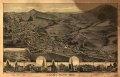
 Adams, Mass. - 1882. LOC 91680093.jpg 9,500 × 6,090; 14.1 MB
-
 Adams, Mass. - 1882. LOC 91680093.tif 9,500 × 6,090; 165.52 MB
-
 Bird's eye view map of Brockton, Massachusetts, circa 1882.jpg 9,760 × 6,544; 8.66 MB
-
 Bird's eye view of the city of Brockton, Plymouth County, Mass. 1882. LOC 76693075.jpg 12,208 × 7,728; 19.59 MB
-
 Bird's eye view of the city of Brockton, Plymouth County, Mass. 1882. LOC 76693075.tif 12,208 × 7,728; 269.92 MB
-
 Birds eye view of the town of Provincetown, Barnstable County, Mass. (2673737871).jpg 2,000 × 1,014; 1.34 MB
-

-
 Norwood station on 1882 bird's eye map.jpg 620 × 465; 79 KB
-
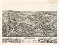 Norwood, Massachusetts. LOC 2013591356.jpg 8,213 × 6,196; 10.59 MB
-
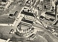
 NY&NE shops and Norwood Central station on 1882 bird's eye map.jpg 1,360 × 799; 346 KB
-
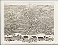
 Plymouth station on 1882 bird's-eye view map.jpg 1,223 × 885; 262 KB
-
 View of Andover, Massachusetts (2673622885).jpg 2,000 × 1,556; 2.74 MB
-
 View of Randolph, Mass. (2674529258).jpg 2,000 × 1,559; 2.63 MB
-
 View of Saxonville, Mass. (2673658967).jpg 2,000 × 1,561; 2.48 MB
-
 View of South Braintree, Massachusetts (2674451562).jpg 8,367 × 6,536; 16.76 MB
-
 View of Wakefield, Mass. (2673728615).jpg 8,383 × 6,999; 23.64 MB
-
 Walpole, Massachusetts - 1882 G3764.W18A3 1882O43.jpg 8,496 × 7,039; 14.92 MB


.jpg)


.jpg)
.jpg)
.jpg)
.jpg)
.jpg)
