Category:1880s maps of the Caribbean
Jump to navigation
Jump to search
Subcategories
This category has the following 10 subcategories, out of 10 total.
Media in category "1880s maps of the Caribbean"
The following 18 files are in this category, out of 18 total.
-

-

-

-

-
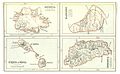 Map of Antigua, Barbados, St.Kitts and Dominica (1888).jpg 1,935 × 1,201; 1.43 MB
-
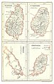 Map of St.Lucia, St. Vincent, Tobago and Grenada (1888).jpg 1,239 × 1,947; 1.54 MB
-
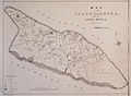
 Map of St.Vincent (1888).jpg 1,233 × 1,909; 1.25 MB
-
 Map of the Bahamas and neighbouring islands.jpg 4,344 × 3,730; 5.37 MB
-

-

-

-
 Frazier Aruba Gold Mining Co circa 1885.jpg 2,294 × 1,674; 422 KB
-

-

-
 Meyers b16 s0558b.jpg 800 × 597; 161 KB
-

-
 United States Caribbean map 1880-09-13 to 1882-06-01.png 2,000 × 1,182; 239 KB
-
 United States Caribbean map 1882-06-01 to 1884-06-21.png 2,000 × 1,182; 235 KB
.jpg)
%27_(11163392385).jpg)
%27_(11164438855).jpg)
.jpg)
.jpg)
.jpg)
.jpg)

.jpg)
.jpg)
_(14782067334).jpg)

%27.jpg)
%27_(16589744785).jpg)

_(14753014094).jpg)

