Category:1877 maps of Canada
Jump to navigation
Jump to search
| ← 1870 1871 1872 1873 1874 1875 1876 1877 1878 1879 → |
English: Maps of Canada from 1877 or related to Canada in 1877
Français : Les cartes du Canada de 1877 ou se rapportant au Canada en 1877
Media in category "1877 maps of Canada"
The following 17 files are in this category, out of 17 total.
-
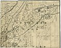
 1877 Peel Atlas pg08-09 Caledon Twp PN2019 01866-68.jpg 33,248 × 21,750; 177.95 MB
-
 1877 Peel Atlas pg36-37 Brampton PN2018 10278-81.jpg 19,504 × 30,000; 481.15 MB
-
 1877-yorkville-james.jpg 3,752 × 1,990; 1.46 MB
-
 Caribou Marsh Reserve No 29 - 1877.jpg 1,000 × 634; 117 KB
-
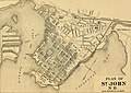 History of the great fire in Saint John, June 20 and 21, 1877 (1877) (14798298683).jpg 2,672 × 1,896; 1.1 MB
-
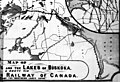
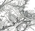 Intercolonial-1877.jpg 855 × 757; 203 KB
-
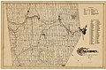
 Plan Village of Malton of the County of Peel 1877.jpg 2,769 × 4,000; 4.27 MB
-
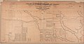
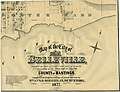
 Port Burwell 1877.jpg 1,151 × 1,976; 676 KB
-
 Sheet 1 (41672045971).jpg 7,144 × 5,625; 5.7 MB
-
 Sheet 2 (27803891048).jpg 7,293 × 5,698; 6.66 MB
-
 Sheet 3 (26805106057).jpg 7,124 × 5,722; 6.77 MB
-
 Sheet 4 (26805138527).jpg 7,216 × 5,914; 6.19 MB
-
 Sheet 5 (41672016151).jpg 7,115 × 5,686; 5.06 MB
-
 Sheet 6 (27803822258).jpg 7,375 × 5,634; 4.7 MB
-
-

-


_(14798298683).jpg)


.jpg)
.jpg)
.jpg)
.jpg)
.jpg)
.jpg)
_-_the_game_animals,_birds_and_fishes_of_North_America_-_their_habits_and_various_methods_of_capture_-_copious_instructions_in_shooting,_fishing,_(19991893813).jpg)
_-_the_game_animals,_birds_and_fishes_of_North_America_-_their_habits_and_various_methods_of_capture_-_copious_instructions_in_shooting,_fishing,_(20586493426).jpg)
.jpg)