
Category:1870s maps of Boston
Most populous urban areas of the world: Boston [US] · Chicago [US] · Istanbul [TR] · London [GB] · New York City [US] · Paris [FR] · Philadelphia [US] · Toronto [CA] · Washington, D.C. [US]
- 100 most populous cities of the United States
- 1–25
- Boston
- Chicago
- Denver
- New York City
- Philadelphia
- Washington, D.C.
- 26–50
- Baltimore
- 51–75
- New Orleans
- 76–100
State capitals of the United States: Boston [MA] · Denver [CO] · Federal district: Washington, D.C. [DC] · Insular area of the United States
Subcategories
This category has the following 4 subcategories, out of 4 total.
Media in category "1870s maps of Boston"
The following 42 files are in this category, out of 42 total.
-
 1870 Macullar Parker HawleySt Boston.png 479 × 538; 390 KB
-

-

-
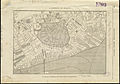
 Plan of Boston, with additions and corrections (2675370598).jpg 2,000 × 1,331; 2.45 MB
-
 Plan of estate... (2674559175).jpg 1,220 × 2,000; 1.74 MB
-

-
 Plan of Grays Wharf... (2675373362).jpg 997 × 2,000; 1.33 MB
-
 1871 Boston map by H. F. Walling & Orm Gray.jpg 8,552 × 5,531; 14.07 MB
-
 Boston Street Map, 1871.jpg 4,976 × 3,311; 7.52 MB
-
 New map of Boston (2674727431).jpg 2,000 × 1,510; 2.91 MB
-
 Plan no II of land of George D. Welles situated in ward 16 Boston (2675511768).jpg 2,000 × 1,276; 1.55 MB
-

-

-
 Map of Boston 1872 (7557398876).jpg 6,718 × 4,494; 28.59 MB
-
 Plan of house lots in Boston belonging to Otis H. Weed (3120133737).jpg 2,000 × 1,089; 1.59 MB
-

-

-

-
 Plan of the town of West Roxbury (2674681845).jpg 2,000 × 1,477; 2 MB
-
 Trustees sale (2675500384).jpg 1,398 × 2,000; 1.88 MB
-
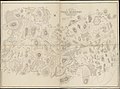
 146 of 'Cassell's History of the United States ... Illustrated' (11104130714).jpg 1,762 × 2,385; 1.06 MB
-
 Beers' fire insurance district map of the city of Boston. LOC 77691673.jpg 12,580 × 9,097; 16.45 MB
-
 Beers' fire insurance district map of the city of Boston. LOC 77691673.tif 12,580 × 9,097; 327.42 MB
-

-
 Map of Boston, showing the new wards (3856484788).jpg 1,841 × 2,000; 2.8 MB
-
 1876 chart of Jamaica Pond and plan of surroundings.jpg 6,251 × 5,683; 3.83 MB
-
 1876 plan for West Roxbury Park.jpg 8,376 × 7,840; 5.97 MB
-
 Jamaica Park and Bussey Farm Parkway (2675499634).jpg 2,000 × 1,442; 2.01 MB
-
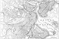 EB9 Boston.jpg 2,559 × 1,681; 961 KB
-

-
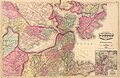
 1879 Mitchell Map of Boston, Massachusetts - Geographicus - Boston-mitchell-1879.jpg 4,000 × 2,620; 3.91 MB
-
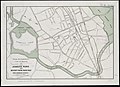
 1879 plan of Arnold Arboretum.jpg 4,708 × 3,732; 1.46 MB
-

-
 Map of central Boston with all the Railroad Stations - 1879 B&M text.jpg 1,136 × 2,108; 1.13 MB
-
 Plan of Charlestown (2674621825).jpg 2,000 × 1,391; 2.26 MB
-
 Plan of real estate belonging to T.W. & J.H. Cox (2675506334).jpg 2,000 × 1,309; 1.58 MB
-
-

-
 Gen. Washingtons Revolutionary campaign war map (2675083506).jpg 2,000 × 1,472; 2.78 MB
-
-
 Plan of Boston (2675621194).jpg 2,000 × 1,336; 2.78 MB
-
 Plan of house lots in ward 16 (2675505590).jpg 2,000 × 1,433; 1.7 MB


.jpg)
.jpg)
.jpg)
.jpg)


.jpg)
.jpg)
.jpg)
_(3369693159).jpg)
.jpg)
.jpg)
,_by_Thos._W._Davis,_city_surveyor,_from_the_Digital_Commonwealth_-_commonw.jpg)
.jpg)
.jpg)
.jpg)
.jpg)
.jpg)

.jpg)
.jpg)


.jpg)

.jpg)


.jpg)
.jpg)
_belonging_to_B.P._Cunningham_(2674684813).jpg)
.jpg)
.jpg)
.jpg)
.jpg)
.jpg)