
Category:1820s maps of the Netherlands
Provinces of the Netherlands:
Media in category "1820s maps of the Netherlands"
The following 15 files are in this category, out of 15 total.
-
 Topnl1820k002.jpg 3,360 × 2,640; 1.29 MB
-
 Heerlen in 1825.jpg 1,777 × 2,066; 1.08 MB
-

-

-

-

-
 1827 Carte routière du Royaume des Pays-Bas, comprenant la Hollande et la Belgique.pdf 1,239 × 1,752, 2 pages; 3.02 MB
-
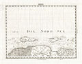
 1827 Finley Map of Holland or the Netherlands - Geographicus - Holland-finley-1827.jpg 3,000 × 2,383; 1.89 MB
-

-

-
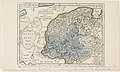
 Graafschap Zutphen 1823.png 1,804 × 1,415; 2.5 MB
-
 Kaart NH 4 februari 1825 01.jpg 4,652 × 6,335; 4.83 MB
-

-
-
 Te Rotterdam by Arbon en Krap 1825 (BM 1855,0414.282).jpg 2,500 × 1,734; 560 KB


.jpg)
.jpg)

_(14595259400).jpg)


_Vijf_kaarte,_RP-P-OB-87.463.jpg)
.jpg)