Category:1820s maps of Eastern Europe
Jump to navigation
Jump to search
| 19th-century maps of Eastern Europe: ← 1800s 1810s 1820s 1830s 1840s 1850s 1860s 1870s 1880s 1890s → |
Media in category "1820s maps of Eastern Europe"
The following 4 files are in this category, out of 4 total.
-

-
 Bulletin de l'Acadmie impriale des sciences de St.-Ptersbourg (19810211213).jpg 906 × 1,028; 180 KB
-
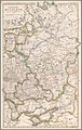 Russian Empire - European part, 1825.jpg 5,722 × 9,000; 13.32 MB
-
 Osteuropa BV023236953.jpg 6,882 × 4,403; 2.87 MB
.jpg)

