Category:17th-century maps of Scotland
Jump to navigation
Jump to search
Subcategories
This category has the following 8 subcategories, out of 8 total.
- 1600s maps of Scotland (empty)
- 1620s maps of Scotland (5 F)
- 1640s maps of Scotland (4 F)
- 1680s maps of Scotland (3 F)
- 1690s maps of Scotland (5 F)
S
Media in category "17th-century maps of Scotland"
The following 11 files are in this category, out of 11 total.
-

-
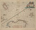 1663 map Pieter Goos northsea norwegian sea.jpg 6,950 × 5,989; 4.1 MB
-
 Scotiae provintiae inter Taum fluvium et septentrionales oras Angliae - CBT 6590013.jpg 5,807 × 4,760; 8.02 MB
-
 17th Century Map of Teviotdale, Roxburghshire, Scotland.png 568 × 454; 502 KB
-

-

-
 Lorna, Knapdalia, Cantire, Iura, Ila, Glota et Buthe insulae - CBT 6590546.jpg 5,820 × 4,760; 6.96 MB
-
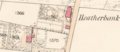 OSHeatherbank.png 1,173 × 505; 946 KB
-
 Part of a map of Aberdeen in 1661. Wellcome M0008083.jpg 2,958 × 4,026; 3.97 MB
-
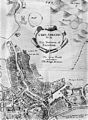
 Plan of Edinburgh showing the Town's College, marled W, 1647. Wellcome M0012085.jpg 3,659 × 3,004; 5.73 MB
-
 Provincae Lauden seu Lothien et Linlitouo - CBT 6604748.jpg 6,072 × 4,324; 6.77 MB
.jpg)


_Pont,_de_R._Gordon_a_Straloch_and_c_;_Par_le_Sr_Sanson_d%27Abbev(ille)_Geogr(aphe)_ord(inai)re_du_Roy_-_btv1b530568070.jpg)
_Geogr(aphe)_ord(inai)re..._-_btv1b530562693.jpg)


