
Category:1790s maps of Hesse
Federal states of Germany:
Subcategories
This category has the following 3 subcategories, out of 3 total.
- 1791 maps of Hesse (1 F)
- 1795 maps of Hesse (1 F)
- 1799 maps of Hesse (empty)
Media in category "1790s maps of Hesse"
The following 15 files are in this category, out of 15 total.
-
 1790 Hoeck Karte Oberisenburg.png 1,092 × 788; 1.18 MB
-
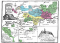
 Reilly 224.jpg 1,340 × 847; 501 KB
-

-
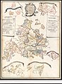 Einteilung des Ober- und Niederfürstentums Hessens.jpg 2,215 × 3,000; 1.28 MB
-

-

-

-

-

-

-

-

-

-

-


_Bl%C3%A4ttern_von_den_L%C3%A4ndern_zwischen_dem_Rhein_Main_und_Neckar_nebst_den_angr%C3%A4nzenden_Gegenden_-_Anordnung_zu_HK1143-1156.jpg)
_Bl%C3%A4ttern_von_den_L%C3%A4ndern_zwischen_dem_Rhein_Main_und_Neckar_nebst_den_angr%C3%A4nzenden_Gegenden_-_HK1143.jpg)
_Bl%C3%A4ttern_von_den_L%C3%A4ndern_zwischen_dem_Rhein_Main_und_Neckar_nebst_den_angr%C3%A4nzenden_Gegenden_-_HK1144.jpg)
_Bl%C3%A4ttern_von_den_L%C3%A4ndern_zwischen_dem_Rhein_Main_und_Neckar_nebst_den_angr%C3%A4nzenden_Gegenden_-_HK1145.jpg)
_Bl%C3%A4ttern_von_den_L%C3%A4ndern_zwischen_dem_Rhein_Main_und_Neckar_nebst_den_angr%C3%A4nzenden_Gegenden_-_HK1146.jpg)
_Bl%C3%A4ttern_von_den_L%C3%A4ndern_zwischen_dem_Rhein_Main_und_Neckar_nebst_den_angr%C3%A4nzenden_Gegenden_-_HK1147.jpg)
_Bl%C3%A4ttern_von_den_L%C3%A4ndern_zwischen_dem_Rhein_Main_und_Neckar_nebst_den_angr%C3%A4nzenden_Gegenden_-_HK1148.jpg)
_Bl%C3%A4ttern_von_den_L%C3%A4ndern_zwischen_dem_Rhein_Main_und_Neckar_nebst_den_angr%C3%A4nzenden_Gegenden_-_HK1150.jpg)
_Bl%C3%A4ttern_von_den_L%C3%A4ndern_zwischen_dem_Rhein_Main_und_Neckar_nebst_den_angr%C3%A4nzenden_Gegenden_-_HK1152.jpg)
_Bl%C3%A4ttern_von_den_L%C3%A4ndern_zwischen_dem_Rhein_Main_und_Neckar_nebst_den_angr%C3%A4nzenden_Gegenden_-_HK1155.jpg)
_Bl%C3%A4ttern_von_den_L%C3%A4ndern_zwischen_dem_Rhein_Main_und_Neckar_nebst_den_angr%C3%A4nzenden_Gegenden_-_HK1156.jpg)