Category:1782 maps of the United States
Jump to navigation
Jump to search
Subcategories
This category has the following 3 subcategories, out of 3 total.
Media in category "1782 maps of the United States"
The following 11 files are in this category, out of 11 total.
-
 1782 Map of the island of Nantucket by Crèvecoeur BPL n48579.png 933 × 685; 1.1 MB
-
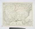
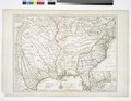
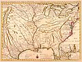
 Carte de la Louisiane et du cours du Mississipi, avec les colonies anglaises.jpg 3,771 × 2,837; 2.21 MB
-
 Carte de la Virginie, du Maryland et de letat de Delaware (4578767503).jpg 4,748 × 3,164; 6.3 MB
-

-

-
 Côte de York-town à Boston- Marches de l'armée. LOC gm71002181.jpg 19,636 × 5,586; 13.3 MB
-
-
-

-
-
 Carte de la Virginie, du Maryland et de l'etat de Delaware (NYPL b15317660-976260).jpg 5,891 × 4,272; 4.47 MB


.jpg)
.jpg)
.jpg)
.jpg)
.jpg)
.jpg)