Category:1777 maps of New York (state)
Jump to navigation
Jump to search
States of the United States: Connecticut · Delaware · Maine · Maryland · Massachusetts · Mississippi · New Hampshire · New Jersey · New York · North Carolina · Pennsylvania · Rhode Island · South Carolina · Vermont · Virginia
Subcategories
This category has the following 5 subcategories, out of 5 total.
Media in category "1777 maps of New York (state)"
The following 34 files are in this category, out of 34 total.
-

-

-

-
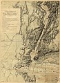
 (Part of a map of the Hudson Highlands showing Forts Clinton and Montgomery. LOC gm71002330.tif 5,504 × 7,615; 119.91 MB
-

-

-
 A topographical map of the northn. part of New York Island... (2674343553).jpg 1,371 × 2,000; 2.23 MB
-
 BattleOfFortWashingtonMapBySauthier.jpg 2,528 × 4,595; 4.79 MB
-
 Forts Washington Tryon Cockhill.jpg 1,356 × 1,798; 1.13 MB
-
-

-
-

-

-

-

-

-

-
 Albany County 1777.png 2,139 × 1,743; 5.86 MB
-

-
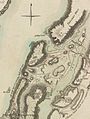
 BattleOfFortsClintonAndMontgomery1777.jpg 4,132 × 2,212; 2.42 MB
-
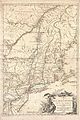
 ChamplainValley1777.jpg 632 × 1,980; 641 KB
-
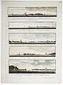 Five views of New York and approaches RMG K0864.jpg 947 × 1,280; 820 KB
-
 HudsonValley1777.jpg 360 × 1,470; 249 KB
-
 Livingston Manor 1777.png 314 × 249; 189 KB
-
 NorthernNewJersey1777.jpg 1,628 × 1,072; 918 KB
-

-
 Province de New-York en 4 feuilles, LOC 74692642.jpg 11,794 × 17,650; 33.21 MB
-

-

-

-

-

-


_with_a_view_of_the_engagement_on_the_Hudson_river_on_16_August_1776.)_RMG_K0372.jpg)
_with_a_view_of_the_engagement_on_the_Hudson_river_on_16_August_1776.)_RMG_K0373.jpg)
.jpg)


_-_Geographicus_-_TheatredelaGeurre-briondelatour-1777.jpg)


