Category:1760s maps of Pennsylvania
Jump to navigation
Jump to search
States of the United States: Alabama · Alaska · California · Connecticut · Florida · Georgia · Louisiana · Maine · Massachusetts · Mississippi · New Hampshire · New Jersey · New York · North Carolina · Ohio · Pennsylvania · South Carolina · Tennessee · Vermont · Virginia
Puerto Rico
Puerto Rico
Subcategories
This category has the following 7 subcategories, out of 7 total.
- 1760 maps of Pennsylvania (2 F)
- 1761 maps of Pennsylvania (1 F)
- 1765 maps of Pennsylvania (1 F)
- 1766 maps of Pennsylvania (1 F)
- 1768 maps of Pennsylvania (3 F)
P
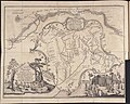
Media in category "1760s maps of Pennsylvania"
The following 5 files are in this category, out of 5 total.
-
-
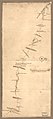
 Ohio river 1766.png 3,717 × 1,867; 9.88 MB
-

-
-
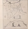
 Thomas Hutchins Map of Henry Bouquet's 1764 Expedition.jpg 9,706 × 7,739; 20.11 MB


.jpg)
.jpg)
