Category:1760s maps of North Carolina
Jump to navigation
Jump to search
States of the United States: Alabama · Alaska · California · Connecticut · Delaware · Florida · Georgia · Louisiana · Maine · Maryland · Massachusetts · Mississippi · New Hampshire · New Jersey · New York · North Carolina · Ohio · Pennsylvania · South Carolina · Tennessee · Vermont · Virginia
Puerto Rico
Puerto Rico
Media in category "1760s maps of North Carolina"
This category contains only the following file.
-
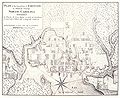 Map of Edenton Chowan County North Carolina 1769.jpg 1,935 × 1,581; 784 KB
