Category:1760s maps of Paris
Jump to navigation
Jump to search
Subcategories
This category has the following 6 subcategories, out of 6 total.
Media in category "1760s maps of Paris"
The following 11 files are in this category, out of 11 total.
-
 1762 map of the surroundings of Paris.jpg 6,080 × 4,268; 6.18 MB
-
 Plan de Paris et de ses Faubourgs en l'etat qu'il etoit en 1765 (BM 1861,1012.3).jpg 2,500 × 1,909; 1.43 MB
-
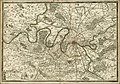
 Environs de Paris Vaugondy 1761 jms.jpg 8,192 × 6,722; 17.85 MB
-
 Jean Lattré, Plan de la ville de Paris et de ses Faubourgs, 1765 - Gallica.jpg 9,696 × 6,912; 13.94 MB
-
 Jean-Baptiste Nolin, Plan routier de la ville et faubourg de Paris, 1761 - Gallica.jpg 10,596 × 7,997; 15.97 MB
-
 Karta över Paris indelat i 20 distrikt, tryckt 1763 - Skoklosters slott - 86164.tif 3,093 × 2,668, 2 pages; 18.05 MB
-
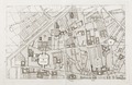 Karta över Paris indelat i 20 distrikt, tryckt 1763 - Skoklosters slott - 86165.tif 3,810 × 2,470; 19.97 MB
-
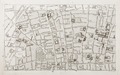 Karta över Paris indelat i 20 distrikt, tryckt 1763 - Skoklosters slott - 86166.tif 3,836 × 2,390; 19.55 MB
-
 Karta över Paris indelat i 20 distrikt, tryckt 1763 - Skoklosters slott - 86167.tif 3,804 × 2,498; 17.81 MB
-
 Louis-Charles Desnos, Nouveau Plan de Paris, ses faubourgs et ses environs, 1767 - Gallica.jpg 9,245 × 6,878; 16.35 MB
-
 Nouveau plan de Paris ses faubourgs et ses environs, 1769 - Paris Musées.jpg 13,672 × 7,623; 75.64 MB

.jpg)


