Category:1720s maps of the wards of London by John Stow
Jump to navigation
Jump to search
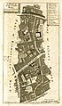
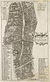
These maps are from the sixth edition of John Stow's "Survay of London".
Media in category "1720s maps of the wards of London by John Stow"
The following 39 files are in this category, out of 39 total.
-

-

-

-

-

-

-
 A map of the Parish of St Mary White Chappel (BM Heal,Topography.231).jpg 2,500 × 1,942; 1.5 MB
-
-

-

-

-

-

-

-

-
 A Mapp of the Parishes of St Saviours Southwark and St Georges (BM Heal,Topography.232).jpg 2,500 × 2,008; 1.79 MB
-
 A New Plan of the City of London, Westminster, and Southwark (BM G,5.1).jpg 2,500 × 1,855; 1.17 MB
-

-
 Billingsgate Cartographer; Blome, RichardSurveyor; Stow, John 1720.jpg 573 × 976; 261 KB
-
 Billingsgate Ward and Bridge Ward Within... (BM Heal,Topography.217).jpg 1,500 × 2,500; 1.07 MB
-

-
 Bishopsgate-Street ward 1720.jpg 578 × 950; 295 KB
-

-

-

-

-

-
 Creplegate Ward... (BM Heal,Topography.208).jpg 2,500 × 2,082; 935 KB
-

-
 Langborne Ward...Candlewick Ward (BM Heal,Topography.221).jpg 2,500 × 2,007; 1.54 MB
-

-
 Shoreditch, Norton Folgate, and Crepplegate Without... (BM Heal,Topography.209).jpg 2,500 × 2,021; 1.11 MB
-

-

-

-
 The Tower and St Catherins (BM Heal,Topography.230).jpg 2,500 × 2,004; 1.45 MB
-

-

-

.jpg)
.jpg)
.jpg)
.jpg)
.jpg)
.jpg)
.jpg)
.jpg)
.jpg)
.jpg)
.jpg)
.jpg)
.jpg)
.jpg)
.jpg)
.jpg)
.jpg)
.jpg)

.jpg)
.jpg)

.jpg)
.jpg)
.jpg)
.jpg)
.jpg)
.jpg)
.jpg)
.jpg)
.jpg)
.jpg)
.jpg)
.jpg)
.jpg)
.jpg)
.jpg)
.jpg)
.jpg)