Beamish Museum: Tramway
The tramway at Beamish Museum runs in a broadly oval shape, connecting the various areas of the site. It's a single track, with three passing loops at stations in the southern half, serving the Entrance, Home Farm and Pockerley areas. A long double track section in the north serves the Town. The whole tramway has an accompanying roadway along its inside edge. The depot is on the west side of the loop, accessed from a spur from the Home Farm loop. With the exception of a block token section between Entrance and Pokerley, access to the single track sections is governed by line of sight and driver knowledge of the service pattern - which in normal service ranges from just 1 tram in the winter, up to 4 in the summer.
Historical images
[edit]-
 1973
1973

Cross site views
[edit]-
 The view west from Pockerley Old Hall, across both the east and west sections of the oval, to the depot
 -
 The view west from Pockerley Old Hall, across both the east and west sections of the oval, to the depot
.jpg)

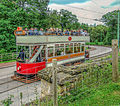
Town double-track section & stops
[edit]Out of Town stops
[edit]Entrance
[edit](shelter)
| Object location | | View all coordinates using: OpenStreetMap |
|---|
The stop serving the Entrance area is at the bottom of the oval, where the track runs in a straight E-W section. The entrance buildings are outside the oval, to the south east, so the shelter is on the south side of the tracks. The shelter is opposite the eastern half of the loop, set back from it. Unlike Home Farm & Pockerley, the track at the entrance loop intrude into the roadway.
-
 Wills's Gold Flake cigarettes advert in the shelter
 -
 Borax Dry Soap advert in the shelter
 -
 The view SE from the stop back to the entrance buildings
 -
 The view SE from the stop back to the entrance buildings
 -
 The view SE from the stop back to the entrance buildings
 -
 A tram approaching the loop, viewed from the west
 -
 A tram beyond the end of the loop being turned, viewed from the west
 -
 A tram beyond the end of the loop being turned, viewed from the west
 -
 A tram beyond the end of the loop being turned, viewed from the west
 -
 A tram in the loop, viewed from the west
 -
 A tram in the loop, viewed from the west
 -
 Trams in the loop, viewed from the west
 -
 A tram in the loop, viewed from the south
 -
 A tram in the loop, viewed from the south
 -
 Trams in the loop, viewed from the south
 -
 A tram in the loop, viewed from the east
 -
 A tram in the loop, viewed from the east
 -
 A tram in the loop, viewed from the east
 -
 A tram in the loop, viewed from the east
 -
 A tram in the loop, viewed from the east
 -
 A tram in the loop, viewed from the east
 -
 A tram in the loop, viewed from the east
 -
 A tram in the loop, viewed from the east
 -
 Trams in the loop, viewed from the east
 -
 Trams in the loop, viewed from the east
 -
 Tram leaving the loop, viewed from the east (from the path up to the entrance building)
 -
 Tram leaving the loop, viewed from the east (from the path up to the entrance building)
 -
 A tram approaching the loop, viewed from the east
 -
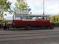
 Eastbound bus on the loop track
 -
 Eastbound bus, east of the loop
 -
 East facing bus, loading at the east end of the loop
 -
 East facing bus, loading at the east end of the loop


.jpg)
.jpg)

_uncropped.jpg)
.jpg)
.jpg)
.jpg)

.jpg)


.jpg)
.jpg)
.jpg)
_uncropped.jpg)

.jpg)


,_Beamish_Museum,_13_November_2013.jpg)
_at_Beamish_Museum,_11_April_2012.jpg)
,_28_September_2011.jpg)
,_28_September_2011.jpg)
,_6_October_2012.jpg)
,_Beamish_Museum,_13_November_2013.jpg)
Home Farm
[edit](shelter)
| Object location | | View all coordinates using: OpenStreetMap |
|---|
The Home Farm stop serves Home Farm, which is outside of the tram oval to the west. It also serves the Pit Village and Colliery, inside the oval, to the east. Road access to both is via junctions south of the loop. There is a single shelter on the east side of the N-S aligned passing loop - meaning the roadway passes between it and the tram lines. The single line NW to the depot joins the oval on the western track of the passing loop.
-
 Trams in the loop, from the south
 -
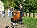 organ grinder, south of the shelter
 -
 Tram in the loop and a southbound bus in the road
 -
 Shelter & tram in the loop, from the SW
 -
 Southbound tram in the top of the loop (viewed from the south)
 -
 Tram in the loop viewed from the south
 -
 Tram in the loop viewed from the south from a bus in the road
 -
 Shelter south gable
 -
 Shelter north end
 -
 Looking east across the end of two trams in the loop, to a southbound bus in the road
 -
 Tram in the loop viewed from the east
 -
 Tram in the loop, southbound bus passing the shelter
 -
 Northbound bus passing the shelter & empty loop
 -
 South end of the loop
 -
 North end of a tram at the southern end of the loop
 -
 North end of a tram at the southern end of the loop, bus arriving from Pit Village on the left


_uncropped.jpg)


.jpg)
_(cropped).jpg)

.jpg)
.jpg)

.jpg)
_uncropped.jpg)

Pockerley
[edit](shelter)
| Object location | | View all coordinates using: OpenStreetMap |
|---|
The Pockerley stop is for people visiting the Georgian Landscape, featuring the Pockerley Waggonway, St Helen’s Church & Pockerley Old Hall. These are all to the east (outside the oval), so the shelter for the stop is on the east side of (and halfway along) the passing loop, which curves from S to NE. The eastern track of the loop continues north into a small siding.
-
 Viewed from the NE, showing the siding
 -
 Viewed from the NE, showing the siding
 -
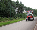 Northbound bus approaches the loop
 -
 Northbound bus approaches the loop
 -
 Southbound tram leaving the loop (approaching the camera)
 -
 Southbound bicyclist, south of the stop
 -
 Southbound bicyclist, south of the stop
 -
 Tram in the loop (w) (viewed from the south)
 -
 Tram in the loop (viewed from the south)
 -
 Tram in the loop (viewed from the south)
 -
 Trams in the loop (viewed from the south)
 -
 Trams in the loop (viewed from the south)
 -
 Trams in the loop (viewed from the south)
 -
 Trams in the loop (viewed from the south)
 -
 Trams in the loop (viewed from the south)
 -
 Shelter from the SW
 -
 Shelter from the SW
 -
 Shelter from the SW
 -
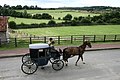 A northbound carriage on the road, seen from a tram in the loop


,_3_August_2011_(1).jpg)
,_3_August_2011_(2).jpg)
.jpg)
.jpg)
.jpg)


.jpg)


.jpg)


.jpg)

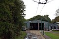
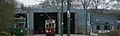
Depot spur & building
[edit]The depot is accessed from a single track spur which runs NW from the passing loop at Home Farm stop. The depot building is a long NW-SE aligned building, in line with the spur.
| Object location | | View all coordinates using: OpenStreetMap |
|---|
-
 The view E across the spur junction
 -
 The view NW from the oval (Home Farm stop) up the depot spur, to the depot
 -
 SE facade
 -
 SE facade
 -
 SE facade
 -
 SE facade
 -
 SE facade
 -
 Parked up outside the tram depot front doors
 -
 Parked up outside the tram depot front doors (to the left)


,_Beamish_Museum,_15_April_2012.jpg)

Single track sections
[edit]SE curve
[edit]-
 Eastbound tram, viewed from the SW (from the path up to the entrance building)
 -
 Looking NE to the curve where the tramway enters the Entrance straight
 -
 Looking NE to the curve where the tramway enters the Entrance straight
 -
 Just south of Pockerley


.jpg)
SW curve
[edit]-
 looking NW
 -
 looking west
 -
 looking east
 -
 looking east
.jpg)
.jpg)
.jpg)
.jpg)
Foulbridge road crossing & depot straight
[edit]| Object location | | View all coordinates using: OpenStreetMap |
|---|
East of the depot is a road crossing on the single track section of the oval north of Home Farm loop, for access onto the interior road.
-
 Looking north from the crossing
 -
 Looking north from the crossing
 -
 Looking south from the crossing

.jpg)
.jpg)
NE section
[edit]-
 Looking north across the section north of Pockerley stop
 -
 Looking north, at the top end of the straight

.jpg)
Unknown
[edit]


Signs
[edit]-
 N.E.A.A. "Caution Carriage Drive On Right" (east of town)
 -
 N.E.A.A. "Dangerous Hill Ahead" (tramway, southern E-W straight)
 -
 Rule 27 (depot spur)
 -
 Crossing sign & delivery driver directions (Foulbridge road crossing)
 -
 Start of Token Section (entrance)
 -
 Start of Token Section (Pockerley)


