Zaanse Schans
Jump to navigation
Jump to search


neighbourhood of Zaandam, Netherlands  | |||||
| Upload media | |||||
| Instance of |
| ||||
|---|---|---|---|---|---|
| Location | Zaanstad, North Holland, Netherlands | ||||
| Inception |
| ||||
| Date of official opening |
| ||||
| Population |
| ||||
| official website | |||||
 | |||||
Construction[edit]

Houses[edit]
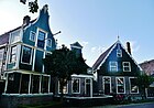
Kalverringdijk[edit]
-
 Kalverringdijk 5 (first shop Albert Heijn)
 -
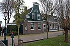
 Kalverringdijk 7 (house on the left)
 -
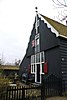
 Kalverringdijk 9 (house on the left)
 -

-

-
-

-

-

-


.jpg)


.jpg)
.jpg)


De Kwakels[edit]
.jpg)
.jpg)
Zeilenmakerspad[edit]
-

-
-

-
-
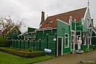
 Zeilenmakerspad 5 (cheese farm)
 -

.jpg)
.jpg)

.jpg)


Zonnewijzerspad[edit]
.jpg)
.jpg)

.jpg)
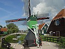
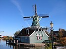
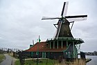
Windmills[edit]
-

-

-

-
-
-
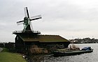
 Het Jonge Schaap (sawmill/zaagmolen)
 -
-
-
 De Os (former mill)
 -

-

.JPG)


_(28534881365).jpg)
.jpg)


Workshops[edit]
-
 Klompenmakerij (Wooden shoe workshop)
 -
 Kraaiennest 4 (same wooden shoe workshop, outside)
 -
 De Catharina Hoeve - Cheese-Making
 -
 Wevershuis (Weaver house)

.jpg)


Other buildings[edit]
-
 Theekoepel (Garden pavilion for having tea)
 -
 Zaans Museum entrance
 -
 Kraaienpad 1 (Restaurant De Kraai)


