User talk:Peacemaker67
|
Our first steps tour and our frequently asked questions will help you a lot after registration. They explain how to customize the interface (for example the language), how to upload files and our basic licensing policy (Wikimedia Commons only accepts free content). You don't need technical skills in order to contribute here. Be bold when contributing and assume good faith when interacting with others. This is a wiki. More information is available at the community portal. You may ask questions at the help desk, village pump or on IRC channel #wikimedia-commons (webchat). You can also contact an administrator on their talk page. If you have a specific copyright question, ask at the copyright village pump. |
|
-- 23:30, 14 January 2012 (UTC)
_location_map.svg)
This message was added automatically by Nikbot, if you need some help about it please read the text above again and follow the links in it, if you still need help ask at the ![]() → Commons:Help desk in any language you like to use. --Nikbot 04:59, 9 September 2012 (UTC)
→ Commons:Help desk in any language you like to use. --Nikbot 04:59, 9 September 2012 (UTC)
This message was added automatically by Nikbot, if you need some help about it please read the text above again and follow the links in it, if you still need help ask at the ![]() → Commons:Help desk in any language you like to use. --Nikbot 02:38, 5 November 2012 (UTC)
→ Commons:Help desk in any language you like to use. --Nikbot 02:38, 5 November 2012 (UTC)

|
File:POW Camp Maribor.jpg has been listed at Commons:Deletion requests so that the community can discuss whether it should be kept or not. We would appreciate it if you could go to voice your opinion about this at its entry.
If you created this file, please note that the fact that it has been proposed for deletion does not necessarily mean that we do not value your kind contribution. It simply means that one person believes that there is some specific problem with it, such as a copyright issue. Please see Commons:But it's my own work! for a guide on how to address these issues. |
Eleassar (t/p) 14:26, 8 November 2012 (UTC)
|
|
File:Leslie Laws.jpg has been listed at Commons:Deletion requests so that the community can discuss whether it should be kept or not. We would appreciate it if you could go to voice your opinion about this at its entry.
If you created this file, please note that the fact that it has been proposed for deletion does not necessarily mean that we do not value your kind contribution. It simply means that one person believes that there is some specific problem with it, such as a copyright issue. Please see Commons:But it's my own work! for a guide on how to address these issues. |
Eleassar (t/p) 14:41, 8 November 2012 (UTC)
|
|
File:Churches and fellow POWs.jpg has been listed at Commons:Deletion requests so that the community can discuss whether it should be kept or not. We would appreciate it if you could go to voice your opinion about this at its entry.
If you created this file, please note that the fact that it has been proposed for deletion does not necessarily mean that we do not value your kind contribution. It simply means that one person believes that there is some specific problem with it, such as a copyright issue. Please see Commons:But it's my own work! for a guide on how to address these issues. |
Eleassar (t/p) 14:42, 8 November 2012 (UTC)
This message was added automatically by Nikbot, if you need some help about it please read the text above again and follow the links in it, if you still need help ask at the ![]() → Commons:Help desk in any language you like to use. --Nikbot 12:56, 16 December 2012 (UTC)
→ Commons:Help desk in any language you like to use. --Nikbot 12:56, 16 December 2012 (UTC)
Hungarian Occupied Yugoslavia Map Request[edit]
Hi Peacemaker, I just saw your request. Sure that would be no problem! I already have a map of WWII Hungary I can use as the source. I'll come up with something, upload it then you can let me know if you need anything changing. The only contentious area I can see is the part also claimed by NDH (Medimurje and Southern Baranya). I believe the Hungarians occupied this area so the de-facto border was probably the Drava river. XrysD (talk) 17:05, 31 December 2012 (UTC)
- that would be brilliant! Peacemaker67 (talk) 22:49, 31 December 2012 (UTC)
- G'day Peacemaker! I've had a go at this one too, but I'm not totally happy with the results yet. I'll tweak it a bit more and let you know when there's something to take a look at. XrysD (talk) 23:14, 2 January 2013 (UTC)
NDH Locator Maps[edit]
Hi, no problem doing these either :) They're quicker than the first request so I've done them and uploaded them to commons [[1]]. The demarcation line is from Tomasevich p.62. Will take a look at the other request today. XrysD (talk) 10:29, 1 January 2013 (UTC)
- Great. Now, I'm no expert at this, but can I use this as a Location map (per "Category:Location maps of Europe") as well? Peacemaker67 (talk) 12:10, 1 January 2013 (UTC)
- Hi, apparently I need to create a Location map NDH template for use with these maps. Can you give me the:
- latitude of the top edge of the image using decimal degrees
- latitude of the bottom edge of the image
- longitude of the left edges of the image
- longitude of the right edges of the image
That would be brilliant. Thanks a lot for your work! Regards, Peacemaker67 (talk) 11:09, 2 January 2013 (UTC)
- No probs! :) OK, well the maps aren't in a Mercator projection so the edges aren't constant lat/long, but the mean values are:
- LAT TOP = 47.00N
- LAT BOTTOM = 42.25N
- LONG LEFT = 14.25E
- LONG RIGHT = 21.00E
- The locator map for 1943-45 has also been updated to include the Kommissariat that Bojovnik requested. XrysD (talk) 23:12, 2 January 2013 (UTC)
- Excellent, I've done a template for it now and added it to my ACR article. Given the Vienna line was no longer relevant after the Italians capitulated, could you take it off the 43 one? That would be great. Many thanks once again! You are a legend! Peacemaker67 (talk) 01:34, 3 January 2013 (UTC)
- No probs! :) OK, well the maps aren't in a Mercator projection so the edges aren't constant lat/long, but the mean values are:
NDH[edit]
Sorry, I was reading your correspondence wih XrysD and accidentaly put this request on the wrong place. All the best,--Bojovnik (talk) 14:31, 2 January 2013 (UTC)
Copyright status: File:HMAS Wallaroo.jpg[edit]
| This media may be deleted. |
Thanks for uploading File:HMAS Wallaroo.jpg. I notice that the file page either doesn't contain enough information about the license or it contains contradictory information about the license, so the copyright status is unclear.
If you created this file yourself, then you must provide a valid copyright tag. For example, you can tag it with {{self|GFDL|cc-by-sa-all}} to release it under the multi-license GFDL plus Creative Commons Attribution-ShareAlike All-version license or you can tag it with {{PD-self}} to release it into the public domain. (See Commons:Copyright tags for the full list of license tags that you can use.) If you did not create the file yourself or if it is a derivative of another work that is possibly subject to copyright protection, then you must specify where you found it (e.g. usually a link to the web page where you got it), you must provide proof that it has a license that is acceptable for Commons (e.g. usually a link to the terms of use for content from that page), and you must add an appropriate license tag. If you did not create the file yourself and the specific source and license information is not available on the web, you must obtain permission through the VRT system and follow the procedure described there. Note that any unsourced or improperly licensed files will be deleted one week after they have been marked as lacking proper information, as described in criteria for deletion. If you have uploaded other files, please confirm that you have provided the proper information for those files, too. If you have any questions about licenses please ask at Commons:Village pump/Copyright or see our help pages. Thank you. |
Yours sincerely, JuTa 22:22, 30 June 2013 (UTC)
Hungary Territorial Gains Map[edit]
Hi Peacemaker! I saw your request to edit File:TeritorialGainsHungary1920-41.svg. I've had a look at it and I'm not sure why such a change is needed to be honest. The legend is legible even when the image is viewed in thumbnail size to me. And making it any bigger would make it over-scale for the image itself. What is the rationable behind the change. Also did you try to contact the author about this? I pm'd him but have not got a response. XrysD (talk) 15:55, 23 July 2013 (UTC)
- Hi XrysD, thanks for replying. I have managed to fix it with a photoshop jpg in the meantime. I am about to start working on the invasion of Yugoslavia article, and I was wondering if you would be able to tweak File:Yugoslavia (1929-1939) location map.svg to show the 1939-1941 boundaries (post the Sporazum, ie including Banovina Croatia)? Regards, Peacemaker67 (talk) 02:21, 24 July 2013 (UTC)
- Hi again. I've not got any maps showing Banovina Croatia so at the moment the answer is no. Also the maps I do have of the Banovinas 1929-39 don't agree with the existing map anyway! If you have some good quality source maps I can have a go though XrysD (talk) 11:38, 27 July 2013 (UTC)
Hungarian Occupied Yugoslavia[edit]
G'day Peacemaker! I have a good source map of Hungary 1941-44 so it should be possible to do something. What exactly do you want the map to show? Hungarian admin or former Yugoslav admin? XrysD (talk) 18:57, 7 August 2013 (UTC)
- I think what we need is a map showing the four regions within the Hungarian occupation, with lines or fuzzy lines showing the regions, but also showing how the occupied areas were integrated into the Hungarian subdivisions. What do you think? Peacemaker67 (talk) 23:29, 7 August 2013 (UTC)
- I just remembered you already asked about this earlier this year! I dug out what I'd done before, finished it off and now I'm happy with it. I've uploaded it now so have a look and tell me if it's what you want File:Hungarian_Occupied_Yugoslavia_1941_44.png. Cheers, XrysD (talk) 21:36, 9 August 2013 (UTC)
- That looks really good. Do your source maps show the small slice of the western territories that were annexed to Reichsgau Steiermark? Peacemaker67 (talk) 23:25, 9 August 2013 (UTC)
- Yes I have source maps that cover the parts annexed to the Third Reich. Would you like another map that shows that? XrysD (talk) 08:28, 10 August 2013 (UTC)
- Could you add the little German annexed slice of northeastern Prekmurje to the map you've done? Peacemaker67 (talk) 09:48, 10 August 2013 (UTC)
- Yes I have source maps that cover the parts annexed to the Third Reich. Would you like another map that shows that? XrysD (talk) 08:28, 10 August 2013 (UTC)
- That looks really good. Do your source maps show the small slice of the western territories that were annexed to Reichsgau Steiermark? Peacemaker67 (talk) 23:25, 9 August 2013 (UTC)
- I just remembered you already asked about this earlier this year! I dug out what I'd done before, finished it off and now I'm happy with it. I've uploaded it now so have a look and tell me if it's what you want File:Hungarian_Occupied_Yugoslavia_1941_44.png. Cheers, XrysD (talk) 21:36, 9 August 2013 (UTC)
- Ahh... apologies, I thought you were referring to the more significant area to the south that is now part of Slovenia. As far as I was aware, Prekmurje was occupied by Hungary alone (while the regime lasted). My source maps in that area don't show any part of Prekmure annexed to Germany. Do you have a source map that shows it? XrysD (talk) 10:37, 10 August 2013 (UTC)
- It was only four villages, apparently. So no. I am very happy with the map you've done, the German bit isn't strictly relevant to the article. There was a particular reviewer that requested it, I'll ping them and see what they think. Thanks again, Peacemaker67 (talk) 13:14, 10 August 2013 (UTC)
WWII images[edit]
All the files that I have uploaded from Znaci are in Public Domain, see the licence at the bottom of the page. I gave them template PD-Yugoslavia, because the photos are from Yugoslavia. But maybe it is better to put the same teplate as User:Ipos here ? --Mladifilozof (talk) 10:16, 2 July 2014 (UTC)
- With respect, the online publisher isn't even clear. I mean who is "znaci", and what authority do they have to state that the images are PD? Do they own them? Did they publish them before 1966? There is no evidence that these images were published prior to 1966. The website wasn't published prior to 1966, so these images would have to have been published in a book or similar prior to 1966 in order to be PD. Regards, Peacemaker67 (talk) 08:06, 4 July 2014 (UTC)
_location_map.svg)
Hello! Where is a problem with a hyphen? There are many location maps with a hyphen and I do not know of any problem. Regards, NNW 14:53, 4 July 2014 (UTC)
_location_map.svg)
- The WP MOS states dates should be endashed, and year ranges should be truncated. Everytime anyone ran a dash script over articles using the location maps they broke the syntax. Cheers, Peacemaker67 (talk) 03:59, 9 July 2014 (UTC)
- First of all this is Commons, not en:WP, so WP:MOS isn't interesting at all. And if there is a problem with a hyphen in a file name please tell me why there is no problem with file:Sudan (2005-2011) location map.svg which is in use since 2012? NNW 06:48, 9 July 2014 (UTC)
- Look, quite obviously I know this isn't WP, the logo in the corner is a bit of a giveaway. I'm telling you what was happening to this location map when it was used in articles on WP, which is where this file gets used. I asked for the name change so it wouldn't happen on WP anymore when people run dash scripts on articles. It's not that big a deal, surely? Peacemaker67 (talk) 11:41, 9 July 2014 (UTC)
- First of all this is Commons, not en:WP, so WP:MOS isn't interesting at all. And if there is a problem with a hyphen in a file name please tell me why there is no problem with file:Sudan (2005-2011) location map.svg which is in use since 2012? NNW 06:48, 9 July 2014 (UTC)
_location_map.svg)
- I just asked for the reason why this file was moved. Reason: hyphen syntax is causing issues with articles on WP using this location map is irritating because I have never heard of such a problem before and there is no other location map with that problem. Could you give me link to an article where this happened? It might happen at other projects, too, and I would like to avoid problems. Btw: Moving this file destroyed the Yugoslavia location map name scheme with file:Yugoslavia (1929-1939) location map.svg and file:Yugoslavia (1946-1990) location map.svg. I try to keep names consistent and that's why I asked. NNW 16:25, 9 July 2014 (UTC)
_location_map.svg)
_location_map.svg)
- OK, the first time I noticed it was here when someone ran AWB. You can see there was a script error after the dashes were fixed by AWB. See what I mean? Cheers, Peacemaker67 (talk) 04:15, 10 July 2014 (UTC)
NDH series of maps[edit]
Hi Peacemaker,
Well as I mentioned I am updating this series at the moment as I have better source data for the districts. But basically the main sources I used for the whole series are as follows:
NDH national borders. These come from the contemporary 1:300k Ubersichtskarte von Mitteleuropa or 1:100k Karte des Deutschen Reiches. Mostly sourced from Map Archive of Wojskowy Instytut Geograficzny
NDH county borders. The prime source is "Croatia, OR 5360. London : War Office, 1941" (in the BL Maps MOD OR 5360)
NDH district borders. These are simply the districts of the pre-existing Yugoslavia. Main source here "Kraljevina Jugoslavija = Royaume de Yougoslavie, MDR Misc 7596. Cairo: Survey Directorate, Middle East, 1944" (BL Maps MOD MDR Misc 7596)
In addition to these sources I used the following internet one:
Note: this is not the original location of this image, that website seems to be offline now. This map was used for the boundaries after the capitultion of Italy (OR 5360 shows the pre-1943 borders) NDH Internet Map
The only other change was to include the district of Susak-Krk, the explanation for which and sources are on my talk page.
Hope that helps! XrysD (talk) 09:27, 19 October 2014 (UTC) Thanks very much! Regards, Peacemaker67 (talk) 12:16, 19 October 2014 (UTC)
Balkans Maps[edit]
Hi Peacemaker, thanks for your continuing appreciation :) I accept your point entirely about the extremely limited duration of the independence of Montenegro. That's why the map on en:wp refers to the governorate only and uses the Italian names. This is clearly the WP:CON here. However as I'm sure you've noticed, the views over at sr:wp are somewhat different! In general, whatever my personal views are on the subject, I try to take a pragmatic view where my maps are concerned. As I see it the choice is to either produce a map version that is acceptable to the particular WP:CON or not. If I do the latter then it will just be edited, or a copy made, then that edited by someone without the original source material, resulting in a substandard map either way. A good reverse example is the map of the Territory of the Mil Cdr in Serbia. It's clear to me from my many source maps that although the official full name was that, it was also colloquially known as simply Serbia by both sides and not just the Serbs themselves. But it would be unacceptable to use this as the map title on en:wp for all the reasons I won't repeat here. I guess what I am saying is my aim is to maximise the quality, integrity and maintainability of my maps and avoid diverging substandard versions as much as possible. I would however never label anything with a name that is totally unsupportable. XrysD (talk) 00:32, 6 April 2015 (UTC)
- No worries. I completely understand your position. Keep up the good work! Regards, Peacemaker67 (talk) 14:15, 6 April 2015 (UTC)
Re:Query[edit]
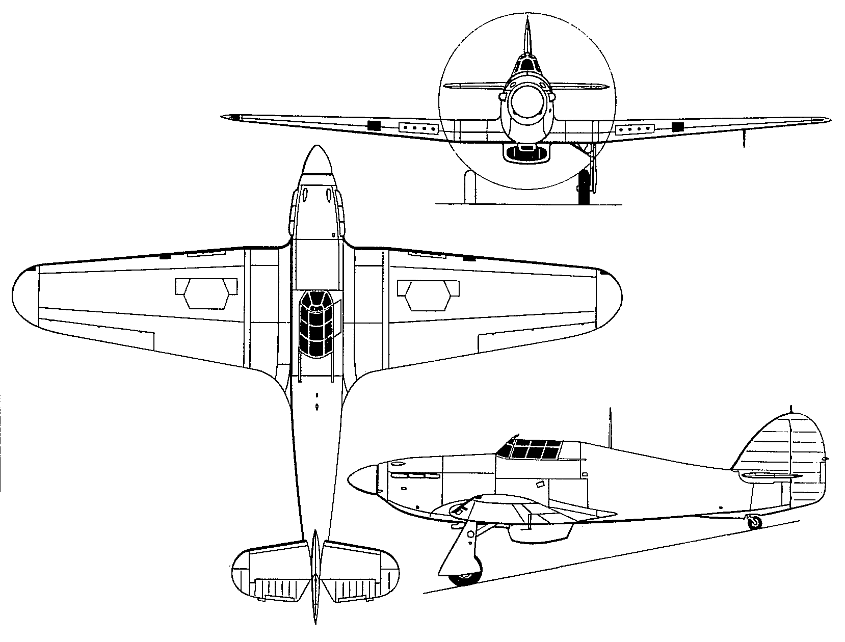
Hello! The drawing is the result of a comparison between a few 3-views I was able to find on the internet (including this one). I hope this was helpful! --M.L.WattsAir Mail ✈ 09:42, 2 October 2016 (UTC)
- Thanks very much! Did the trick. Regards, Peacemaker67 (talk) 09:16, 4 October 2016 (UTC)
HMAS Warreen / Stella[edit]
Well done for finding a pic at the AWM. I did not think of looking under its other name.Peter Ellis (talk) 11:38, 20 October 2017 (UTC)
Chetnik Future Serbia[edit]
G'Day Peacemaker! Yes I would be interested in doing the map you requested. I don't have a copy of Tomasevich's book so please e-mail me the scan and I'll take a look. XrysD TALK 10:45, 6 August 2020 (UTC)
- Hi, just to say I haven't forgotten about the map. I had a good look through the text with the sketch map but it wasn't amazingly useful in defining the areas more accurately. For example he talks about annexing "Kjustendil and Vidin Districts" in Bulgaria. I've not been able to find anything named that covering the sort of area shown. There are Vidin and Kjustendil districts but they are much smaller. So at the moment any more accurate map I can come up with would be quite speculative based on Greater Serbia only containing the nearest whole admin units in those countries corresponding to the sketch map. But of course it might actually go by a river or a mountain range just as well. So I guess what I am saying is more info is needed, be that more maps or better descriptions. XrysD TALK 17:20, 26 November 2020 (UTC)
- OK, thanks for your research so far, XrysD! I will see what else I can find. Regards, Peacemaker67 (talk) 00:36, 27 November 2020 (UTC)
Copyright status: File:Chetnik leader Predrag Raković.jpg[edit]
Copyright status: File:Chetnik leader Predrag Raković.jpg
| This media may be deleted. |
Thanks for uploading File:Chetnik leader Predrag Raković.jpg. I notice that the file page either doesn't contain enough information about the license or it contains contradictory information about the license, so the copyright status is unclear.
If you created this file yourself, then you must provide a valid copyright tag. For example, you can tag it with {{self|GFDL|cc-by-sa-all}} to release it under the multi-license GFDL plus Creative Commons Attribution-ShareAlike All-version license or you can tag it with {{PD-self}} to release it into the public domain. (See Commons:Copyright tags for the full list of license tags that you can use.) If you did not create the file yourself or if it is a derivative of another work that is possibly subject to copyright protection, then you must specify where you found it (e.g. usually a link to the web page where you got it), you must provide proof that it has a license that is acceptable for Commons (e.g. usually a link to the terms of use for content from that page), and you must add an appropriate license tag. If you did not create the file yourself and the specific source and license information is not available on the web, you must obtain permission through the VRT system and follow the procedure described there. Note that any unsourced or improperly licensed files will be deleted one week after they have been marked as lacking proper information, as described in criteria for deletion. If you have uploaded other files, please confirm that you have provided the proper information for those files, too. If you have any questions about licenses please ask at Commons:Village pump/Copyright or see our help pages. Thank you. |
This action was performed automatically by AntiCompositeBot (talk) (FAQ) 04:05, 2 October 2021 (UTC)
- I think I've fixed this. Peacemaker67 (talk) 04:21, 2 October 2021 (UTC)
Copyright status: File:Portrait of Bill Madden.jpg[edit]
Copyright status: File:Portrait of Bill Madden.jpg
| This media may be deleted. |
Thanks for uploading File:Portrait of Bill Madden.jpg. I notice that the file page either doesn't contain enough information about the license or it contains contradictory information about the license, so the copyright status is unclear.
If you created this file yourself, then you must provide a valid copyright tag. For example, you can tag it with {{self|GFDL|cc-by-sa-all}} to release it under the multi-license GFDL plus Creative Commons Attribution-ShareAlike All-version license or you can tag it with {{PD-self}} to release it into the public domain. (See Commons:Copyright tags for the full list of license tags that you can use.) If you did not create the file yourself or if it is a derivative of another work that is possibly subject to copyright protection, then you must specify where you found it (e.g. usually a link to the web page where you got it), you must provide proof that it has a license that is acceptable for Commons (e.g. usually a link to the terms of use for content from that page), and you must add an appropriate license tag. If you did not create the file yourself and the specific source and license information is not available on the web, you must obtain permission through the VRT system and follow the procedure described there. Note that any unsourced or improperly licensed files will be deleted one week after they have been marked as lacking proper information, as described in criteria for deletion. If you have uploaded other files, please confirm that you have provided the proper information for those files, too. If you have any questions about licenses please ask at Commons:Village pump/Copyright or see our help pages. Thank you. |
This action was performed automatically by AntiCompositeBot (talk) (FAQ) 03:05, 16 November 2023 (UTC)
- Sorted. Peacemaker67 (talk) 03:33, 16 November 2023 (UTC)