User talk:Oie blanche
|
Our first steps tour and our frequently asked questions will help you a lot after registration. They explain how to customize the interface (for example the language), how to upload files and our basic licensing policy (Wikimedia Commons only accepts free content). You don't need technical skills in order to contribute here. Be bold when contributing and assume good faith when interacting with others. This is a wiki. More information is available at the community portal. You may ask questions at the help desk, village pump or on IRC channel #wikimedia-commons (webchat). You can also contact an administrator on their talk page. If you have a specific copyright question, ask at the copyright village pump. |
|
.jpg)
Full France Map[edit]
Bonjour, I'm currently looking at the old french regions for a project I'm working on. Your maps are really useful for it, but I need a map of the whole of france rather than just maps for the individual provinces. I don't suppose you have made on at some point have you? Merci, Mattymooz (talk) 21:49, 26 October 2018 (UTC)
-- Wikimedia Commons Welcome (talk) 10:09, 15 January 2013 (UTC)
.jpg)
This message was added automatically by Nikbot, if you need some help about it please read the text above again and follow the links in it, if you still need help ask at the ![]() → Commons:Help desk in any language you like to use. --Nikbot 04:43, 20 January 2013 (UTC)
→ Commons:Help desk in any language you like to use. --Nikbot 04:43, 20 January 2013 (UTC)
This message was added automatically by Nikbot, if you need some help about it please read the text above again and follow the links in it, if you still need help ask at the ![]() → Commons:Help desk in any language you like to use. --Nikbot 04:57, 20 January 2013 (UTC)
→ Commons:Help desk in any language you like to use. --Nikbot 04:57, 20 January 2013 (UTC)
File tagging File:Jardin de la Perrine 3.JPG[edit]
|
| |
File:Jardin de la Perrine 3.JPG which you uploaded has been tagged with {{OTRS pending}} for more than 30 days. This tag indicates that an email setting out permission to use the file was sent to the Volunteer Response Team. Unfortunately, we cannot find any record that such an email has been received, and accordingly the file remains without permission. Unless the Volunteer Response Team receives evidence that permission has been granted within 15 days of today's date, the file will be deleted. If you have already sent the permission, please re-send it to permissions-commons@wikimedia.org now. Please quote the file name ("File:Jardin de la Perrine 3.JPG") in your email. At the same time, please leave a message at the VRT noticeboard so that a volunteer can follow this up or contact a VRT member directly.
| |
Denniss (talk) 10:37, 3 July 2013 (UTC)
File tagging File:St-Vénérand Laval 2.JPG[edit]
|
| |
File:St-Vénérand Laval 2.JPG which you uploaded has been tagged with {{OTRS pending}} for more than 30 days. This tag indicates that an email setting out permission to use the file was sent to the Volunteer Response Team. Unfortunately, we cannot find any record that such an email has been received, and accordingly the file remains without permission. Unless the Volunteer Response Team receives evidence that permission has been granted within 15 days of today's date, the file will be deleted. If you have already sent the permission, please re-send it to permissions-commons@wikimedia.org now. Please quote the file name ("File:St-Vénérand Laval 2.JPG") in your email. At the same time, please leave a message at the VRT noticeboard so that a volunteer can follow this up or contact a VRT member directly.
| |
Denniss (talk) 10:37, 3 July 2013 (UTC)
File tagging File:Jardin de la Perrine Laval 5.JPG[edit]
|
| |
File:Jardin de la Perrine Laval 5.JPG which you uploaded has been tagged with {{OTRS pending}} for more than 30 days. This tag indicates that an email setting out permission to use the file was sent to the Volunteer Response Team. Unfortunately, we cannot find any record that such an email has been received, and accordingly the file remains without permission. Unless the Volunteer Response Team receives evidence that permission has been granted within 15 days of today's date, the file will be deleted. If you have already sent the permission, please re-send it to permissions-commons@wikimedia.org now. Please quote the file name ("File:Jardin de la Perrine Laval 5.JPG") in your email. At the same time, please leave a message at the VRT noticeboard so that a volunteer can follow this up or contact a VRT member directly.
| |
Denniss (talk) 10:37, 3 July 2013 (UTC)
Cartes comparant les provinces françaises et les divisions actuelles[edit]
Bonjour Oie blanche,
Tout d'abord, bravo pour ces cartes très utiles et instructives sur la composition des départements et régions françaises actuels vis-à-vis des anciennes provinces. Est-ce que tu pourrais simplement ajouter à la description des fichiers les sources qui t'ont permis de faire ces cartes (cartes de Guillaume Delisle et de ses contemporains j'imagine). ça permettrait d'assurer dans le temps la fiabilité et l'usage de ces cartes. Bien cordialement, Bzh-99 (talk) 19:36, 16 January 2014 (UTC)
- EDIT : Je vois que tu l'as fait sur pas mal de cartes, mais celle-ci a été oubliée. - Bzh-99 (talk) 19:45, 16 January 2014 (UTC)
- C'est fait ! Oie blanche (talk)
Carte dialecte Gallo[edit]
Il me semble que le Pays de Retz fait partie de l'aire du Poitevin-Saintongeais. Je me trompe ? C'est peut-être la rencontre entre les deux dialectes, s'influençant mutuellement.
Bona jornada
Jiròni B
- Bonjour, je suppose que vous parlez d'une des cartes qui illustrent les phénomènes phonétiques en gallo. Ces cartes sont réalisées d'après des documents que j'ai trouvé dans des ouvrages sur le gallo, que j'ai scrupuleusement respectés, donc je n'ai pas personnellement choisi les limites qu'elles donnent à l'aire linguistique du gallo. Par ailleurs, le Pays de Retz est une zone de transition entre gallo et poitevin, donc effectivement il n'existe pas de limite claire entre les deux. J'espère avoir répondu à votre question. Cordialement, Oie blanche (talk) 17:32, 27 March 2014 (UTC)
Bonjour, au sujet de votre carte concernant les langues d'oïl d'après Marie-Rose Simoni-Arenbou et le positionnement du Croissant marchois (qui rappelle la perception qu'en avaient Coquebert de Montbret père et fils au XIXe siècle ou Ernest Negre au XXe), pourriez-vous m'indiquer les éléments qui ont conduit au placement du Croissant en zone d'oïl ? JM Monnet-Quelet

|
File:Carte de la Bourgogne.svg has been listed at Commons:Deletion requests so that the community can discuss whether it should be kept or not. We would appreciate it if you could go to voice your opinion about this at its entry.
If you created this file, please note that the fact that it has been proposed for deletion does not necessarily mean that we do not value your kind contribution. It simply means that one person believes that there is some specific problem with it, such as a copyright issue. Please see Commons:But it's my own work! for a guide on how to address these issues. |
171.16.208.4 12:23, 15 October 2015 (UTC)
Cartes zone d'oil[edit]
Bonjour Oie blanche. Merci pour ta carte File:Langues d'oïl Simoni-Aurembou.svg. Cependant, la zone du saintongeais est inexacte : le sud de la Charente-Maritime doit être inclus, ainsi qu'une petite zone de la Gironde, autour de Blaye (et minuscule à l'ouest de la Dordogne). De plus, dans wikipedia, le Croissant est considéré comme une zone occitane. Il y a aussi une limite entre saintongeais et poitevin (à peu près entre Charentes et Poitou). Cordialement, Jack ma (talk) 06:30, 6 December 2015 (UTC)
|
|
File:Langues d'oïl Walter.svg has been listed at Commons:Deletion requests so that the community can discuss whether it should be kept or not. We would appreciate it if you could go to voice your opinion about this at its entry.
If you created this file, please note that the fact that it has been proposed for deletion does not necessarily mean that we do not value your kind contribution. It simply means that one person believes that there is some specific problem with it, such as a copyright issue. Please see Commons:But it's my own work! for a guide on how to address these issues. |
Reventtalk 12:22, 23 August 2016 (UTC)
Bonjour,
J'ai conservé ce fichier. J'ai aussi corrigé « OCCITAN » en « LANGUE D’OC » est-ce que tout est bon maintenant ?
Cdlt, VIGNERON (talk) 11:54, 30 August 2016 (UTC)
File tagging File:Grandes Armes de Rouen.svg[edit]
This media was probably deleted.
|
Thanks for uploading File:Grandes Armes de Rouen.svg. This media is missing permission information. A source is given, but there is no proof that the author or copyright holder agreed to license the file under the given license. Please provide a link to an appropriate webpage with license information, or ask the author or copyright holder to send an email with copy of a written permission to VRT (permissions-commons@wikimedia.org). You may still be required to go through this procedure even if you are the author yourself; please see Commons:But it's my own work! for more details. After you emailed permission, you may replace the {{No permission since}} tag with {{subst:PP}} on file description page. Alternatively, you may click on "Challenge speedy deletion" below the tag if you wish to provide an argument why evidence of permission is not necessary in this case.
Please see this page for more information on how to confirm permission, or if you would like to understand why we ask for permission when uploading work that is not your own, or work which has been previously published (regardless of whether it is your own). The file probably has been deleted. If you sent a permission, try to send it again after 14 days. Do not re-upload. When the VRT-member processes your mail, the file can be undeleted. Additionally you can request undeletion here, providing a link to the File-page on Commons where it was uploaded ([[:File:Grandes Armes de Rouen.svg]]) and the above demanded information in your request. |
Chiyako92 (talk) 10:15, 9 March 2019 (UTC)
Permission - droits d'auteur[edit]
Bonjour,
À propos du changement suivant https://commons.wikimedia.org/w/index.php?title=File:Panorama_depuis_Butte_Sainte-Anne.jpg&diff=prev&oldid=237228645
|permission=The Maillé-Brézé ship (built in 1955) and the Tour Bretagne (built 1971-1976) are subject to copyright but are not the main subject of the picture.
Pour la Tour Bretagne OK pour la note
Pour le Maillé-Brézé, je ne sais pas.
Dans cette catégorie https://commons.wikimedia.org/wiki/Category:Maillé-Brézé_(D627), dont toutes les photos ont pour sujet principal le Maillé-Brézé, il n' y a aucun avertissement ou notice.
Et sur Wikimedia Commons c'est la même chose pour de nombreux autres navires et de même pour les catégories.
Exemples :
- Navire de 1987 => https://commons.wikimedia.org/wiki/Category:Lyre_M648_(ship,_1987)
- Navire de 2004 => https://commons.wikimedia.org/wiki/Category:A759_Dupuy_de_Lôme_(ship,_2005)
- Navire de 2012 => https://commons.wikimedia.org/wiki/Category:D650_Aquitaine_(ship,_2012)
- Et de même pour les bâtiments non militaires => https://commons.wikimedia.org/wiki/File:2014-08-25_Bordeaux,_Azamara_journey,_arrière_(1).JPG
.JPG)
Apparemment les navires du genre de ceux cités ci-dessus ne semblent pas assujetis aux droits d'auteur.
C'est bizarre.
Je sais que dans le cas des bateaux ne sont protégées au niveau du droit d'auteur que les formes lorsqu'elles sont originales (pas pour les séries), le « reste » soit tout ce qui est technique est protégé par la propriété industrielle.
À creuser
Eric Brosselin (talk) 12:31, 23 February 2020 (UTC)
File:Carte du Dauphiné.svg[edit]
Bonjour Oie Blanche, Super tes cartes! Je voudrais juste préciser que sur la carte du Dauphiné il manque l'Escarton de Chateau Dauphin en Italie (perdu en 1713 comme Bardonnèche). Pourrais tu remedier à cela. Merci --Isoletta38 (talk) 16:34, 23 April 2020 (UTC)
|
|
File:Dragon Protects.jpg has been listed at Commons:Deletion requests so that the community can discuss whether it should be kept or not. We would appreciate it if you could go to voice your opinion about this at its entry.
If you created this file, please note that the fact that it has been proposed for deletion does not necessarily mean that we do not value your kind contribution. It simply means that one person believes that there is some specific problem with it, such as a copyright issue. Please see Commons:But it's my own work! for a guide on how to address these issues. |
2A01:CB00:A05:D100:34BA:C355:EAC:CC3E 14:05, 31 October 2020 (UTC)
Notification about possible deletion[edit]
|
|
Some contents have been listed at Commons:Deletion requests so that the community can discuss whether they should be kept or not. We would appreciate it if you could go to voice your opinion about this at their entry.
If you created these pages, please note that the fact that they have been proposed for deletion does not necessarily mean that we do not value your kind contribution. It simply means that one person believes that there is some specific problem with them, such as a copyright issue. Please see Commons:But it's my own work! for a guide on how to address these issues. |
Affected:
And also:
- File:Auguste Rodin Tatin.jpg
- File:Cheeky Monster Tatin.jpg
- File:Delicious Tatin.jpg
- File:Dragon Protects.jpg
- File:Garden and Pond Tatin.jpg
- File:Goddess Tatin.jpg
- File:Green God Tatin.jpg
- File:Jeanne D'Arc Tatin.jpg
- File:La Frenouse.jpg
- File:La Vierge de L'Epine Tatin.jpg
- File:Picasso Tatin.jpg
- File:See Hear Speak Tatin.jpg
- File:Seurat Tatin.jpg
- File:Suzanne Valadon Tatin.jpg
- File:To Be.jpg
- File:Toulouse Lautrec Tatin.jpg
- File:View inside the grotto 2.jpg
- File:View towards "nôtre dame tout le monde".jpg
- File:Yin Yang Tatin.jpg
Yours sincerely, Chassipress (talk) 16:26, 31 October 2020 (UTC)
Carte de l'Angoumois[edit]
Pouvez-vous ajouter à la carte de l'Angoumois une exclave qu'il y avait au sud-ouest (enclave d'Angoumois en Saintonge, appelée Petit Angoumois), correspondant en gros aux communes du canton de Baignes-Sainte-Radegonde. Merci pour cette carte. Cordialement, Jack ma (talk) 08:01, 29 November 2020 (UTC)
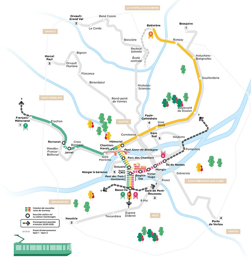
Erreur plan du tramway de Nantes[edit]
Bonjour,
J'ai remarqué que vous aviez ajouté un plan des futures lignes 6, 7 et 8 du Tramway de Nantes, sauf que celui-ci contient une erreur : la ligne 7 passera bien par la station Romanet après la station Jamet comme il est indiqué sur le plan officiel. Pourriez-vous corriger ?
Merci d'avance BN&Cie (talk) 11:40, 11 January 2021 (UTC)
- Merci pour votre attention, l'erreur est corrigée. Oie blanche (talk) 14:55, 23 February 2021 (UTC)
Cartes des provinces de France[edit]
Bonjour,
Je vous écris concernant les cartes des anciennes provinces de France que vous avez faites. Ça a du demandé beaucoup de travail, mais elles sont pleines d'imprécisions, à l'instar des cartes utilisées comme sources. Pourrais-je vous aider à corriger certaines erreurs, notamment concernant les contours de la province d'Alsace ?
Cordialement, Jacky (aka Hàlt 's Mühl) (talk) 13:07, 5 May 2021 (UTC)
Votre carte des langues d'oïl d'après Simoni-Aurembou :[edit]
Bonjour. Pour la carte des langues d'oïl que vous avez faite, à partir des données de Simoni-Aurembou, vous citez une source : Géographie linguistique et biologie du langage : Autour de Jules Gillieron, Peter Luwers, Marie-Rose Simoni-Aurembou,Pierre Swigers, éd. Peeters, 2003, p. 138 J'ai acheté le bouquin, pour voir. L'édition est de 2002 et non de 2003. Même exact titre, mêmes auteurs, même éditeur. Mais pas de carte des langues d'oïl à la page que vous citez p. 138, ni ailleurs dans le livre. Et pas non plus de données textuelles qui vous auraient permis de faire cette carte, ni à cette page ni ailleurs dans le livre... Sauf erreur de ma part, vous avez fait une erreur de sourçage. A corriger donc (et je veux bien savoir quelle est la vraie source, ça m'intéresse !) Bonne continuation. Cagouillat (talk) 22:24, 6 December 2022 (UTC) Cagouillat (talk) 22:26, 6 December 2022 (UTC)