User talk:NordNordWest/Archive6
Special:RecentChangesLinked/Category:Pages using Information template with incorrect parameter[edit]
Hallo NordNordWest. Weisst du, wie die URLs korrigiert werden müssen, damit sie wieder funktionieren und auch keinen Syntaxfehler mehr ergeben? --Leyo 19:30, 5 January 2014 (UTC)
- Moin! Nein, ich habe keine Ahnung. Ich verstehe auch nicht, warum am Ende so viele ] stehen. NNW 09:18, 6 January 2014 (UTC)
- https://commons.wikimedia.org/w/index.php?title=File%3AVerwaltungsgemeinschaft_Mittleres_Nessetal_in_GTH.svg&diff=113353967&oldid=113297847 --TUBS
 11:50, 6 January 2014 (UTC)
- Klasse, danke. NNW 12:41, 6 January 2014 (UTC)
- @TUBS: Gibt es ein allgemeingültiges „Korrekturmuster“ für alle entsprechenden Dateien? Sonst wird es schwierig, das automatisiert zu korrigieren. --Leyo 20:23, 6 January 2014 (UTC)
- Das allgemeingültige Muster lautet: 1. den Dreck löschen 2. den neuen Link rein 3. Könnte man ja mit dem Auto-Wiki Browser machen (Find&Replace), wenn's so wichtig ist.
- @TUBS: Gibt es ein allgemeingültiges „Korrekturmuster“ für alle entsprechenden Dateien? Sonst wird es schwierig, das automatisiert zu korrigieren. --Leyo 20:23, 6 January 2014 (UTC)
- Klasse, danke. NNW 12:41, 6 January 2014 (UTC)
- https://commons.wikimedia.org/w/index.php?title=File%3AVerwaltungsgemeinschaft_Mittleres_Nessetal_in_GTH.svg&diff=113353967&oldid=113297847 --TUBS
- Etwas Intelligenteres kann ich dazu nicht sagen, da ich auch keine Ahnung habe was da schief gelaufen ist. Möglicherweise war das früher mal die korrekte url der Datei (die dann eingefügt wurde obwohl wiki sich dran verschluckt). Ich kann nicht mal sagen ob ich oder Hagar Schuld auf sich geladen haben --TUBS 21:12, 6 January 2014 (UTC)
- @TUBS: Kommt denn immer dieselbe URL (ev. bis auf wenige Parameterwerte) hin? Je nachdem könnten die Korrekturen mittels VFC gemacht werden. --Leyo 23:34, 6 January 2014 (UTC)
- Man muss halt Von *[http://www.landkreis-gotha.de bis |Date ersetzen durch *[http://www.landkreis-gotha.de/index.php?eID=tx_cms_showpic&file=uploads%2Fpics%2Fvg_karte_2014.jpg&width=1024&height=800m&bodyTag=%3Cbody%20style%3D%22margin%3A0%3B%20background%3A%23fff%3B%22%3E&wrap=%3Ca%20href%3D%22javascript%3Aclose%28%29%3B%22%3E%20%7C%20%3C%2Fa%3E&md5=64f67d302ca4bd43de62491ad780ff8c Landratsamt Gotha ''Städte, Gemeinden und Verwaltungsgemeinschaften'']|Date= --TUBS 08:58, 10 January 2014 (UTC)
- @TUBS: Danke! Ich werde es baldmöglichst versuchen. Vorher noch eine Frage: Könnte dieses Such-/Ersetzungsmuster angewendet auf alle Uploads von Hagar66 oder dir auch zu Falschpositiven führen? --Leyo 17:05, 10 January 2014 (UTC)
- Falschpositiv? Muss ich micht jezt an meine Statistikvorlesungen erinnern? Fehler 1. Art vs. Fehler 2. Art?
- Du meinst quasi dass dieses Suchmuster fälschlicherweise etwas findet, was wir dann für einen Fehler halten, was aber gar kein Fehler ist (ich nenne das mal „Fall X“) und wir daher Verschlimmbessern statt Verbessern? (Ich nenne das mal „Fall Rot“) „X“ ist möglich „Fall Rot“ nicht. Selbst wenn da einige schon korrigiert sind (der Fehler also gar nicht mehr besteht), findet der Suchterm die gleichsam und ersezt den Term gegen den einzusetzenden Begriff, der dann aber logischerweise ja genau der alte Term ist. Die url des LK kommt ja auch bei meinen/Hagars Dateien nur im Umfeld dieser Dateien vor. Habe ich das Kompliziert genug ausgedrückt? Alle Klarheiten beseitigt?--TUBS 17:25, 10 January 2014 (UTC)
- Danke für deine Ausführungen. Noch eine (letzte?) Frage: Gibt es eine Kategorie, in welcher alle betreffenden Dateien drin sein sollten? --Leyo 01:26, 13 January 2014 (UTC)
- Ja/Nein. Die sind alle in Category:Locator maps of municipalities in Landkreis Gotha und deren Subkategorien Category:Locator maps of area municipalities in Landkreis Gotha(Category:Locator maps of former area municipalities in Landkreis Gotha, Category:Locator maps of former municipalities in Landkreis Gotha --TUBS 08:48, 13 January 2014 (UTC)
- Danke. Ich habe nun 64 Dateien in genannten Kategorien korrigiert. Bei allfälligen Fehlern bitte melden. --Leyo 20:08, 13 January 2014 (UTC)
- Ja/Nein. Die sind alle in Category:Locator maps of municipalities in Landkreis Gotha und deren Subkategorien Category:Locator maps of area municipalities in Landkreis Gotha(Category:Locator maps of former area municipalities in Landkreis Gotha, Category:Locator maps of former municipalities in Landkreis Gotha --TUBS
- Danke für deine Ausführungen. Noch eine (letzte?) Frage: Gibt es eine Kategorie, in welcher alle betreffenden Dateien drin sein sollten? --Leyo 01:26, 13 January 2014 (UTC)
- @TUBS: Danke! Ich werde es baldmöglichst versuchen. Vorher noch eine Frage: Könnte dieses Such-/Ersetzungsmuster angewendet auf alle Uploads von Hagar66 oder dir auch zu Falschpositiven führen? --Leyo 17:05, 10 January 2014 (UTC)
- Man muss halt Von *[http://www.landkreis-gotha.de bis |Date ersetzen durch *[http://www.landkreis-gotha.de/index.php?eID=tx_cms_showpic&file=uploads%2Fpics%2Fvg_karte_2014.jpg&width=1024&height=800m&bodyTag=%3Cbody%20style%3D%22margin%3A0%3B%20background%3A%23fff%3B%22%3E&wrap=%3Ca%20href%3D%22javascript%3Aclose%28%29%3B%22%3E%20%7C%20%3C%2Fa%3E&md5=64f67d302ca4bd43de62491ad780ff8c Landratsamt Gotha ''Städte, Gemeinden und Verwaltungsgemeinschaften'']|Date= --TUBS
- @TUBS: Kommt denn immer dieselbe URL (ev. bis auf wenige Parameterwerte) hin? Je nachdem könnten die Korrekturen mittels VFC gemacht werden. --Leyo 23:34, 6 January 2014 (UTC)
- Etwas Intelligenteres kann ich dazu nicht sagen, da ich auch keine Ahnung habe was da schief gelaufen ist. Möglicherweise war das früher mal die korrekte url der Datei (die dann eingefügt wurde obwohl wiki sich dran verschluckt). Ich kann nicht mal sagen ob ich oder Hagar Schuld auf sich geladen haben --TUBS
File source is not properly indicated: File:Arnis in SL.PNG[edit]
| This media may be deleted. |
A file that you have uploaded to Wikimedia Commons, File:Arnis in SL.PNG, is missing information about where it comes from or who created it, which is needed to verify its copyright status. Please edit the file description and add the missing information, or the file may be deleted.
If you created the content yourself, enter If someone else created the content, or if it is based on someone else's work, the source should be the address to the web page where you found it, the name and ISBN of the book you scanned it from, or similar. You should also name the author, provide verifiable information to show that the content is in the public domain or has been published under a free license by its author, and add an appropriate template identifying the public domain or licensing status, if you have not already done so. Warning: Wikimedia Commons takes copyright violations very seriously and persistent violators will be blocked from editing. Please add the required information for this and other files you have uploaded before adding more files. If you need assistance, please ask at the help desk. Thank you! |
Jcb (talk) 02:01, 8 February 2014 (UTC)
High Quality Map of Asia/world with rivers and international borders[edit]
Hello NordNordWest, I just saw this map created by you: File:Pakistan_location_map.svg. Its an amazing blank map with rivers and international borders. I was wondering if you have a similar of map of Asia (or the world) which features rivers and boundaries.I plan to plot a couple of ancient kingdoms/empires related to Asia on those maps. Kindly respond if you have such a map, or you can create one or know someone who can create. Thanks --Fasi100 (talk) 01:44, 18 February 2014 (UTC)
- Hello Fasi100! You could use File:Asia laea location map.svg by Uwe Dedering. Regards, NNW 08:29, 18 February 2014 (UTC)
Urheberrechtsverletzung durch Pro NRW?[edit]
Hallo NordNordWest, du hast ja die Karte der Stadtteile von Mönchengladbach erstellt, diese meine ich: http://commons.wikimedia.org/wiki/File:MG-Stadtteile.svg Und die ist unter die "CC-BY-SA-3.0-DE" gestellt, also nach den ausführungen: - Namensnennung - Link auf Original - Link auf die Lizenz Nun habe ich deine Datei hier gefunden: https://www.facebook.com/photo.php?fbid=441544955979041&set=a.220533081413564.59116.220507991416073&type=1&stream_ref=10 Also von Pro NRW, Kreisverband Mönchengladbach, verwendet ohne auch nur eine der Bedingungen zu erfüllen. Ich weiß nicht wie weit du es als Sinnvoll erachtest deswegen gegen diese selbsternannten "Saubermänner" vorzugehen. Ich würde es tun. Allerdings könnte das Resultat sein, dass sie das Bild dann nutzen und dein Name in diesem Rechtspopulistischen Zusammenhang genannt wird. Aber da der Lizenz-Verstoß ja schon begangen wurde, sehe ich eher die Chance ihnen die Nutzung jetzt ganz zu untersagen. Ich kann und will so eine Entscheidung nicht für andere Treffen, deswegen dieser Hinweis für dich. btw. hatte Pro NRW ja schon mehrfach unberechtigt das Stadtwappen verwendet. Sie tuns also immer wieder :( Gruß --Corega Tops (talk) 15:49, 28 February 2014 (UTC)
- Am Niederrhein hängen doch auch diese ganzen Salafisten ab. Verkauft doch die Nutzungsrechte an die und lasst die das außergerichtlich mit ProNRW klären. Hehehehehe. --TUBS 18:25, 28 February 2014 (UTC)
- Hätte ich das Bild bei "den Salafisten" gefunden, hätte ich hier auch bescheid gesagt. Hätte ich es bei anderen nach meiner ansicht demokratischen Parteien oder Organisationen gefunden, hätte ich als erstes denen gesagt, dass sie mal "nachbessern" sollen. Zumindest wollte ich keine Diskussion los treten, sondern einfach dem Urheber bescheid geben. Gruß --Corega Tops (talk) 21:41, 28 February 2014 (UTC)
@NNW: Du kannst das Bild zwecks Löschung einfach bei Facebook melden: Online-Formular. Hab ich hinzugefügt auf de:Wikipedia_Diskussion:Weiternutzung/Mängel#nützliche_Helfer. Alternativ Post/Mail, nur ohne Angebot zur Nachbesserung und stattdessen mit dem Hinweis, dass bei Nichteihaltung der Bestimmungen wie im vorliegenden fall das Recht zur Nutzung unwiderruflich erloschen ist ("7. Erlöschen"). --Martina talk 20:47, 28 February 2014 (UTC)
- Das ein guter Tipp denke ich. Nur denke ich auch, dass nicht ich das machen kann / sollte. Deswegen hab ich es NordNordWest gesagt. Er (sie?) muss entscheiden was zu tun ist. wenn dann gewünscht ist, dass ich es mache, dann ist das ok. Gruß und danke an Martina. --Corega Tops (talk) 21:41, 28 February 2014 (UTC)
- Stimmt, eine "take down notice" nach dem DMCA kann nur der Rechteinhaber selbst, also NNW, absenden. Ich hab zu meinem Beitrag oben mal ein "@NNW" nachgetragen. ;-) --Martina talk 22:21, 28 February 2014 (UTC)
Moin! Erstmal danke an Corega Tops, dass du mir das gemeldet hast, und danke auch an Martina für die Links und Hinweise. Facebook ist kontaktiert – auch wenn die damit meine Daten haben und sicherlich gerne weiternutzen werden. Viele Grüße euch allen, NNW 14:27, 1 March 2014 (UTC)
- Die Bilder sind nun bei Facebook gelöscht, danke dass gehandelt wurde! Und weil es gerade so schön passt, hier ein ähnlicher Fall mit der SPD http://blogs.taz.de/hausblog/2014/03/09/liebe-raubkopierer-bei-der-spd/ Gruß --Corega Tops (talk) 11:00, 11 March 2014 (UTC)
Hallo NNW, schöne Karte ;-) Könnte man den Wildschwanbrook nicht auch als Großsiedlung bezeichnen und mit in die Karte aufnehmen? Viele Grüße --Ajepbah (talk) 21:10, 4 March 2014 (UTC)
- Moin! Ich habe keine Ahnung von Rahlstedt und die Karte mit Links von Dirtsc gemacht. Wenn du dich mit ihm einigst, dass auch der Wildschwanbrook eine Großsiedlung ist und du mir dann eine Vorlage für die Abgrenzung lieferst, dann nehme ich ihn gerne auf. Viele Grüße, NNW 21:32, 4 March 2014 (UTC)
Gleiches Schiff[edit]
Stimmst Du mir zu, dass diese und diese Kategorie dasselbe Schiff beinhalten? Einmal scheint es nach Taufe (2006) und einmal nach Fertigstellung (2005) kategorisiert worden zu sein. --Mogelzahn (talk) 18:46, 5 March 2014 (UTC)
- Dasselbe Schiff, eindeutig. Ich hoffe, es ist richtig, dass jetzt alles unter 2006 zusammengefasst ist. Mit Schiffskategorien kenne ich mich nicht aus. NNW 19:03, 5 March 2014 (UTC)
- Vielen Dank. Ich glaube schon, dass das so richtig ist. --Mogelzahn (talk) 19:08, 5 March 2014 (UTC)
Hallo NordNordWest, ich habe auf Basis deiner Datei File:Serbia Vojvodina location map.svg die folgende Karte erstellt: File:Grad Zrenjanin.svg. Ich bin mir nicht sicher, ob ich die Angaben bezüglich der Lizenzrechte richtig angegeben habe. Könntest du bitte einen Blick darauf werfen? Vielen Dank und herzliche Grüße, Zazu-srb (talk) 03:11, 28 March 2014 (UTC)
- Moin! Ich habe den Link auf die Ursprungsdatei direkt lesbar gemacht. Die Lizenz sollte allerdings nur CC-BY-SA-3.0 sein. Die anderen CC-Lizenzen sind kein Problem, unter GFDL steht die Ursprungsdatei aber nicht. Das solltest du noch ändern. Viele Grüße, NNW 09:02, 28 March 2014 (UTC)
- Hi. Vielen Dank. Ich hoffe so ist es jetzt richtig. Grüße, Zazu-srb (talk) 23:55, 29 March 2014 (UTC)
Hi NNW
Currently, this file is a duplicate of this one, can you request for the deletion of the first (your) file?. Thanks.--Shadowxfox (talk) 10:38, 28 March 2014 (UTC)
- Hello! I uploaded File:Russia European part laea location map.svg when File:European Russia laea location map.svg showed Crimea as a part of Ukraine, so that everybody (except Russians who wanted to show Crimea definitely as a part of Russia) was able to choose a map which pleased him/her more. I don't know how long File:European Russia laea location map.svg will stay in the current state and would vote for changing it back to its original state but as I am involved in all that discussions I cannot decide. For this I better don't vote for a deletion of File:Russia European part laea location map.svg as long as Crimea is disputed. NNW 10:45, 28 March 2014 (UTC)
- Recently I came across this. And I've to admit that I was confused due the forth and back in file history, cryptic filenames and so many alternative but equal files. Can't you just rename one file to File:Russia European part (+Crimea) laea location map.svg (where Crimea is yellow), the other one File:Russia European part (-Crimea) laea location map.svg (Crime dark grey) and another one File:Russia European part (Crimea disputed) laea location map.svg (Crimea light grey) (to which the redirect from File:Russia European part laea location map.svg should point to). Then everyone could pick it's very own beloved map. --TUBS 16:13, 28 March 2014 (UTC)
- As I am involved in the discussion about Crimea maps (see File talk:Outline Map of Crimea.svg) it wouldn't be a good idea if it was me who renames files. NNW 16:22, 28 March 2014 (UTC)
- Ah I see. I missed that regional armed conflict at File talk:Outline Map of Crimea.svg. Then it's maybe better to do nothing.--TUBS 07:26, 29 March 2014 (UTC)
- Ok, I understand problems related to this situation. The current conflict is becoming a growing war of edition on all maps. We better wait a reasonable time to make changes. Thanks for your attention. --Shadowxfox (talk) 21:34, 2 April 2014 (UTC)
- Ah I see. I missed that regional armed conflict at File talk:Outline Map of Crimea.svg. Then it's maybe better to do nothing.--TUBS
- As I am involved in the discussion about Crimea maps (see File talk:Outline Map of Crimea.svg) it wouldn't be a good idea if it was me who renames files. NNW 16:22, 28 March 2014 (UTC)
- Recently I came across this. And I've to admit that I was confused due the forth and back in file history, cryptic filenames and so many alternative but equal files. Can't you just rename one file to File:Russia European part (+Crimea) laea location map.svg (where Crimea is yellow), the other one File:Russia European part (-Crimea) laea location map.svg (Crime dark grey) and another one File:Russia European part (Crimea disputed) laea location map.svg (Crimea light grey) (to which the redirect from File:Russia European part laea location map.svg should point to). Then everyone could pick it's very own beloved map. --TUBS
Syrian map[edit]
Hellow NordNordWest, i've used your assistance in the past in order to help the community to create File:Syria location map3.svg, in order to put the most accepted version of Syrian map per this discussion. We do have some problem with this map however in regard to Syrian civil war map, as one user complained that governorates' border lines are too thick, compared with File:Syria location map.svg. Can you make governorate borders less thick at File:Syria location map3.svg? Thank.Greyshark09 (talk) 17:10, 31 March 2014 (UTC)
- No problem, boundaries are thiner now. NNW 17:24, 31 March 2014 (UTC)
- Thank you!Greyshark09 (talk) 21:09, 6 May 2014 (UTC)
LG--Oursana (talk) 10:41, 13 April 2014 (UTC)
- Danke, ich schau es mir beizeiten an. Viele Grüße, NNW 10:48, 13 April 2014 (UTC)

|
File:Grossgliederung Europas.png has been listed at Commons:Deletion requests so that the community can discuss whether it should be kept or not. We would appreciate it if you could go to voice your opinion about this at its entry.
If you created this file, please note that the fact that it has been proposed for deletion does not necessarily mean that we do not value your kind contribution. It simply means that one person believes that there is some specific problem with it, such as a copyright issue. Please see Commons:But it's my own work! for a guide on how to address these issues. |
Gabriel Haute Maurienne (talk) 11:35, 6 May 2014 (UTC)
Israel location map[edit]
Last year, user Sepsis II attempted to replace File:Israel location map.svg image (see [1],[2]), but was reverted several times. Recently, he attempted to game the system by uploading a new version of "Israel location map" in March 2014, naming it File:Neutral Israel location map.svg and replacing the map in the English wikipedia main country template Template:Location map Israel in a very strange edit-warring incident, which resulted in protection of the template by administrator, but strangely keeping the newly uploaded Sepsis II's version of the map of Israel (the same result, Sepsis II attempted to gain last year). There is currently a discussion at template's talk page, but the new map meanwhile remains - effectively placed without community discussion. One of the main problems with Sepsis II's map is that it is named "neutral", which is inappropriate for any controversial map. I had already placed quick-deletion tag on his new map for that reason (it surely can exist, but the name shouldn't be "neutral", but perhaps "Israel location map (1949 borders).svg"). However, Sepsis II has just removed the quick-deletion tag. My question is - can creator remove the "quick-deletion" tag by himself? If so, regular deletion procedure needs to be made, or perhaps a rename?Greyshark09 (talk) 20:56, 6 May 2014 (UTC)
- Apparently Sepsis has already been reported by you for Commons:Overwriting existing files#Controversial or contested changes (at vandalism noticeboard archive).Greyshark09 (talk) 21:24, 6 May 2014 (UTC)
- Hello! An inappropriate name of a file is no reason for deletion. You might suggest to rename the file but you have to meet the criteria of Commons:File renaming. You might say that "neutral" is misleading because there cannot be a neutral map of that area. A filemover will decide if this is a valid reason for file moving or not. Of course I won't do anything in this topic, I am involved. Any other discussion about these maps must be done in en:WP, it is no Commons problem. Regards, NNW 08:17, 7 May 2014 (UTC)
- Thanks, perhaps indeed rename is the best solution.Greyshark09 (talk) 18:36, 7 May 2014 (UTC)
- Btw: en:Israel uses File:Is-wb-gs-gh v3.png which shows the Golan, the West Bank and the Gaza strip in a colour of its own. Why is it possible here but the location map can't? NNW 08:22, 7 May 2014 (UTC)
- I'm afraid i don't understand your question.Greyshark09 (talk) 18:36, 7 May 2014 (UTC)
- Hello! An inappropriate name of a file is no reason for deletion. You might suggest to rename the file but you have to meet the criteria of Commons:File renaming. You might say that "neutral" is misleading because there cannot be a neutral map of that area. A filemover will decide if this is a valid reason for file moving or not. Of course I won't do anything in this topic, I am involved. Any other discussion about these maps must be done in en:WP, it is no Commons problem. Regards, NNW 08:17, 7 May 2014 (UTC)
- It is not a question to you. :o) It is claimed that File:Israel location map.svg is wrong/POV/nationalist view so that it is necessary to use File:Neutral Israel location map.svg instead, on the other hand File:Is-wb-gs-gh v3.png doesn't seem to be a problem although it uses different colours for a) Israel, b) Golan, the West Bank and the Gaza strip and c) all other areas just like File:Israel location map.svg. You see: the way some people argue is quite strange. NNW 07:55, 8 May 2014 (UTC)
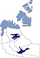
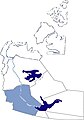
Verwaltungsregionen der Nordwest-Territorien in Kanada[edit]
-
 NWT-Karte von NordNordWst mit Regionsgrenzen
 -
 de:Inuvik Region innerhalb der NTW
 -
 de:Dehcho Region innerhalb der NWT


Hallo NNW, ware es Dir möglich, aus Deiner NWT-Karte fünf Regionskarten zu machen, jeweils mit einer Region hervorgehoben, für die einzelnen Regionenartikel? Oder alternative eine kunterbunte Regionenkarte mit Regionsnamen. Es gibt zwar für zwei der Regionen schon Karten, aber mit denen ist kein Schönheitspreis zu gewinnen (siehe oben Karten der Regionen Inuvik und Dehcho). Danke, und schönen Gruß,--Ratzer (talk) 12:00, 10 May 2014 (UTC)
- Das soll ich wohl hinbekommen. NNW 17:21, 11 May 2014 (UTC)
- Nein, irgendwie doch nicht. Die Positionskarte zeigt sechs Regionen, es sollen aber nur fünf sein. Die Links in den Artikeln führen alle zu Error 404 und ich habe gerade keine Zeit, das zu recherchieren. Wenn du mir einen Link auf eine korrekte Darstellung der Regionen geben kannst, mache ich gerne weiter. NNW 18:30, 16 May 2014 (UTC)
- Diese Karte hier scheint zu passen. Wenn Du von sechs Regionen auf Deiner Poskarte sprichst, meinst Du wohl das enklavenartige Gebilde innerhalb der North Slave Region, ueber das ich mich auch schon gewundert habe. Weil ich aber nicht weiss, worum es sich dabei handelt (vielleicht die Grenze irgendeines Parks oder Schutzgebiets), hatte ich auch keine Anmerkung dazu gemacht. Gruss,--Ratzer (talk) 23:10, 22 May 2014 (UTC)
- Die Karte habe ich auch gefunden, aber „Touristregionen“ fand ich nicht zielführend. Ich werde wohl Flappiefh, den Urheber, fragen müssen. NNW 07:48, 23 May 2014 (UTC)
- Hier habe ich noch eine Karte gefunden, mit den bekannten Grenzen, aber nur drei oder vier der Regionen so bezeichnet. Noch nicht ganz am Ziel... Grüße,--Ratzer (talk) 09:11, 12 June 2014 (UTC)
China location maps[edit]
Hello. I saw you made a few maps the location of China. Will you complete the work, and prepare maps missing: Anhui, Gansu, Zhejiang, Guizhou, Jiangsu, Jiangxi, Hebei, Henan, Hunan, Shaanxi, Shanxi, Guangxi and Ningxia. Thank you very much, Carlos (talk) 17:54, 13 May 2014 (UTC)
- First of all I have to complete the four missing maps for Norway. NNW 18:54, 13 May 2014 (UTC)
- Excellent. Thank you. Carlos (talk) 19:05, 13 May 2014 (UTC)
Kosovo[edit]
Kosovo prikazivaš u sklopu Srbije a Krim u sklopu Rusije. Očigledno da si neki umišljeni glumac. Država u kojoj živim je priznala neovisnost Kosova kao i većina država Evropske unije pa prema tome tako bi se i trebao ponašati zar ne? Wikipedija nije skladištenje mapa nekih pojedinih umišljenih balavaca! Golden Bosnian Lily (talk) 16:55, 14 May 2014 (UTC)
An interactive map of Wikipedia Education Programs for Outreach wiki[edit]
Hello NNW,
What a beautiful moth on your user page! :)
I'm writing to you because I'm in need of the expertise of a mapmaker.
I saw your name in a list "influential Wikipedia cartographers" mentioned by User:Yug and User:Planemad in their IEG proposal for the Wikimaps Atlas project.
I'm on the WMF's global education team, and some of our community members have asked us to add a map of educational programs on education.wikimedia.org. We'd like to have this, too; and we'd especially like to have it be an interactive map, like this one used by Wiki Loves Monuments here.
I've submitted a map request on the Wikipedia:Graphics Lab/Map workshop. But that process could take quite a while and it isn't guaranteed. So they suggest proposing a direct collaboration with a mapmaker using his talk page to request special maps.
I wanted to reach out to you because of your colleagues' recommendations and, I must admit, because I liked your user name. :) It reminded me of that line in Master and Commander: "Aye, sir, sou'-sou'west."
Do you know anyone in the cartography community who might want to participate in this? Could you possibly help us with this? I'm really hoping so! :)
All the best to you, Anna Koval (WMF) (talk) 22:58, 15 May 2014 (UTC)
- Hello! I didn't know that I was "influential". And there are some users who definitely ignore this. :o) A map like Commons:Wiki Loves Monuments 2012 in the United States/Get Started is quite simple. First of all Outreach needs the ImageMap extension. I don't know if it is installed there. Then I need a list of countries with educational programs and the correct links to the program pages. The rest is just a routine piece of work. You want to use File:BlankMap-World gray.svg? Best regards, NNW 08:10, 16 May 2014 (UTC)
- NNW, I literally did a happy dance when I read your reply to me here! You completely made my day! :)
- I'm thrilled that you think that this is doable and simple and I can't wait to get started!
- Outreach wiki does have the ImageMap extension -- see outreach:Special:Version.
- Here are the countries where we have education programs, and so they would need special coloration:
- Algeria Argentina Armenia Australia Austria Azerbaijan Bangladesh Belgium Bolivia Brazil Cameroon Canada Catalonia (Amical) Chile Colombia Czech Republic Denmark Ecuador Egypt Estonia Finland France Germany Greece Honduras Hong Kong Hungary India Indonesia Ireland Israel Italy Japan Jordan Kazakhstan Kenya Korea Macedonia Mexico Myanmar Namibia Nepal Netherlands Norway Panama Philippines Poland Portugal Qatar Russia Saudi Arabia Serbia Singapore Slovakia South Africa Spain Sweden Switzerland Taiwan Thailand Tunisia Ukraine United Kingdom United States Uruguay Venezuela Yemen
- At first I was thinking that we'd only need to be able to click on (interact with) only the countries where we currently have educational programs. But if it's possible to make all countries clickable, that would be even better. Clicking on those countries would lead to a page that says something like: "There's no Wikipedia Education Program in this country yet. But you can help us start one! Here's how..." So. if there is an education program in a country, it would be one color, a bright bold color, and clicking it would lead to it's program description page. If there isn't an education program in a country yet, it would be another color, a lighter color, like gray or white, and would lead to that no-program-yet page I described. Does that make sense? :)
- File:BlankMap-World gray.svg is okay. That was just the first svg file that I found. If you have a better one in mind, we're open to just about anything. Except one where the ocean is black; that look can seem kind of stark and I'm not sure how well it would look on our all-white wiki. But other than that, we'll rely on your expertise in these matters! :)
- Just a head's up, I did hear back from the Wikipedia:Graphics_Lab. Not sure if/when they'll be able to help us. They encouraged us to pursue "other approaches," which may be faster. I think and I hope that's what we're doing here! :)
- Just one last thing: I didn't say you were influential; Yug did. But seeing you in action so far, I'm inclined to believe him! ;)
- Thank you, NNW, so so much! Anna Koval (WMF) (talk) 20:05, 17 May 2014 (UTC)
- Hello NNW! I was thinking about file:BlankMap-World6.svg for this request, since it takes more attention and monitoring. I answered to Anna on the Graphic lab, and I was actually suggesting imagemap (quicker). I have no experience myself, however, on this, and ignore if this tool the suitable one. Yug (talk) 21:28, 18 May 2014 (UTC)
First step: the map. Btw: please correct "unterstützen" (additional t) at https://outreach.wikimedia.org/wiki/Main_Page/de. NNW 13:31, 19 May 2014 (UTC)
@Anna: Second step: ImageMap with links for countries with programs: https://outreach.wikimedia.org/wiki/User_talk:NordNordWest. The rest of the countries can come later. NNW 17:51, 19 May 2014 (UTC)
- NNW, thank you thank you thank you thank you thank you thank you thank you for the map and the imagemap! I'll get back to you soon about the other countries. For now, know that you really helped someone and you made someone very happy! :) (Note: someone = me) Mit freundlichen Grüßen, Anna Koval (WMF) (talk) 20:48, 21 May 2014 (UTC)
- In case you didn't see this here, just a quick question. Thanks, NNW! Anna Koval (WMF) (talk) 21:07, 21 May 2014 (UTC)
Karten zum Mährerreich[edit]
Hallo NordNordWest, ich habe zu den von dir erstellten Karten zum Mährerreich eine nachträgliche Bitte:
- Streiche die Bezeichnung "Lausitz" und dehne dafür im Gebiet oberhalb von Meißen die Bezeichnung "Sorben" von Merseburg in einem Bogen nach unten bis an die heutige Ostgrenze Deutschlands aus (dort, wo die Sorben jetzt auf den Karten angegeben sind).
- Ergänze bitte unterhalb der Bezeichnung "Böhmen" in kleinerer Schrift und in Klammer "(Tschechen)".
Gruß --Trimnapaschkan (talk) 22:04, 17 May 2014 (UTC)
- Moin! Die Karten sind jetzt überarbeitet. Viele Grüße, NNW 15:19, 18 May 2014 (UTC)
- Super, danke dir! Gruß --Trimnapaschkan (talk) 20:03, 18 May 2014 (UTC)
Autokennzeichen[edit]
Hallo NordNordWest, ich bin Juri-der-Russe und habe in der Liste der Kennzeichen auf https://de.wikipedia.org/wiki/Liste_der_Kfz-Kennzeichen_in_Deutschland zahlreiche Ergänzungen vorgenommen, vor allem für Kennzeichen ehemaliger Landkreise im Land Brandenburg, bin aber nicht in der Lage, dieses auf der Karte einzutragen. Wie kann man da Abhilfe schaffen? Gruesse Juri-der-Russe
- Moin! Deine Änderungen an de:Liste der Kfz-Kennzeichen in Deutschland wurden rückgängig gemacht. Die Karte zeigt nur solche Kennzeichen, die tatsächlich auch in Gebrauch sind, nicht solche, die es mal gab, aber nicht mehr verwendet werden. Dabei greife ich auf Änderungen von de:Vorlage:Metadaten Kfz-Kennzeichen DE zurück. Viele Grüße, NNW 07:53, 23 May 2014 (UTC)
map creation how-to in English?[edit]
Hello. I noticed lots of nice maps on your page: https://commons.wikimedia.org/wiki/User:NordNordWest/Gallery/Location_maps Is there a how-to guide in English for making similar maps, along with setting them up to add pushpins (e.g., see Madrid)? In particular, I'd to see maps for U.S. cities (e.g., https://en.wikipedia.org/wiki/Helena,_Montana). I found a U.S. map for this purpose (https://en.wikipedia.org/wiki/Module:Location_map/data/United_States/doc), but it's too big IMO. I think a separate map for each state (with perhaps some surrounding states including in each state map) would be more appropriate. Thanks. Nearwater (talk) 16:17, 28 May 2014 (UTC)
- As far as I know there is no how-to guide. All you need is a map in an en:equirectangular projection and you need to know the exact degrees of the edges of this map. If you don't know them you can find it out by importing this map as an overlay to Google Earth. This might be a bit tricky for the first time but it is quite simple. For location maps of small areas like towns or small island you can also take OpenStreetMap. This is no equirectangular projection but the difference between these projections can be neglected for small areas. Btw location maps for all US states already exist if you want to show the location of a town, see en:Category:United States location map templates. If you want to show the location of an object inside a town there is the GeoHack at the top of an article. In most cases this is the better – and easier – way to show a location. For example I don't know Jacksonville, so en:Template:Location map United States Jacksonville wouldn't help me to show me a location. With the GeoHack I am able to zoom out and in until I got it. NNW 10:57, 29 May 2014 (UTC)
Gouvernorate von Ägypten[edit]
-
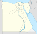 neuere Verwaltungskarte
 -
 ältere Karte (hier Red Sea bzw. offiziell al-Bahr al-ahmar)
 -
 bunte Verwaltungskarte, leider ohne Nil
 -
 bitte auch hier neue Grenzen, vielen Dank


_laea_location_map.svg&action=edit&redlink=1)
_laea_location_map.svg&action=edit&redlink=1)
_laea_location_map.svg&action=edit&redlink=1)
![[1]](https://commons.wikimedia.org/w/index.php?title=File:Israel_location_map.svg&diff=106195116&oldid=106169137)
![[2]](https://commons.wikimedia.org/w/index.php?title=File:Israel_location_map.svg&diff=106271006&oldid=106198677)
Hallo NNW, ich schon wieder. Inzwischen bin ich in Ägypten unterwegs und beschäftige mich mit den Verwaltungseinheiten. Dabei ist mir aufgefallen, dass es ca. 2011 eine ziemlich drastische Verschiebung von Verwaltungsgrenzen gegeben haben muss, indem die Grenzen mehrerer Nil-basierter Gouvernorate weit in die Wüste verschoben und die Wüsten-Gouvernorate entsprechend zurechtgeschnipselt wurde. Hast Du dazu genauere Unterlagen? Wie Du selber siehst, passen die beiden von Dir angefertigten Karten deshalb nicht mehr zusammen (die Vorgängerversion der ersten Karte dagegen hat noch die alten Grenzen).
Leider ist commons voll von Karten nur mit den alten Grenzen, z.B. diese und diese Kategorie. Diese sollen ja nicht weggeworfen werden, denn auch frühere Verwaltungsgrenzen haben ihre Berechtigung in der WP, aber entsprechende Karten mit den neuen Grenzen werden dringend benötigt. Eine aktuelle bunte Verwaltungskarte habe ich gefunden, siehe dritte Karte oben, nur leider ohne Nil (iss auch nix). Vorschläge, wie so ein Projekt aufzuziehen wäre? Selber kann ich hier mangels jeglicher Erfahrung mit Kartographieprogrammen kaum etwas beitragen (will das aber irgendwann mal lernen), andererseits kann ich auch nicht erwarten, dass Du das alles alleine stemmst.
Ich habe bereits einen Kartenwunsch für die Gemeindegrenzen des Gouvernements Matruh eingetragen (bei dem haben sich die Grenzen nicht sichtbar geändert), aber ähnliche Kartenwünsche für Red Sea oder New Valley müssen wohl warten, bevor hier mal die grundlegenden Verwaltungskarten zusammenpassen, zumal auch die Kartenvorlagen für die Gemeindegrenzkarten nur auf Grundlage der neueren Grenzen verfügbar sind. Grüße,-Ratzer (talk) 20:55, 28 May 2014 (UTC)
- Ich habe die Positionskarte letztes Jahr verändert, nachdem jemand Änderungen angemerkt hat, allerdings muss ich sagen, dass ich eigentlich nicht sonderlich glücklich damit bin. Vernünftige Quellen gibt es nicht, hin und wieder Karten aus Zeitungen, die sich in Einzelheiten widersprechen. Karten aus Commons sind in der Regel keine ernst zu nehmenden Quellen. Solange ich nicht eine auch nur halbwegs offizielle Karte sehe, möchte ich im Moment eigentlich nicht an die Karten, auch nicht an meine alten Gouvernementskarten. Vielleicht hatten die Zeitungen gar nicht recht mit diesen neuen Grenzen. Mir fehlt es im Moment an Zeit, eine Quelle zu recherchieren, bin gerade mit den Gemeindeänderungen in Mecklenburg-Vorpommern beschäftigt und das betrifft mehr als 700 Karten plus Artikel plus Commons-Kats. Wenn du mir eine vernünftige Quelle besorgst, können wir schauen, was geht, ansonsten kann ich im Moment nichts machen. Viele Grüße, NNW 10:42, 29 May 2014 (UTC)
- Es ist schon bedauerlich, wenn man zu teilweise drastischen Grenzverschiebungen, die man aufgrund der unterschiedlichen Karten zu erkennen glaubt, keinerlei Unterlagen online findet. Aber vielleicht liegt das auch an unserem Analphabetismus, was die arabische Sprache angeht.
- Deine Forderung nach "halbwegs offiziellen" oder sogar durchaus offiziellen Karten kann ich aber schon zufriedenstellen. Wobei ich unter "offiziell" verstehe, was unter der Domain gov.eg zu finden ist:
- Dazu passt dann auch gleich mal die offizielle Gemeindegliederungskarte des de:Gouvernement al-Bahr al-ahmar (Rotes Meer) auf dieser Seite, quasi als Vorlage für meinen nächsten geplanten Kartenwunsch in der de-WP:KW. Die Karte dort ist zwar etwas arg klein, aber das gleiche in höherer Auflösung ist von Citypopulation.de abzurufen, welches sich seinerseits auf CAPMAS beruft (wo ich selber aber diese Karten nicht gefunden habe).
- Schönen Gruß,--Ratzer (talk) 20:20, 29 May 2014 (UTC)
![[3]](http://www.giza.gov.eg/country%20map/DocLib/Egypt.png)
![[4]](http://www.benisuef.gov.eg/art/egy_govs/egypt_map.png)
- Ja doch, auch auf den CAPMAS-Seiten sind die neuen (?) Gouvernoratsgrenzen zu finden. Hochoffizieller geht's nun wirklich nicht mehr. Gruß,--Ratzer (talk) 05:53, 30 May 2014 (UTC)
- Nach weiteren Beweisen hast Du ja nicht mehr gefragt, aber im Zuge ganz anderer Recherchen bin ich über diese auch quasi amtliche Karte der Schutzgebiete in Ägypten gekommen, die auch die neueren Gouvernoratsgrenzen zeigt. Aber keine Eile, Mecklenburg kommt zuerst. Grüße,--Ratzer (talk) 08:03, 5 June 2014 (UTC)
Gerade konnte ich auf einem Nebenkriegsschauplatz feststellen, dass Kollege Roland Unger genaueres weiß zu den Grenzänderungen der Gouvernements (er erwähnte einen Präsidentenerlass 114/2008 und einen Erlass des Obersten Rats der Streitkräfte 63/2011). Gruß,--Ratzer (talk) 09:46, 5 June 2014 (UTC)
- Die Karten sind jetzt in Category:SVG locator maps of governorates in Egypt (red location map scheme) zu finden. Sie folgen TUBS’ Namensschema mit dem Zusatz „(2011)“. Auf die ganzen Versionen mit den umstrittenen Gebieten habe ich verzichtet. NNW 20:37, 6 June 2014 (UTC)
- Besten Dank! Die erste ist bereits hier eingebaut. Grüße,--Ratzer (talk) 21:36, 6 June 2014 (UTC)
- Vergiss nicht die Imagemap zu ändern. NNW 09:25, 7 June 2014 (UTC)
- Kannst Du mir kurz erklären, was und wie hier zu ändern ist? Gruß,--Ratzer (talk) 15:52, 8 June 2014 (UTC)
- Und noch 'ne Bitte: neue Grenzen auch auf der Relief-Poskarte, vielen Dank.--Ratzer (talk) 16:14, 8 June 2014 (UTC)
- Vergiss nicht die Imagemap zu ändern. NNW 09:25, 7 June 2014 (UTC)
- Du musst mit http://toolserver.org/~dapete/ImageMapEdit/ImageMapEdit.html?de alle Flächen, die sich verändert haben, neu nachzeichnen und in die Imagemap kopieren. Die Reliefkarte ist eine Bilddatei, das wäre sehr viel Retusche für mich. Sprich am besten Sting direkt an, er müsste es fix machen können. NNW 17:24, 8 June 2014 (UTC)
- Beim Kollegen Sting habe ich mich schon gemeldet. Die Sache mit der Imagemap muss ich mir später anschauen. Nur wenn ich von "Flächen neu nachzeichnen" lese, muss ich mich etwas wundern, dass das nicht automatisiert abgehen kann, da sie bzw. ihre Grenzen schon mal gezeichnet wurden.--Ratzer (talk) 11:03, 10 June 2014 (UTC)
- Irgendwo habe ich gelesen, dass es dafür auch ein Tool geben soll, dass die Flächen direkt aus dem SVG herausholt, aber dafür musste man irgendwas bei sich installieren, das war mir schon zu kompliziert, zumal die Flächen für Imagemaps nicht annähernd so genau sein müssen wie im SVG. Das Nachzeichnen geht recht fix und die Datenmenge ist dadurch deutlich kleiner. NNW 13:41, 10 June 2014 (UTC)
markAdmins[edit]
Hallo NNW, wärst du damit einverstanden, User:NordNordWest/markAdmins.js nach MediaWiki:Gadget-markAdmins.js zu verschieben und das, wie auf de auch, zu einem Gadget zu machen? --Didym (talk) 19:20, 7 June 2014 (UTC)
- Moin! Ich habe keine Ahnung, wie man daraus ein Gadget macht, ob man da noch was vom Quelltext ändern muss oder nicht, aber du kannst das gerne in die Hand nehmen. NNW 10:14, 8 June 2014 (UTC)
- Ich habe mal alles notwendige gemacht. Die Seite befindet sich nun hier. Das bei dir jetzt nicht mehr laufende Script kannst du in den Einstellungen wieder aktivieren. --Didym (talk) 12:46, 8 June 2014 (UTC)
San-Tome ...[edit]
Hello. Make a new map for this. It have a wrong place for islands Pedras-Tinhosas (look this and this). Thanks. --Вальдимар (talk) 13:47, 17 June 2014 (UTC)
- Hello! It is corrected now. NNW 15:27, 17 June 2014 (UTC)
- Thanks. --Вальдимар (talk) 05:10, 18 June 2014 (UTC)
China location maps[edit]
Hi, NNW, please help to make the other provincial-level location maps of China, including: Anhui, Beijing,  , Guangxi, Guizhou, Hebei, Henan, Hunan, Jiangsu, Jiangxi, Ningxia, Shaanxi,
  , Shanxi, Tianjin, Zhejiang. Thanks. --千里走单骑 (talk) 01:37, 21 July 2014 (UTC)
- Hello! Unfortunately I am very busy so I cannot promise anything. NNW 07:41, 22 July 2014 (UTC)
- OK, thanks for your reply, please consider it when you would feel free. 千里走单骑 (talk) 00:34, 23 July 2014 (UTC)
Oberwerrieser Mersch[edit]
danke fürs Einsortieren! Hatte deine Bilder nur in der BKL-Kategorie zwischengeparkt weil ich noch an ein paar anderen saß. Jetzt brauch ich dich gar nicht mehr fragen, wo du die Aufnahmen gemacht hast :) Holger1959 (talk) 18:05, 7 August 2014 (UTC)
Education outreach map[edit]
Thanks for correcting Bulgaria on the map. I knew there was something wrong, but only when I saw your edit I realized what it was :))) Many thanks again. →Spiritia 08:38, 10 August 2014 (UTC)
China location maps[edit]
Hi! I was working on some China-related articles on svwiki, and I noticed that you have created the File:China Fujian2 location map.svg, File:China Shandong location map.svg as well as many other useful location maps pertaining to China. I wonder if you have any plans of creating more location maps so we have complete coverage from Chinese province level jurisdictions? They would be badly needed, in my humble opinion, and right now, I'm need of Jiangsu, Henan and Zhejiang provinces. Let me know what you think. --Bothnia (talk) 17:01, 12 August 2014 (UTC)
- Hello! Just look three threads earlier here on my disc. :o) NNW 17:47, 12 August 2014 (UTC)
- OK, sorry to repeat the discussion. Looking forward to the maps whenever you feel like creating them!--Bothnia (talk) 12:17, 13 August 2014 (UTC)
Wiki Loves Monuments 2014 startet in Kürze[edit]

Hallo NordNordWest,
in Kürze ist es wieder soweit. Der nun schon traditionelle Fotowettbewerb Wiki Loves Monuments wird im September zum vierten Mal stattfinden. In ähnlicher Form hatte unlängst der Wettbewerb "Wiki Loves Earth" eine erfolgreiche Premiere. Zu allen bisherigen vier Wettbewerben haben seit 2011 gut 3000 unterschiedliche Teilnehmer (User) ihren Beitrag geleistet. Du warst dabei, und bist auch herzlich eingeladen, am bevorstehenden WLM-Wettbewerb wieder dabei zu sein.
Allein in Deutschland wurden in den letzten drei Jahren im Rahmen von WLM rund 100.000 Fotos zu den insgesamt ca. 850.000 Kulturdenkmalen bundesweit hochgeladen. Jährlich haben sich mehrere Hundert Wiki-Fotographen daran beteiligt. Auch im kommenden Denkmalmonat wird dies gewiss wieder der Fall sein. Der Tag des offenen Denkmals am 14. September bietet bundesweit vielfältige Möglichkeiten, Denkmale nicht nur von außen, sondern auch von innen zu fotografieren. Denkmallisten sind dabei ein wichtiger Orientierungspunkt und zugleich auch Ziel der Einbindung der Fotos. Auch in diesem Jahr sind wieder neue Denkmallisten hinzugekommen, die hilfreich bei der Planung von individuellen oder Gruppen-Fototouren sind und auf eine Bebilderung warten, wie z.B. zu Görlitz oder Zittau. Unter den Landeshauptstädten fehlt nur noch Stuttgart. Aber auch hier ist Licht in Sicht.
In der Mitte Deutschlands hat die Denkmallandschaft der thüringischen Landeshauptstadt Erfurt nun das Licht der Wikipedia-Welt entdeckt. Mehr als 50 Tabellen enthalten 3.700 Denkmale. Allein die wunderschön restaurierte Altstadt umfasst 1.800 Denkmale. Eine von WMDE geförderte WLM-Fototour nach Erfurt am Wochenende vom 29. – 31. August lädt herzlich ein, diese einzigartige Kulturlandschaft zu dokumentieren. Mehr Informationen findest Du auf der Projektseite.
Wir freuen uns auf Deine weiteren Beiträge für Wikimedia-Projekte.
Viel Spaß beim größten Fotowettbewerb der Wiki(m/p)edia wünscht Dir das Orga-Team.
( Bernd Gross, 16. August 2014)
Ukraine location map[edit]
Ahonc, a Ukrainian user with pro-Ukrainian views has once again vandalized the location map of Ukraine by making Crimea once again an integral part Ukraine, which it's not. Can you please once again fix this. If the user continues to push pro-Ukrainian POV I think he has to be reported. --Leftcry (talk) 16:29, 6 September 2014 (UTC)
- The file is protected for a week. To be honest I don't care. I'm about to start a new series of location maps which are defined as de facto maps. It is senseless to invest more time in discussions with persons who have never made any location map or even discussed them until it concerns their own countries. Wikipedia is my hobby, I'm sick of spending time with POV pushers. NNW 18:09, 6 September 2014 (UTC)
- I greatly respect all your work for maps however this issue with the location map of Ukraine must be solved as the file is used in many articles. I think I will have to report the POV pushing user that reverted the map to what it is now as I don't see another way to stop him from pushing his POV. --Leftcry (talk) 18:14, 6 September 2014 (UTC)
- Most location maps are used via templates, so you just have to change the file in the template: one edit. I am sure German Wikipedia prefers location maps which show the de facto reality, not a wishlist. If there are other projects which think so, too, it's fine but I won't discuss it. NNW 20:25, 6 September 2014 (UTC)
- I greatly respect all your work for maps however this issue with the location map of Ukraine must be solved as the file is used in many articles. I think I will have to report the POV pushing user that reverted the map to what it is now as I don't see another way to stop him from pushing his POV. --Leftcry (talk) 18:14, 6 September 2014 (UTC)
There is a new file now: File:Ukraine adm location map.svg. A bit different in style which eliminates the inexactness with the use of light grey, rivers for European countries, too, and some other minor changes. Best of all: defined as de facto. NNW 11:44, 7 September 2014 (UTC)
- The original location map returned its de facto depiction so it can be returned. --Leftcry (talk) 21:49, 26 September 2014 (UTC)
- I don't believe that the reverts have come to an end. :o) NNW 22:00, 26 September 2014 (UTC)
- I know, it finally happened. A user protected the file so that only administrators can edit it therefore I think the POV pushing will finally come to an end :) I also wanted to ask you what you're thinking about the Georgia location map as well as the location maps of a few other countries. I know you said you have a new set of location maps coming up, how is that going? --Leftcry (talk) 22:08, 26 September 2014 (UTC)
- I started with the new series. NNW 22:32, 26 September 2014 (UTC)
- I know, it finally happened. A user protected the file so that only administrators can edit it therefore I think the POV pushing will finally come to an end :) I also wanted to ask you what you're thinking about the Georgia location map as well as the location maps of a few other countries. I know you said you have a new set of location maps coming up, how is that going? --Leftcry (talk) 22:08, 26 September 2014 (UTC)
- I don't believe that the reverts have come to an end. :o) NNW 22:00, 26 September 2014 (UTC)
- The original location map returned its de facto depiction so it can be returned. --Leftcry (talk) 21:49, 26 September 2014 (UTC)
A barnstar for you![edit]

|
The Graphic Designer's Barnstar |
| Klasse Karten - insbesondere die Lübecker Landwehrkarte DerVermesser (talk) 22:24, 13 September 2014 (UTC) |
- Vielen Dank! NNW 07:01, 14 September 2014 (UTC)
Bundesländer auf Karte markieren[edit]
Hallo,
kannst Du mir vielleicht sagen wie Du folgende Karte erstellt hast? de:Datei:Locator map Mecklenburg-Vorpommern in Germany.svg
Vom Gefühl her würde ich vermuten, dass Du einfach File:Germany location map.svg gennommen hast und die entsprechende Fläche von MacPom mit einem Grafikprogramm rot gefüllt hast.
Falls ja wäre es auch interessant zu wissen, welches Programm Du benutzt hast.
Gruß--EbenezerScrooge (talk) 15:00, 9 October 2014 (UTC)
- Moin! Schau mal unter de:Benutzer_Diskussion:NordNordWest/Archiv7#Hilfe, da hatte ich dir schon geantwortet. Viele Grüße, NNW 08:28, 13 October 2014 (UTC)
Hello, as you are the one who made this map, can I ask you to change it according to the official map (from Central of Statistics & Information), because the current map based on an old data and now the domestic region borders have been changed. thank you. --MrJoker07 (talk) 15:28, 13 October 2014 (UTC)
- Hello and thanks for the link. I will update that map in the following days. NNW 15:53, 13 October 2014 (UTC)
- Thank you. MrJoker07 (talk) 16:13, 13 October 2014 (UTC)
@ MrJoker07 & TUBS: There is a new file:Saudi Arabia adm location map.svg available now which shows the new region boundaries. NNW 17:40, 14 October 2014 (UTC)
- It is perfectly done, thank you. -- MrJoker07 (talk) 19:01, 14 October 2014 (UTC)
- updated both locator and admin maps.
 Done Thx again for telling me/us. --TUBS 10:09, 15 October 2014 (UTC)
- updated both locator and admin maps.
Wikimapia[edit]
Hallo NNW, warum darf de:Wikimapia nicht hochgeladen werden wenn sie laut Wikipedia die Daten doch frei sind? Die erfassten Daten werden seit 2012 unter der freien Lizenz CC-BY-SA angeboten--Bux123 (talk) 15:16, 14 October 2014 (UTC)
- Moin! Das Problem ist die Kombination aus „erfassten Daten“ und Luft-/Satellitenbild. Die „erfassten Daten“ sind die farbigen Linien, die über dem Luftbild zu sehen sind und die sind unter Creative Commons gestellt. Das betrifft aber nicht die Bilddaten. Wenn du auf Wikimapia gehst, wirst du unten das © für die „Grafiken“ finden, wie dort die Bilddaten genannt werden. Ansonsten könnte man ja auch gleich einen Google-Maps-Screenshot hochladen, denn von dort werden die Bilddaten bezogen, siehe unten links. Viele Grüße, NNW 15:28, 14 October 2014 (UTC)
Moin NNW, könntest du bitte die Sophienterrasse "schließen"? Danke schonmal! --Flor!an (talk) 10:42, 21 October 2014 (UTC)
- Schon wieder eine Karte, an die ich mich nicht mehr erinnern konnte. :o) Ist jetzt aktualisiert, danke für den Hinweis. NNW 19:12, 21 October 2014 (UTC)
Sweden map request[edit]
Hi, I'm a user mainly active over at the English Wikipedia. I noticed that you are the creator of File:Sweden location map, 40south.svg. This map has been used for a lot of the Allsvenskan season articles such as 2014 Allsvenskan, but for the 2015 Allsvenskan article we have a team (Sundsvall) which is located north of the 40south map, therefore the entire Sweden location map is being used. This makes for some messy layout issues as the majority of the teams linked on the map are located south of Stockholm. I wonder if you could possibly create a location map that cuts out right above Sundsvall? Thanks! --Reckless182 (talk) 15:54, 11 November 2014 (UTC)
- Hello, it wasn't me but User:Lokal Profi who made File:Sweden location map, 40south.svg but now there is File:Sweden South adm location map.svg, too. NNW 18:30, 11 November 2014 (UTC)
- Ah, sorry about the confusion! Thank you very much, that looks perfect! I'm experiencing some diffculties implementing it though, I get an error that says "Lua error in Module:Location_map/multi at line 13: Unable to find the specified location map definition. Neither "Module:Location map/data/Sweden South adm" nor "Template:Location map Sweden South adm" exists." Do I have to create a template on Wikipedia? --Reckless182 (talk) 20:50, 11 November 2014 (UTC)
- Yes, you have to create a new template with the coordinates given in the file description. NNW 20:55, 11 November 2014 (UTC)
- Apparently I don't have permission to create a template named "Template:Location map Sweden South am". It rather tells me to create a module called "Module:Location map/data/Sweden South adm" instead. Is this something that you are experienced with? I must confess that I have no knowledge regarding module creating. --Reckless182 (talk) 21:03, 11 November 2014 (UTC)
- Nevermind, I think I managed. --Reckless182 (talk) 21:10, 11 November 2014 (UTC)
Nuovo Trasporto Viaggiatori map (Italy): upgrading request[edit]
Hello, can you upgrade the Nuovo Trasporto Viaggiatori map, please? There are 4 new stations to add: Reggio Emilia AV Mediopadana + Rimini, Pesaro and Ancona (on Bologna–Ancona railway). Thanx --Holapaco77 (talk) 20:03, 12 November 2014 (UTC)
- Hello! No problem, it's corrected now. NNW 21:45, 12 November 2014 (UTC)
Netflix availability: upgrading request[edit]
Hi, with the latest launch Netflix is also available in the South American countries of Guyana, Suriname and French Guiana, in the entire Caribbean, except Cuba, in Greenland in the North Atlantic and even several locations in the Pacific Ocean, like Guam and Palau. You can see all the countries where Netflix is available on this page: https://help.netflix.com/en/node/14164 Could you please upgrade your Netflix area map? Thanks. --Wikola (talk) 12:52, 15 November 2014 (UTC)
- Thanks for the hint. The map is updated now. NNW 13:12, 15 November 2014 (UTC)
U5 Hamburg[edit]
Hallo NordNordWest, magst Du in die sehr informative Karte zur geplanten U5 in Hamburg noch die bestehenden DESY-Tunnel mit aufnehmen? Der HERA-Tunnel, um den es im Wesentlichen geht, ist in openstreetmaps vorhanden. Viele Grüße — Preceding unsigned comment added by 84.130.193.110 (talk • contribs)
- Moin! Ich verstehe nicht ganz, was HERA mit der U5 zu tun hat. HERA stört die Planung von der Strecke nicht, da sie stillgelegt ist. Das Problem an DESY sind – soweit ich weiß – die dort stattfindenden Messungen, die in möglichst ruhiger Umgebung stattfinden müssen. Viele Grüße, NNW 18:31, 27 November 2014 (UTC)
Deutschlandkarte Landschaften[edit]
Hallo NordNordWest,
ich würde gerne eine Ihrer Karten in einer Zeitschrift verwenden, blicke aber bei den Nutzungsbestimmungen von Wikipedia nicht wirklich durch. Bitte kontaktieren Sie mich. Danke im Voraus!
MfG Jurixe
- Hallo! Ich habe Ihnen per Mail geantwortet. NNW 14:45, 18 December 2014 (UTC)
Karten von der autonomen Region Kurdistan[edit]
Hallo NordNordWest, würde es dir was ausmachen eine physische bzw. eine Standardkarte von der Autonomen Region Kurdistan zu erstellen? Etwa so eine, wie du bereits von Sizilien (Wiki-De: Vorlage:Positionskarte Italien Sizilien) erstellt hast. Würde mich sehr freuen. MfG und schöne Feiertage --Moplayer (talk) 01:08, 25 December 2014 (UTC)
Reliefkarten Bundesländer Österreichs[edit]
Hallo NordNordWest;
Gratuliere erstmals zu deinen irrsinnig tollen Karten, die du hochgeladen hast. Für mich sind v.a. die Reliefkarten der österreichischen Bundesländer äußerst interessant. Nun hab ich mir bereits 7 Bundesländer runtergeladen wie z.B. https://commons.wikimedia.org/wiki/File:Austria_Styria_relief_location_map.svg Mir gehen nur Oberösterreich und Niederösterreich ab :-( Hast du einen link zu diesen beiden Bundesländern oder eventuell eine hochauflösende Österreichkarte - dann könnte ich sie mir auch selber "ausschneiden".
Liebe Grüße einstweilen und herzlichen Dank chrisettn