User:Giftzwerg 88/Fotoprojekt Kloster Kirchberg
Jump to navigation
Jump to search
| This is a gallery of files created by Giftzwerg 88. |
Dieses ist die Seite von Fotoprojekt Kloster Kirchberg. Obwohl ich angesichts einer Tagung längere Zeit dort war und viel fotografiert habe, erscheint es mir, als hätte ich nur die Hälfte erfasst von dem was für eine einigermaßen vollständige Dokumentation notwendig gewesen wäre.
Kloster Kirchberg bei Nacht[edit]
| Object location | | View all coordinates using: OpenStreetMap |
|---|
Ansichten[edit]
Klostergarten[edit]
| Object location | | View all coordinates using: OpenStreetMap |
|---|
Nonnenempore[edit]
| Object location | | View all coordinates using: OpenStreetMap |
|---|
Konventsgebäude[edit]
| Object location | | View all coordinates using: OpenStreetMap |
|---|
Konventsgebäude innen[edit]
| Object location | | View all coordinates using: OpenStreetMap |
|---|
Klosterladen[edit]
| Object location | | View all coordinates using: OpenStreetMap |
|---|
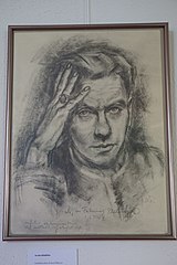
Kurt Reuber[edit]
Reuber war ein Michaelsbruder, sein Andenken wird bewahrt.
Landschaft[edit]
Klosterkirche[edit]
| Object location | | View all coordinates using: OpenStreetMap |
|---|
Nonnenfriedhof[edit]
| Object location | | View all coordinates using: OpenStreetMap |
|---|
Fernaufnahmen[edit]


