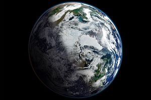
Satellite-based view of the Arctic. The record lowest minimum ever observed in the satellite record occurred on September 16, 2012, when sea ice plummeted to 3.41 million square kilometers (1.32 million square miles). This image shows the area two weeks earlier. The edges of the ice pack are reasonably visible, as are some fractured areas. But some details are obscured by clouds.
This is the English translation of the Picture of the day description page from 21 May 2017.
Satellite-based view of the Arctic. The record lowest minimum ever observed in the satellite record occurred on September 16, 2012, when sea ice plummeted to 3.41 million square kilometers (1.32 million square miles). This image shows the area two weeks earlier. The edges of the ice pack are reasonably visible, as are some fractured areas. But some details are obscured by clouds.