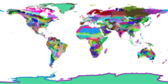
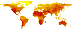
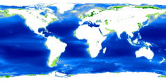
Publicly available global data sets
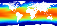
Global maps on our environment (both remote sensing-based and thematic) are nowadays increasingly attractive for environmental modelling. A variety of publicly available maps can be obtained at no cost at resolutions up to 1 km or better. This article archive copy at the Wayback Machine reviews some of the most known global datasets of interest for various environmental modeling projects (see also some similar galleries of world maps by Google Earth archive copy at the Wayback Machine, FAO's GeoNetwork, UNEP/GRID GEO DataPortal archive copy at the Wayback Machine, UNEP/GRID-Arendal archive copy at the Wayback Machine, The Environmental Information Portal archive copy at the Wayback Machine of the World Resources Institute, and/or GeoPortal archive copy at the Wayback Machine).
Use this R script archive copy at the Wayback Machine to automatically download and browse the maps shown below (the script also includes some small exercises to import/export data, set the correct coordinate system, make displays and run geostatistical mapping of point-sampled variables). The total size of maps is about 300 MB (62 maps). Each gridded map consists of 7200 columns and 3600 rows; the cell size is 0.05 arcdegrees, which corresponds to about 5 km. All maps are projected in the Latitude-Longitude WGS84 system +proj=longlat +ellps=WGS84. Displays shown below were produced using the SAGA GIS.
- Publicly available global data sets
-

-

-
-

-

-
-
-

-

-

-
-

-

-
-

-

-

-
-

-
-

-
-

-

-

-

-
-

-

-

-

-
-

-

-

-
-
-

-
-

-

-