Maps of Armenia
Jump to navigation
Jump to search
Countries of Europe: Albania · Andorra · Armenia‡ · Austria · Azerbaijan‡ · Belarus · Belgium · Bosnia and Herzegovina · Bulgaria · Croatia · Cyprus‡ · Czech Republic · Denmark · Estonia · Finland · France‡ · Georgia‡ · Germany · Greece · Hungary · Iceland · Republic of Ireland · Italy · Kazakhstan‡ · Latvia · Lithuania · Luxembourg · Malta · Monaco · Netherlands‡ · North Macedonia · Norway · Poland · Portugal‡ · Romania · Russia‡ · San Marino · Slovakia · Slovenia · Spain‡ · Sweden · Switzerland · Turkey‡ · Ukraine · United Kingdom · Vatican City
Specific status: Faroe Islands · Gibraltar · Isle of Man – Limited recognition: Abkhazia‡ · Kosovo
‡: partly located in Europe
Specific status: Faroe Islands · Gibraltar · Isle of Man – Limited recognition: Abkhazia‡ · Kosovo
‡: partly located in Europe
- Maps are also available as part of the
 Wikimedia Atlas of the World project in the Atlas of Armenia.
-
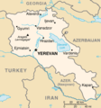
 Location map for Armenia
 -
 Satellite image of Armenia in May 2003
 -
 Map of Armenia


Administrative divisions[edit]
-
 Provinces of Armenia (SVG)
 -
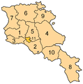 Provinces of Armenia
 -
 Aragatsotn (SVG)
 -
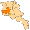 Aragatsotn
 -
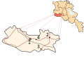
 Ararat (SVG)
 -
 Ararat
 -
 Armavir (SVG)
 -
 Armavir
 -
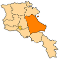 Gegharkunik
 -
 Kotyak
 -
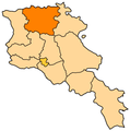 Lori
Lori -
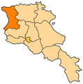 Shirak
 -
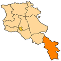 Syunik
 -
 Tavush
 -
 Vayots Dzor


