IBRA
Jump to navigation
Jump to search
English: The Interim Biogeographic Regionalisation for Australia (IBRA) is a biogeographic regionalisation of Australia.
IBRA regions[edit]
Overall regionalisation[edit]

Region location maps[edit]
-
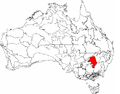
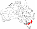
 IBRA regions with Australian Alps region in red
 -
 IBRA regions with Arnhem Coast region in red
 -
 IBRA regions with Arnhem Plateau region in red
 -
 IBRA regions with Avon Wheatbelt region in red
 -
 IBRA regions with Brigalow Belt North region in red
 -
 IBRA regions with Brigalow Belt South region in red
 -
 IBRA regions with Ben Lomond region in red
 -
 IBRA regions with Broken Hill Complex region in red
 -
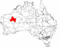
 IBRA regions with Burt Plain region in red
 -
 IBRA regions with Carnarvon region in red
 -
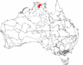
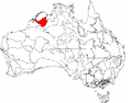
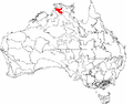
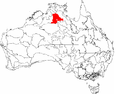
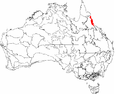
 IBRA regions with Central Arnhem region in red
 -
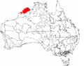
 IBRA regions with Central Kimberley region in red
 -
 IBRA regions with Central Mackay Coast region in red
 -
 IBRA regions with Central Ranges region in red
 -
 IBRA regions with Channel Country region in red
 -
 IBRA regions with Cobar Peneplain region in red
 -
 IBRA regions with Coolgardie region in red
 -
 IBRA regions with Daly Basin region in red
 -
 IBRA regions with Darling Riverine Plains region in red
 -
 IBRA regions with Dampierland region in red
 -
 IBRA regions with Darwin Coastal region in red
 -
 IBRA regions with Davenport Murchison Ranges region in red
 -
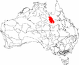
 IBRA regions with Desert Uplands region in red
 -
 IBRA regions with Einasleigh Uplands region in red
 -
 IBRA regions with Esperance Plains region in red
 -
 IBRA regions with Eyre Yorke Block region in red
 -
 IBRA regions with Finke region in red
 -
 IBRA regions with Flinders region in red
 -
 IBRA regions with Flinders Lofty Block region in red
 -
 IBRA regions with Gascoyne region in red
 -
 IBRA regions with Gawler region in red
 -
 IBRA regions with Geraldton Sandplains region in red
 -
 IBRA regions with Gibson Desert region in red
 -
 IBRA regions with Great Sandy Desert region in red
 -
 IBRA regions with Great Victoria Desert region in red
 -
 IBRA regions with Gulf Coastal region in red
 -
 IBRA regions with Gulf Fall and Uplands region in red
 -
 IBRA regions with Gulf Plains region in red
 -
 IBRA regions with Hampton region in red
 -
 IBRA regions with Jarrah Forest region in red
 -
 IBRA regions with Kanmantoo region in red
 -
 IBRA regions with King region in red
 -
 IBRA regions with Little Sandy Desert region in red
 -
 IBRA regions with MacDonnell Ranges region in red
 -
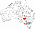
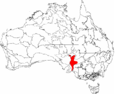
 IBRA regions with Mallee region in red
 -
 IBRA regions with Mitchell Grass Downs region in red
 -
 IBRA regions with Mount Isa Inlier region in red
 -
 IBRA regions with Mulga Lands region in red
 -
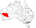 IBRA regions with Murchison region in red
 -
 IBRA regions with Murray Darling Depression region in red
 -
 IBRA regions with Nandewar region in red
 -
 IBRA regions with Naracoorte Coastal Plain region in red
 -
 IBRA regions with New England Tablelands region in red
 -
 IBRA regions with North Kimberley region in red
 -
 IBRA regions with NSW North Coast region in red
 -
 IBRA regions with NSW South Western Slopes region in red
 -
 IBRA regions with Nullarbor region in red
 -
 IBRA regions with Ord-Victoria Plains region in red
 -
 IBRA regions with Pilbara region in red
 -
 IBRA regions with Pine Creek region in red
 -
 IBRA regions with Riverina region in red
 -
 IBRA regions with Simpson Strzelecki Dunefields region in red
 -
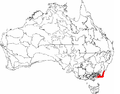
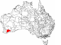
 IBRA regions with South East Coastal Plain region in red
 -
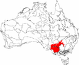
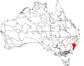
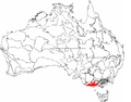
 IBRA regions with South East Corner region in red
 -
 IBRA regions with South Eastern Highlands region in red
 -
 IBRA regions with South Eastern Queensland region in red
 -
 IBRA regions with Stony Plains region in red
 -
 IBRA regions with Sturt Plateau region in red
 -
 IBRA regions with Swan Coastal Plain region in red
 -
 IBRA regions with Sydney Basin region in red
 -
 IBRA regions with Tanami region in red
 -
 IBRA regions with Tasmanian Central Highlands region in red
 -
 IBRA regions with Tasmanian Northern Midlands region in red
 -
 IBRA regions with Tasmanian Northern Slopes region in red
 -
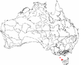
 IBRA regions with Tasmanian South East region in red
 -
 IBRA regions with Tasmanian Southern Ranges region in red
 -
 IBRA regions with Tasmanian West region in red
 -
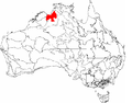
 IBRA regions with Tiwi Cobourg region in red
 -
 IBRA regions with Victoria Bonaparte region in red
 -
 IBRA regions with Victorian Midlands region in red
 -
 IBRA regions with Victorian Volcanic Plain region in red
 -
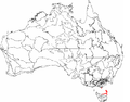
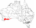
 IBRA regions with Warren region in red
 -
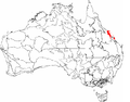
 IBRA regions with Wet Tropics region in red
 -
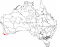
 IBRA regions with Yalgoo region in red


Region detail maps[edit]
-
 Detail of the Esperance Plains region
 -
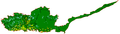
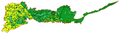 Detail of the Mallee region
 -
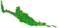 Detail of the Warren region

Subregion location maps[edit]
-
 IBRA subregions with Western Mallee (MAL1) in red
 -
IBRA subregions with Western Mallee (MAL2) in red

Subregion detail maps[edit]
-
 Detail of Eastern Mallee (MAL1) subregion
 -
 Detail of Western Mallee (MAL2) subregion

Beard's Provinces[edit]
These are maps of the three Provinces into which John Stanley Beard divided Western Australia. These provinces pre-date IBRA, but are still in use, and are now defined in terms of IBRA regions.
-
 IBRA regions with regions of the South West Botanical Province in red
 -
IBRA regions with regions of the Eremaean Botanical Province in red
-
IBRA regions with regions of the Northern Botanical Province in red

Hopper's Rainfall Zones[edit]
Stephen Hopper divided the South West Botanical Province into three Rainfall Zones. These zones pre-data IBRA, but are still in use, and the Transitional and High Rainfall Zones are now defined in terms of IBRA regions. The Low Rainfall Zone was never clearly defined, so has not been mapped.
-
 IBRA regions with regions of the Transitional Rainfall Zone in red
 -
 IBRA regions with regions of the High Rainfall Zone in red


Comparisons with other schemes[edit]
