Fogo (Cape Verde)
Jump to navigation
Jump to search
only island of Cape Verde with an active volcano  Letecký pohled  | |||||
| Upload media | |||||
| Instance of | |||||
|---|---|---|---|---|---|
| Part of | |||||
| Location | |||||
| Located in or next to body of water | |||||
| Capital | |||||
| Width |
| ||||
| Length |
| ||||
| Highest point | |||||
| Population |
| ||||
| Area |
| ||||
| Elevation above sea level |
| ||||
 | |||||
-

-
 natural colour satellite image
 -
 3-D image of the island of Fogo from NNE
 -
 Aerial shot
 -
 Chã das Caldeiras and main ash cone, Fogo. NASA satellite image, 2009
 -
 Aerial photo
 -
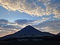 Pico do Fogo
 -
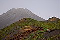
 Main ash cone of Pico do Fogo
 -
 Losma, an endemic medicinal plant
 -
 vineyard
 -
 Pyroclastic Layers of Monte Sambango
 -
 endemic plants in the garden of the Museu Municipal in São Filipe
 -
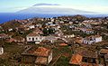
 São Filipe
 -
 Vila Nova Sintra
 -
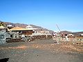 Chã das Caldeiras
 -
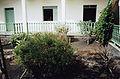
 Jardim Florido, S. Filipe - 1997


.jpg)


