File:Zwenkau Messtischblatt df dk 0000151 4739 1879.jpg

Original file (7,708 × 7,746 pixels, file size: 8.76 MB, MIME type: image/jpeg)
Captions
Captions
Coordinates of map center
Summary
[edit]| Äquidistantenkarte 25 : Zwenkau, 1879
( |
||||||||||||||||||||||||||||||||||||||||||||||||
|---|---|---|---|---|---|---|---|---|---|---|---|---|---|---|---|---|---|---|---|---|---|---|---|---|---|---|---|---|---|---|---|---|---|---|---|---|---|---|---|---|---|---|---|---|---|---|---|---|
| Title |
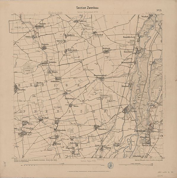
Äquidistantenkarte 25 : Zwenkau, 1879 |
|||||||||||||||||||||||||||||||||||||||||||||||
| Original caption |
Original image description from the Deutsche Fotothek Section Zwenkau, Blatt 25 aus: Topographische Karte (Äquidistantenkarte) Sachsen. |
|||||||||||||||||||||||||||||||||||||||||||||||
| Description |
Deutsch: Das im Jahr 1879 noch als Äquidistantenkarte bezeichnete Messtischblatt mit dem Titel Section Zwenkau. Das gleiche Rechteck wurde im Laufe der Zeit von verschiedenen Institutionen vermessen, die es unter verschiedenen Referenznummern führten:
English: Map survey sheet titled Section Zwenkau, referenced by the numbers 25 (saxon land survey), 320 (first prussian-), 2751 (second prussian land survey), 4739 (two-dimensional index number used from 1937 onwards, still in use today) |
|||||||||||||||||||||||||||||||||||||||||||||||
| Date | 1 September 2013, 21:18:25 | |||||||||||||||||||||||||||||||||||||||||||||||
| Medium | Lithografie & Umdruck | |||||||||||||||||||||||||||||||||||||||||||||||
| Dimensions | 46 x 44 cm Maßstab 1:25000 | |||||||||||||||||||||||||||||||||||||||||||||||
| Collection |
|
|||||||||||||||||||||||||||||||||||||||||||||||
| Notes | Dezoomified losslessly with jpegtran and dezoomify.py | |||||||||||||||||||||||||||||||||||||||||||||||
| Source |
Deutsche Fotothek Permalink |
|||||||||||||||||||||||||||||||||||||||||||||||
| Other versions |
|
|||||||||||||||||||||||||||||||||||||||||||||||

| Detailed information from the Deutsche Fotothek | |
|---|---|
| Record ID | 70302464/df_dk_0000151 |
| Folio-no. / page / location | df_dk_0000151 |
| Point of origin | Leipzig: Giesecke & Devrient. |
| Title | Äquidistantenkarte 25 : Zwenkau, 1879 |
| Technique | Lithografie & Umdruck |
| Dimensions (height x width) | 46 x 44 cm Maßstab 1:25000 |
| Subject/subject heading | Druckgrafik, Druck, Topographische Karte, Topografie |
| Dating | 1879 |
| Image description | Section Zwenkau, Blatt 25 aus: Topographische Karte (Äquidistantenkarte) Sachsen. |
| Title of series | Topographische Karte (Äquidistantenkarte) Sachsen; 25,1879 |
| Subject/subject heading | Druckgrafik, Druck, Topographische Karte, Topografie |
| Author of the data record | Schumacher, Klaus-Dieter |
Licensing
[edit]
|
This work is in the public domain in its country of origin and other countries and areas where the copyright term is the author's life plus 70 years or fewer.
| |
| This file has been identified as being free of known restrictions under copyright law, including all related and neighboring rights. | |
File history
Click on a date/time to view the file as it appeared at that time.
| Date/Time | Thumbnail | Dimensions | User | Comment | |
|---|---|---|---|---|---|
| current | 06:08, 19 September 2013 | | 7,708 × 7,746 (8.76 MB) | Cmuelle8 (talk | contribs) | Upload via KIPI uploader |
You cannot overwrite this file.
File usage on Commons
The following page uses this file:
File usage on other wikis
The following other wikis use this file:
- Usage on de.wikipedia.org