File:Wallers.- La mare à Goriaux (1).jpg

Original file (4,699 × 2,088 pixels, file size: 2.89 MB, MIME type: image/jpeg)
Captions
Captions
Summary[edit]
| Description |
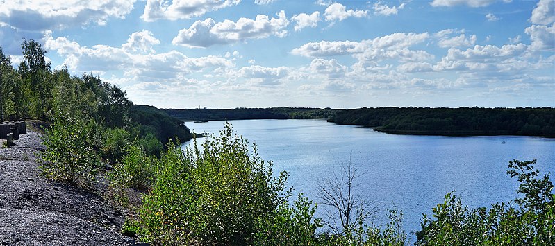
Français : Français : La mare à Goriaux est un lac d'affaissement minier situé près de la fosse Arenberg de la Compagnie des mines d'Anzin dans le bassin minier du Nord-Pas-de-Calais, Raismes et Wallers, Nord, Nord-Pas-de-Calais, France. La mare à Goriaux est inscrite sur la liste du patrimoine mondial par l'Unesco le 30 juin 2012 et y constitue en partie le site no 15. English: La mare à Goriaux is a mining subsidence lake located near the Arenberg pit of the Compagnie des mines d'Anzin in the mining basin of Nord-Pas-de-Calais, Raismes and Wallers, Nord, Nord-Pas-de- Calais, France. The pond at Goriaux was inscribed on the World Heritage list by Unesco on June 30, 2012 and partly constitutes site no.15
|
||||
| Date | |||||
| Source | Own work | ||||
| Author | Pierre André Leclercq | ||||
| Permission (Reusing this file) |
|
.jpg)

.jpg&action=edit§ion=1)
| Camera location | | View this and other nearby images on: OpenStreetMap |
|---|
.jpg¶ms=050.402993_N_0003.438526_E_globe:Earth_type:camera__&language=en)
Licensing[edit]
.jpg&action=edit§ion=2)
- You are free:
- to share – to copy, distribute and transmit the work
- to remix – to adapt the work
- Under the following conditions:
- attribution – You must give appropriate credit, provide a link to the license, and indicate if changes were made. You may do so in any reasonable manner, but not in any way that suggests the licensor endorses you or your use.
- share alike – If you remix, transform, or build upon the material, you must distribute your contributions under the same or compatible license as the original.

|
This image was uploaded as part of Wiki Loves Monuments 2019.
|

|
This image has been assessed under the valued image criteria and is considered the most valued image on Commons within the scope: Mare à Goriaux, view from Terril n° 171, Fosse Arenberg, Wallers. You can see its nomination here. |
.jpg)
File history
Click on a date/time to view the file as it appeared at that time.
| Date/Time | Thumbnail | Dimensions | User | Comment | |
|---|---|---|---|---|---|
| current | 21:33, 17 August 2021 | | 4,699 × 2,088 (2.89 MB) | Pierre André Leclercq (talk | contribs) | correction de l'inclinaison |
| 21:05, 9 September 2019 |  | 4,912 × 2,183 (7.44 MB) | Pierre André Leclercq (talk | contribs) | User created page with UploadWizard |
You cannot overwrite this file.
File usage on Commons
The following 4 pages use this file:
.jpg&oldid=683184608)