File:Université Laval.svg
Jump to navigation
Jump to search

Size of this PNG preview of this SVG file: 781 × 599 pixels. Other resolutions: 313 × 240 pixels | 626 × 480 pixels | 1,001 × 768 pixels | 1,280 × 982 pixels | 2,560 × 1,964 pixels | 1,805 × 1,385 pixels.
Original file (SVG file, nominally 1,805 × 1,385 pixels, file size: 4.76 MB)
Captions
Captions
Add a one-line explanation of what this file represents
Summary[edit]
| Description |
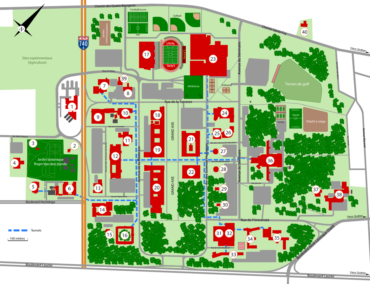
Français : Carte du campus de l'Université Laval. Les notes présentent une visite virtuelle du campus. Les photographies sont localisées le plus précisément possible du lieu où elles ont été prises et sont accompagnées de la date de prise de vue.
1. Centre de foresterie des Laurentides / 2. Maison Omer-Gingras / 3. Maison Couillard / 4. Serres hautes performances / 5. Pavillon Envirotron / 6. Pavillon des services / 7. Pavillon de médecine dentaire / 8. Centrale d'eau refroidie / 9. Pavillon Gene-H.-Kruger / 10. Pavillon Abitibi-Price / 11. Pavillon Charles-Eugène-Marchand / 12. Pavillon Ferdinand Vandry / 13. Héma-Québec / 14. Pavillon Paul-Comtois / 15. La Charmille / 16. Pavillon Agathe-Lacerte / 17. Stade TELUS-Université Laval (intérieur) / 18. Pavillon d'optique-photonique / 19. Pavillon Alexandre-Vachon / 20. Pavillon Adrien-Pouliot / 21. Pavillon Charles-De Koninck / 22. Pavillon Jean-Charles-Bonenfant / 23. PEPS / 24. Pavillon Palasis-Prince / 25. Pavillon J.-A.-DeSève / 26. Pavillon La Laurentienne / 27. Pavillon Jeanne-Lapointe / 28. Pavillon Félix-Antoine-Savard / 29. Maison Eugène-Roberge / 30. Maison Marie-Sirois / 31. Pavillon Alphonse-Desjardins / 32. Pavillon Maurice-Pollack / 33. Pavillon Ernest-Lemieux / 34. Pavillon H.-Biermans-L.-Moraud / 35. Pavillon Alphonse-Marie-Parent / 36. Pavillon Louis-Jacques-Casault / 37. Centre de gestion des matières dangereuses / 38. Pavillon Gérard-Bisaillon / 39. Centre de données massives / 40. Pavillon de l'Est English: Map of Université Laval. Notes are showing a virtual visit of the campus. Pictures are located where they have been taken the more precisely as possible with their date of shooting. |
| Date | |
| Source | Own work |
| Author | Cephas |
Licensing[edit]
I, the copyright holder of this work, hereby publish it under the following license:
This file is licensed under the Creative Commons Attribution-Share Alike 3.0 Unported license.
- You are free:
- to share – to copy, distribute and transmit the work
- to remix – to adapt the work
- Under the following conditions:
- attribution – You must give appropriate credit, provide a link to the license, and indicate if changes were made. You may do so in any reasonable manner, but not in any way that suggests the licensor endorses you or your use.
- share alike – If you remix, transform, or build upon the material, you must distribute your contributions under the same or compatible license as the original.
| Annotations | This image is annotated: View the annotations at Commons |


_01.jpg)
_05.jpg)
_06.jpg)
_08.jpg)


_55-o.apatho-880a-peau.jpg)
_55-o.apatho-93p-uterus.jpg)


File history
Click on a date/time to view the file as it appeared at that time.
| Date/Time | Thumbnail | Dimensions | User | Comment | |
|---|---|---|---|---|---|
| current | 23:04, 16 June 2021 | | 1,805 × 1,385 (4.76 MB) | Cephas (talk | contribs) | switch numbers |
| 22:48, 16 June 2021 |  | 1,805 × 1,385 (4.76 MB) | Cephas (talk | contribs) | deletion of Michael-John-Brophy house | |
| 23:04, 9 March 2021 |  | 1,805 × 1,385 (4.76 MB) | Cephas (talk | contribs) | addition of Data Center no 41 | |
| 22:15, 20 October 2015 |  | 1,805 × 1,385 (4.74 MB) | Judicieux (talk | contribs) | Meilleure lisibilité, rues modifiées. | |
| 23:33, 23 November 2012 |  | 2,256 × 1,731 (3.91 MB) | Cephas (talk | contribs) | Street name | |
| 22:07, 8 November 2012 |  | 2,256 × 1,731 (3.91 MB) | Cephas (talk | contribs) | minor corrections | |
| 23:12, 7 November 2012 |  | 2,256 × 1,731 (3.91 MB) | Cephas (talk | contribs) | User created page with UploadWizard |
You cannot overwrite this file.
File usage on Commons
The following 3 pages use this file:
File usage on other wikis
The following other wikis use this file:
- Usage on ar.wikipedia.org
- Usage on en.wikipedia.org
- Usage on eu.wikipedia.org
- Usage on fr.wikipedia.org
- Usage on hu.wikipedia.org
- Usage on ms.wikipedia.org
- Usage on uz.wikipedia.org
- Usage on www.wikidata.org
- Usage on zh.wikipedia.org