File:Underlying maps (detail from Swisstopo Skiroutenkarte RochersdeNaye LT LK 262 S 1950).tiff
Jump to navigation
Jump to search

Size of this JPG preview of this TIF file: 799 × 259 pixels. Other resolutions: 320 × 104 pixels | 1,104 × 358 pixels.
Original file (1,104 × 358 pixels, file size: 1.16 MB, MIME type: image/tiff)
Captions
Captions
Add a one-line explanation of what this file represents
| Description |
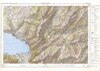
English: Underlying maps: detail from Skiroutenkarte Rochers de Naye, published 1950. |
|||||||||||||||||||||||
| Source |
|
|||||||||||||||||||||||
| Creator | ||||||||||||||||||||||||
| Permission (Reusing this file) |
https://commons.wikimedia.org/wiki/Template:Attribution-Swisstopo | |||||||||||||||||||||||
| Geotemporal data | ||||||||||||||||||||||||
| Scale | 1:50,000 | |||||||||||||||||||||||
| Heading |
 |
|||||||||||||||||||||||
| Bibliographic data | ||||||||||||||||||||||||
| Part of the series | Skiroutenkarten | |||||||||||||||||||||||
| Map sheet | 262 S (crop) | |||||||||||||||||||||||
| Language | French | |||||||||||||||||||||||
| Publisher |
Service topographique fédéral, Wabern-Berne |
|||||||||||||||||||||||
| Archival data | ||||||||||||||||||||||||
| Collection |
Bundesamt für Landestopografie swisstopo, Kartensammlung
|
|||||||||||||||||||||||
| Accession number |
LT LK 262 S 1950 |
|||||||||||||||||||||||

Licensing[edit]
The data made publicly available by swisstopo may be used, distributed and made accessible. Furthermore, they may be enriched and processed and also used commercially. A reference to the source is mandatory. In the case of digital or analogue representations and publications, as well as in the case of dissemination, one of the following source references must be attached in any case:
Terms of use for free geodata and geoservices (OGD) from swisstopo
|
.svg) |
File history
Click on a date/time to view the file as it appeared at that time.
| Date/Time | Thumbnail | Dimensions | User | Comment | |
|---|---|---|---|---|---|
| current | 14:45, 29 September 2023 | 1,104 × 358 (1.16 MB) | Enhancing999 (talk | contribs) | File:Swisstopo Skiroutenkarte RochersdeNaye LT LK 262 S 1950.tif cropped 93 % horizontally, 97 % vertically using CropTool with precise mode. |
You cannot overwrite this file.
File usage on Commons
The following page uses this file: