File:UR Fraternity Lodge map, 1968.tif
Jump to navigation
Jump to search

No higher resolution available.
UR_Fraternity_Lodge_map,_1968.tif (699 × 530 pixels, file size: 366 KB, MIME type: image/tiff)
Captions
Captions
Map of UR Fraternity Lodges from 1968
Summary[edit]
| Description |
English: An aerial photograph from February 26, 1968 cropped to show the fraternity lodges at the University of Richmond |
| Date | |
| Source | https://earthexplorer.usgs.gov/scene/metadata/full/5e83d8e4870f4473/AR1VBYO00020088/ |
| Author | United States Geological Survey |
Licensing[edit]
This image is in the public domain in the United States because it only contains materials that originally came from the United States Geological Survey, an agency of the United States Department of the Interior. For more information, see the official USGS copyright policy.
|
File history
Click on a date/time to view the file as it appeared at that time.
| Date/Time | Thumbnail | Dimensions | User | Comment | |
|---|---|---|---|---|---|
| current | 16:07, 4 January 2022 | 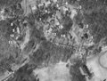 | 699 × 530 (366 KB) | Bdl2001 (talk | contribs) | Uploaded a work by United States Geological Survey from https://earthexplorer.usgs.gov/scene/metadata/full/5e83d8e4870f4473/AR1VBYO00020088/ with UploadWizard |
You cannot overwrite this file.
File usage on Commons
There are no pages that use this file.
File usage on other wikis
The following other wikis use this file:
- Usage on en.wikipedia.org