File:Tumbler Ridge Line.png
Jump to navigation
Jump to search

Size of this preview: 537 × 599 pixels. Other resolutions: 215 × 240 pixels | 430 × 480 pixels | 688 × 768 pixels | 918 × 1,024 pixels | 1,835 × 2,048 pixels | 3,601 × 4,018 pixels.
Original file (3,601 × 4,018 pixels, file size: 3.41 MB, MIME type: image/png)
Captions
Captions
Add a one-line explanation of what this file represents
| Description |
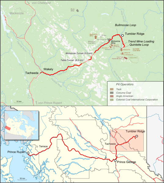
English: Map of Tumbler Ridge Line showing also the served coal pits and future coal projects. Lower map shows complete transporation route to the port of Prince Rupert. |
|||||||||
| Date | ||||||||||
| Source |
Map was created by using
|
|||||||||
| Creator |
|
|||||||||
| Geotemporal data | ||||||||||
| Bounding box |
|
|||||||||
| Georeferencing | ||||||||||
I, the copyright holder of this work, hereby publish it under the following license:
This file is licensed under the Creative Commons Attribution 3.0 Unported license.
- You are free:
- to share – to copy, distribute and transmit the work
- to remix – to adapt the work
- Under the following conditions:
- attribution – You must give appropriate credit, provide a link to the license, and indicate if changes were made. You may do so in any reasonable manner, but not in any way that suggests the licensor endorses you or your use.
| This work is licensed under the Open Database License (summary). |
File history
Click on a date/time to view the file as it appeared at that time.
| Date/Time | Thumbnail | Dimensions | User | Comment | |
|---|---|---|---|---|---|
| current | 04:12, 31 October 2016 | | 3,601 × 4,018 (3.41 MB) | Pechristener (talk | contribs) | korr Beschriftung Wolverine-Tunnel |
| 20:33, 30 October 2016 |  | 3,601 × 4,018 (2.63 MB) | Kopiersperre (talk | contribs) | optipng | |
| 15:51, 30 October 2016 |  | 3,601 × 4,018 (3.41 MB) | Pechristener (talk | contribs) | {{map |Description={{en|1=Map of Tumbler Ridge Line shwoing also the served coal pits and future coal projects. Lower map shows complete transporation way to the port of Prince Rupert.}} |Source=Map was created by using * [http://www.openstreetmap.org... |
You cannot overwrite this file.
File usage on Commons
The following page uses this file:
File usage on other wikis
The following other wikis use this file:
- Usage on de.wikipedia.org
- Usage on www.wikidata.org