File:Tibet state in its region.svg

Original file (SVG file, nominally 450 × 253 pixels, file size: 2.18 MB)
Captions
Captions
Summary[edit]
| DescriptionTibet state in its region.svg |
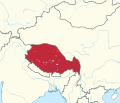
English: Locator map of Tibet (1912–1951), borders about 1945
Deutsch: Locatorkarte des tibetanischen Staates (1912–1951), Grenzen um 1945 |
| Date | |
| Source |
Own work, derivate of File:Bhutan in Asia.svg
Details of baoundary in Kham according to:
Map taken, without reference, from:
Based in turn on:
|
| Author | Don-kun; original: User:TUBS |
Licensing[edit]
- You are free:
- to share – to copy, distribute and transmit the work
- to remix – to adapt the work
- Under the following conditions:
- attribution – You must give appropriate credit, provide a link to the license, and indicate if changes were made. You may do so in any reasonable manner, but not in any way that suggests the licensor endorses you or your use.
File history
Click on a date/time to view the file as it appeared at that time.
| Date/Time | Thumbnail | Dimensions | User | Comment | |
|---|---|---|---|---|---|
| current | 16:38, 15 July 2018 |  | 450 × 253 (2.18 MB) | Don-kun (talk | contribs) | 16:9 |
| 16:16, 15 July 2018 |  | 415 × 355 (2.35 MB) | Don-kun (talk | contribs) | small corrections | |
| 16:46, 14 July 2018 |  | 415 × 355 (2.35 MB) | Don-kun (talk | contribs) | now with tibet | |
| 18:39, 13 July 2018 |  | 415 × 355 (2.32 MB) | Don-kun (talk | contribs) | {{Information |description ={{en|1=Locator map of Tibet (1912–1951), to be}} {{de|1=Locatorkarte des tibetanischen Staates (1912–1951), in Arbeit}} |date =2018-07-13 |source ={{own}}, derivate of File:Bhutan in Asia.svg |author =User:Don-kun; original: User:TUBS }} Category:SVG locator maps of countries of Asia (location map scheme) |
You cannot overwrite this file.
File usage on Commons
The following page uses this file:
File usage on other wikis
The following other wikis use this file:
- Usage on de.wikipedia.org
Metadata
This file contains additional information such as Exif metadata which may have been added by the digital camera, scanner, or software program used to create or digitize it. If the file has been modified from its original state, some details such as the timestamp may not fully reflect those of the original file. The timestamp is only as accurate as the clock in the camera, and it may be completely wrong.
| Width | 450 |
|---|---|
| Height | 253 |