File:Theoretical Search Area MH 370.png
Jump to navigation
Jump to search

Size of this preview: 800 × 490 pixels. Other resolutions: 320 × 196 pixels | 640 × 392 pixels | 1,024 × 627 pixels | 1,280 × 784 pixels | 1,877 × 1,150 pixels.
Original file (1,877 × 1,150 pixels, file size: 1.3 MB, MIME type: image/png)
Captions
Captions
Add a one-line explanation of what this file represents
Summary[edit]
| Description |
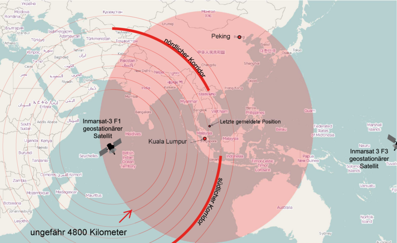
English: Map of the area, where Malaysia Airlines Flight 370 could be found theoretically.
Deutsch: Karte des Gebietes in dem sich der Malaysia-Airlines-Flug 370 theoretisch befinden könnte |
| Date | |
| Source |
Own work Map was created using: |
| Author | OpenStreetMap contributors, Pechristener, Furfur |
| Other versions |
|


Licensing[edit]
This file is licensed under the Creative Commons Attribution-Share Alike 2.0 Generic license.
- You are free:
- to share – to copy, distribute and transmit the work
- to remix – to adapt the work
- Under the following conditions:
- attribution – You must give appropriate credit, provide a link to the license, and indicate if changes were made. You may do so in any reasonable manner, but not in any way that suggests the licensor endorses you or your use.
- share alike – If you remix, transform, or build upon the material, you must distribute your contributions under the same or compatible license as the original.
File history
Click on a date/time to view the file as it appeared at that time.
| Date/Time | Thumbnail | Dimensions | User | Comment | |
|---|---|---|---|---|---|
| current | 21:25, 17 March 2014 | | 1,877 × 1,150 (1.3 MB) | Furfur (talk | contribs) | Satellit über dem Pazifik ergänzt (leider ganz am Rand) |
| 12:36, 17 March 2014 |  | 1,882 × 1,159 (196 KB) | Furfur (talk | contribs) | neue Karte, basierend auf den bisher veröfentlichten Daten / new map based on currently available information | |
| 21:45, 16 March 2014 |  | 1,881 × 1,159 (243 KB) | Furfur (talk | contribs) | Korridor enger gemacht, Satellitenname ergänzt | |
| 19:23, 15 March 2014 |  | 1,879 × 1,160 (242 KB) | Furfur (talk | contribs) | Grafik geändert nach Informationen von http://www.news.com.au/national/uighur-separatists-claim-over-missing-flight-mh370-may-be-reexamined/story-fncynjr2-1226855911080 | |
| 09:19, 15 March 2014 |  | 2,509 × 1,548 (150 KB) | Pechristener (talk | contribs) | Kreis grösser mit einem Radius von 4800 km (gemäss Disk bei Kartenwerkstatt) | |
| 08:17, 15 March 2014 |  | 2,509 × 1,548 (149 KB) | Pechristener (talk | contribs) | {{Information |Description={{en|1=Map of the area, where Malaysia Airlines Flight 370 could be found theoretically.}} {{de|1=Karte des Gebietes in dem sich der [[:de: Malaysia-Airlines-Flug 370| Malaysia-Airlines-F... |
You cannot overwrite this file.
File usage on Commons
The following 6 pages use this file:
File usage on other wikis
The following other wikis use this file:
- Usage on da.wikipedia.org
- Usage on de.wikipedia.org
- Usage on en.wikipedia.org