File:Stadt Ranis, Panorama, 151002, ako.jpg
Jump to navigation
Jump to search

Size of this preview: 800 × 195 pixels. Other resolutions: 320 × 78 pixels | 640 × 156 pixels | 1,024 × 249 pixels | 1,280 × 311 pixels | 2,560 × 623 pixels | 10,000 × 2,433 pixels.
Original file (10,000 × 2,433 pixels, file size: 16.4 MB, MIME type: image/jpeg)
Captions
Captions
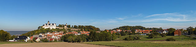
Panoramic view of the city of Ranis (Saale-Orla-Kreis, Thuringia, Germany).
Summary[edit]
| Description |
Deutsch: Panoramaansicht der Stadt Ranis (Saale-Orla-Kreis, Thüringen). Oberhalb der Stadt liegt die Burg Ranis. English: Panoramic view of the city of Ranis (Saale-Orla-Kreis, Thuringia, Germany). Above the town the castle of Ranis can be seen. |
| Date | |
| Source | Own work |
| Author | Ansgar Koreng |
| Permission (Reusing this file) |
CC BY 3.0 (DE) |
| Attribution (required by the license) | Ansgar Koreng / |
| Camera location | | View this and other nearby images on: OpenStreetMap |
|---|
| Camera Model | Canon EOS 6D |
|---|---|
| Shutter speed | 1/320s |
| Aperture | f/8 |
| Film speed (ISO) | 100 |
| Lens | Canon EF 50mm F1.8 II |
| Focal length | 50mm |
| Support | Manfrotto 055XPro3 Tripod with 498RC2 ball head and Nodal Ninja 3 Mk II panoramic head |
| Notes | Stitched from 6 exposures |

|
NOTE: This image is a panorama consisting of multiple frames that were merged or stitched in software. As a result, this image necessarily underwent some form of digital manipulation. These manipulations may include blending, blurring, cloning, and colour and perspective adjustments. As a result of these adjustments, the image content may be slightly different from reality at the points where multiple images were combined. This manipulation is often required due to lens, perspective, and parallax distortions.
|
This image has been assessed using the Quality image guidelines and is considered a Quality image.
|
Licensing[edit]
Ansgar Koreng, the copyright holder of this work, hereby publishes it under the following license:
This file is licensed under the Creative Commons Attribution 3.0 Germany license.
Attribution: Ansgar Koreng / CC BY 3.0 (DE)
- You are free:
- to share – to copy, distribute and transmit the work
- to remix – to adapt the work
- Under the following conditions:
- attribution – You must give appropriate credit, provide a link to the license, and indicate if changes were made. You may do so in any reasonable manner, but not in any way that suggests the licensor endorses you or your use.

Modifications[edit]
|
|
Please do not upload a modified image here without consultation with the Author. The author would like to make corrections only at his own source. This ensures that the changes are preserved. |

File history
Click on a date/time to view the file as it appeared at that time.
| Date/Time | Thumbnail | Dimensions | User | Comment | |
|---|---|---|---|---|---|
| current | 17:58, 6 October 2015 | 10,000 × 2,433 (16.4 MB) | Code (talk | contribs) | =={{int:filedesc}}== {{Information |description={{de|1=Panoramaansicht der Stadt Ranis (Saale-Orla-Kreis, Thüringen). Oberhalb der Stadt liegt die Burg Ranis.}}{{en|1=Panoramic view of the city of Ranis (Saale-Orla-Kreis, Thuringia, Germany). Above th... |
You cannot overwrite this file.
File usage on Commons
The following 3 pages use this file:
File usage on other wikis
The following other wikis use this file: