File:Spandauer Forst protected areas as of 2017 with DOP20RGB-2019.tif
Jump to navigation
Jump to search

Size of this PNG preview of this TIF file: 800 × 510 pixels. Other resolutions: 320 × 204 pixels | 640 × 408 pixels | 1,024 × 653 pixels | 1,280 × 816 pixels | 2,560 × 1,632 pixels | 9,384 × 5,981 pixels.
Original file (9,384 × 5,981 pixels, file size: 214.1 MB, MIME type: image/tiff)
Captions
Captions
Add a one-line explanation of what this file represents
Summary
[edit]| Description |
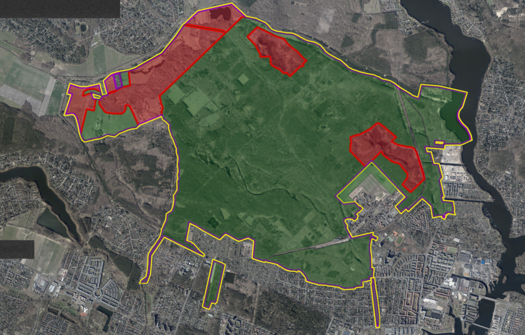
Deutsch: Schutzgebiete im Spandauer Forst mit dem Luftbild aus dem April 2019 im Hintergrund.
Rand der Naturschutzgebiete Fläche des Landschaftsschutzgebiets Rand des FFH-Gebiets Rand des Vogelschutzgebiets |
| Date | |
| Source |
Work based on: Geoportal Berlin / Schutzgebiete im INSPIRE-Datenmodell (Schutzgebiete nach Naturschutzrecht) as of 15.01.2019 Background: Geoportal Berlin / Digitale farbige Orthophotos 2019 (DOP20RGB) |
| Author |
Edited by: Leonhard Lenz Original data: Geoportal Berlin |
Licensing
[edit]
|
This file is licensed under the terms of the Data licence Germany – attribution – version 2.0 |
|
You are free:
Under the following conditions:
|
File history
Click on a date/time to view the file as it appeared at that time.
| Date/Time | Thumbnail | Dimensions | User | Comment | |
|---|---|---|---|---|---|
| current | 16:00, 19 June 2020 |  | 9,384 × 5,981 (214.1 MB) | GPSLeo (talk | contribs) | Uploaded a work by Edited by: Leonhard Lenz Original data: Geoportal Berlin from Work based on: Geoportal Berlin / Schutzgebiete im INSPIRE-Datenmodell (Schutzgebiete nach Naturschutzrecht) as of 15.01.2019 Background: Geoportal Berlin / Digitale farbige Orthophotos 2019 (DOP20RGB) with UploadWizard |
You cannot overwrite this file.
File usage on Commons
The following 2 pages use this file:
File usage on other wikis
The following other wikis use this file:
- Usage on de.wikipedia.org