File:Schlesien1890 Brockhaus14thed.tif
Jump to navigation
Jump to search

Size of this JPG preview of this TIF file: 770 × 600 pixels. Other resolutions: 308 × 240 pixels | 616 × 480 pixels | 986 × 768 pixels | 1,280 × 997 pixels | 2,560 × 1,994 pixels | 4,746 × 3,697 pixels.
Original file (4,746 × 3,697 pixels, file size: 50.23 MB, MIME type: image/tiff)
Captions
Captions
Add a one-line explanation of what this file represents
Summary
[edit]| Description |
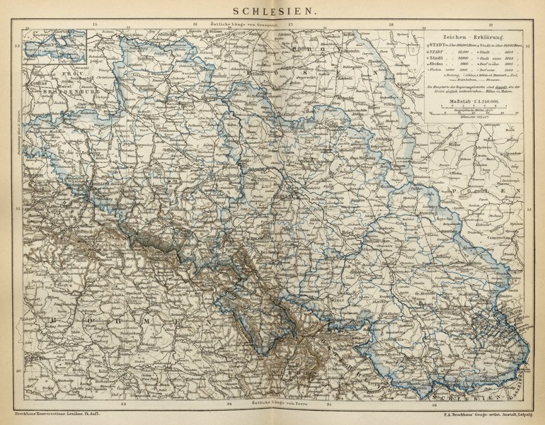
English: Map of Silesia as published in en:Brockhaus Enzyklopädie 14th edition
While the map marks the longitude by lines indicating east of Ferro, with numbers on the bottom, it indicates longitude east of Greenwhich by numbers on the upper edge Deutsch: Karte von Schlesien aus der de:Brockhaus Enzyklopädie, 14. Auflage 1892
Die Karte markiert mit vertikalen Linien die östliche Länge von Ferro, mit den Zahlen am unteren Rand, zeigt aber auch die östliche Länge von Greenwhich am oberen Rand. |
|||||
| Date | ||||||
| Source | en:Brockhaus Enzyklopädie 14th edition | |||||
| Author | F.A. Brockhaus Geogr.-artist. Anstalt, Leipzig | |||||
| Permission (Reusing this file) |
|
File history
Click on a date/time to view the file as it appeared at that time.
| Date/Time | Thumbnail | Dimensions | User | Comment | |
|---|---|---|---|---|---|
| current | 23:59, 21 April 2016 |  | 4,746 × 3,697 (50.23 MB) | L.Willms (talk | contribs) | {{Information |Description ={{en|1=Map of Silesia as published in en:Brockhaus Enzyklopädie 14th edition}} {{de|1=Karte von Schlesien aus dem de:Brockhaus Enzyklopädie, 14. Auflage 1892}} |Source =en:Brockhaus Enzyklopädie... |
You cannot overwrite this file.
File usage on Commons
There are no pages that use this file.