File:River Rouge Dearborn.jpg
Jump to navigation
Jump to search

Size of this preview: 800 × 561 pixels. Other resolutions: 320 × 224 pixels | 640 × 448 pixels | 1,024 × 717 pixels | 1,280 × 897 pixels | 1,500 × 1,051 pixels.
Original file (1,500 × 1,051 pixels, file size: 506 KB, MIME type: image/jpeg)
Captions
Captions
Add a one-line explanation of what this file represents
| Description |
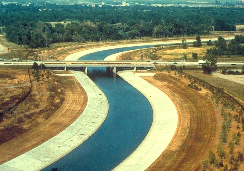
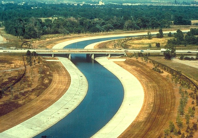
English: River Rouge in Dearborn, Michigan, USA. The U.S. Army Corps of Engineers has channelized the river as a flood control project. The view in the picture appears to be looking west across the Southfield Freeway, M-39. |
|||
| Date | not specified or unknown | |||
| Source |
U.S. Army Corps of Engineers Digital Visual Library Image page Image description page Digital Visual Library home page |
|||
| Author | U.S. Army Corps of Engineers, photographer not specified or unknown | |||
| Permission (Reusing this file) |
|
|||
| Location | Dearborn, Michigan, USA |
| Camera location | | View this and other nearby images on: OpenStreetMap |
|---|
File history
Click on a date/time to view the file as it appeared at that time.
| Date/Time | Thumbnail | Dimensions | User | Comment | |
|---|---|---|---|---|---|
| current | 03:58, 29 March 2007 | | 1,500 × 1,051 (506 KB) | DanMS (talk | contribs) | {{Information | Description = {{en|River Rouge in Dearborn, Michigan, USA. The U.S. Army Corps of Engineers has channelized the river as a flood control project. The view in the picture appears to be looking west across the Smithfield Freeway, Michigan |
You cannot overwrite this file.
File usage on Commons
The following page uses this file:
File usage on other wikis
The following other wikis use this file:
- Usage on de.wikipedia.org
- Usage on en.wikipedia.org
- River Rouge (Michigan)
- M-39 (Michigan highway)
- Michigan State Trunkline Highway System
- Portal:Michigan highways
- Portal:Michigan highways/Pictures
- Portal:Michigan highways/Selected picture/September 2011
- Portal:Michigan highways/Did you know
- Portal:Michigan highways/Did you know/August 2012
- Portal:Michigan highways/Did you know/April 2014
- Portal:Michigan highways/Did you know/May 2016
- Portal:Michigan highways/Did you know/January 2018
- Portal:Michigan highways/Did you know/April 2020
- Usage on fr.wikipedia.org
- Usage on ja.wikipedia.org
- Usage on mk.wikipedia.org
Metadata
Categories:
- Dearborn, Michigan
- M-39 (Michigan highway)
- River Rouge
- Bridges over rivers in Michigan
- Road bridges in Michigan
- Girder bridges in Michigan
- 1960s bridges in Michigan
- Built in Michigan in 1963
- Bridges in the United States completed in 1963
- Steel bridges in the United States
- 0.1-kilometer bridges in the United States