File:Red Banke. LOC gm71002224.tif
Jump to navigation
Jump to search

Size of this JPG preview of this TIF file: 800 × 555 pixels. Other resolutions: 320 × 222 pixels | 640 × 444 pixels | 1,024 × 711 pixels | 1,280 × 889 pixels | 2,560 × 1,777 pixels | 4,102 × 2,848 pixels.
Original file (4,102 × 2,848 pixels, file size: 33.42 MB, MIME type: image/tiff)
Captions
Captions
Add a one-line explanation of what this file represents
Summary
[edit]| Description |
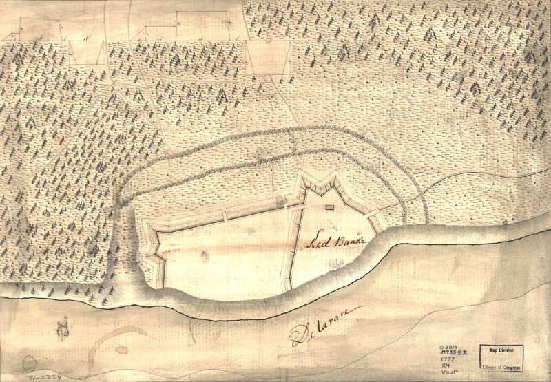
English: Scale not given. Manuscript, pen-and-ink and watercolor. Has watermarks. Oriented with north toward the lower right. Relief shown by hachures. Shows fortifications of Fort Mercer, N.J. currently located in Red Bank Battlefield in the borough of National Park, Gloucester County. Includes profile. LC Maps of North America, 1750-1789, 1275 Available also through the Library of Congress Web site as a raster image. Vault AACR2: 440 |
||
| Title | Red Banke. | ||
| Shelf ID | G3814.N2:2F6S3 1777 .R4 | ||
| Date | |||
| Source | https://www.loc.gov/item/gm71002224/ | ||
| Author | Unknown author | ||
| Permission (Reusing this file) |
|
||
| Other versions |
|
||
| Location | New Jersey · United States · National Park · Fort Mercer (National Park) · Fort Mercer | ||
| Part of | Military Battles And Campaigns · American Memory · Catalog · Geography And Map Division · American Revolution And Its Era: Maps And Charts Of North America And The West Indies, 1750-1789 | ||
| Subject | Maps, Manuscript · New Jersey · Fort Mercer (National Park, N.J.) · United States · Early Works To 1800 · Fort Mercer (National Park) |


Licensing
[edit]|
This is a faithful photographic reproduction of a two-dimensional, public domain work of art. The work of art itself is in the public domain for the following reason:
The official position taken by the Wikimedia Foundation is that "faithful reproductions of two-dimensional public domain works of art are public domain".
This photographic reproduction is therefore also considered to be in the public domain in the United States. In other jurisdictions, re-use of this content may be restricted; see Reuse of PD-Art photographs for details. | ||||
File history
Click on a date/time to view the file as it appeared at that time.
| Date/Time | Thumbnail | Dimensions | User | Comment | |
|---|---|---|---|---|---|
| current | 11:45, 9 October 2023 |  | 4,102 × 2,848 (33.42 MB) | Zeete (talk | contribs) | Cropped 6 % horizontally, 9 % vertically using CropTool with precise mode. |
| 23:55, 29 December 2020 |  | 4,349 × 3,113 (38.76 MB) | Gwillhickers (talk | contribs) | Same file, rendered for better brightness and sharpness | |
| 04:38, 1 June 2018 |  | 4,349 × 3,113 (38.73 MB) | Fæ (talk | contribs) | LOC Maps https://www.loc.gov/item/gm71002224/ #1299 |
You cannot overwrite this file.
File usage on Commons
The following 4 pages use this file:
File usage on other wikis
The following other wikis use this file:
- Usage on arz.wikipedia.org
- Usage on en.wikipedia.org
- Usage on www.wikidata.org