File:Railways in High Tatras schematic en.svg
Jump to navigation
Jump to search

Size of this PNG preview of this SVG file: 800 × 400 pixels. Other resolutions: 320 × 160 pixels | 640 × 320 pixels | 1,024 × 512 pixels | 1,280 × 640 pixels | 2,560 × 1,280 pixels | 1,100 × 550 pixels.
Original file (SVG file, nominally 1,100 × 550 pixels, file size: 220 KB)
Captions
Captions
Add a one-line explanation of what this file represents
Summary[edit]
| Description |
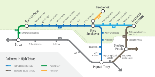
English: Railway network in High Tatras
Deutsch: Eisenbahnnetz in der Hohen Tatra
Polski: Sieć kolejowa w Tatrach Wysokich |
||||||
| Date | |||||||
| Source | Own work | ||||||
| Author | Krumpi | ||||||
| Other versions |
|
||||||
| SVG development | This map was created with an unknown SVG tool.
|


Licensing[edit]
I, the copyright holder of this work, hereby publish it under the following license:
This file is licensed under the Creative Commons Attribution-Share Alike 4.0 International license.
- You are free:
- to share – to copy, distribute and transmit the work
- to remix – to adapt the work
- Under the following conditions:
- attribution – You must give appropriate credit, provide a link to the license, and indicate if changes were made. You may do so in any reasonable manner, but not in any way that suggests the licensor endorses you or your use.
- share alike – If you remix, transform, or build upon the material, you must distribute your contributions under the same or compatible license as the original.
File history
Click on a date/time to view the file as it appeared at that time.
| Date/Time | Thumbnail | Dimensions | User | Comment | |
|---|---|---|---|---|---|
| current | 21:37, 18 November 2019 | | 1,100 × 550 (220 KB) | Krumpi (talk | contribs) | minor corrections, valid svg code |
| 21:57, 17 November 2019 |  | 1,100 × 550 (222 KB) | Krumpi (talk | contribs) | User created page with UploadWizard |
You cannot overwrite this file.
File usage on Commons
The following 12 pages use this file:
- User:Chumwa/OgreBot/Potential transport maps/2019 November 11-20
- User:Chumwa/OgreBot/Public transport information/2019 November 11-20
- User:Chumwa/OgreBot/Transport Maps/2019 November 11-20
- User:Krumpi
- User:Krumpi/gallery
- File:Railways in High Tatras map en.svg
- File:Railways in High Tatras map sk.svg
- File:Railways in High Tatras schematic sk.svg
- File:TEŽ+OŽ scheme.svg
- File:Tatra local railways.png
- Category:Ozubnicová železnica Štrba - Štrbské Pleso
- Category:Tatra Electric Railways
File usage on other wikis
The following other wikis use this file:
- Usage on de.wikipedia.org
- Usage on en.wikipedia.org
- Usage on en.wikivoyage.org
- Usage on fr.wikipedia.org
- Usage on he.wikipedia.org
- Usage on hu.wikipedia.org
- Usage on it.wikipedia.org
- Usage on nl.wikipedia.org
- Usage on pl.wikipedia.org
- Usage on ru.wikipedia.org
- Usage on sk.wikipedia.org
- Usage on uk.wikipedia.org
- Usage on www.wikidata.org