File:Rüzgar erozyonu risk dağılımı.jpg
Jump to navigation
Jump to search

Size of this preview: 800 × 518 pixels. Other resolutions: 320 × 207 pixels | 640 × 414 pixels | 1,024 × 663 pixels | 1,280 × 828 pixels | 3,000 × 1,941 pixels.
Original file (3,000 × 1,941 pixels, file size: 2.78 MB, MIME type: image/jpeg)
Captions
Captions
Add a one-line explanation of what this file represents
| Description |
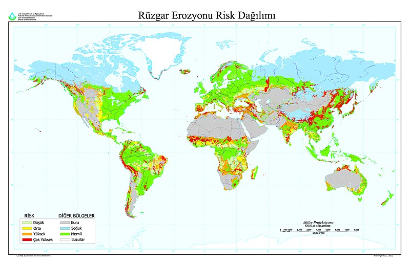
Türkçe: Dünyada rüzgar erozyonu risk dağılımını gösteren harita. |
| Date | Orijinal harita: 2002. Bu versiyon: 15 Aralık 2007 |
| Source |
Transferred from tr.wikipedia to Commons. original: Türkçe: http://soils.usda.gov/use/worldsoils/mapindex/eroswind.html - ABD Tarım Bak.'na ait Ulusal Tarım Kütüphanesi çalışması. |
| Author | Ulusal Tarım Kütüphanesi (ABD) |
| Other versions |
versions Türkçe: Haritanın orijinal sürümü 6800x4400 boyutlarında ve İngilizce olarak, yazılmış olan kaynakta yer alır |
This file is a work of a U.S. Army soldier or employee, taken or made as part of that person's official duties. As a work of the U.S. federal government, it is in the public domain in the United States.
|
 |
File history
Click on a date/time to view the file as it appeared at that time.
| Date/Time | Thumbnail | Dimensions | User | Comment | |
|---|---|---|---|---|---|
| current | 09:25, 16 December 2007 | | 3,000 × 1,941 (2.78 MB) | Gökhan (talk | contribs) | {{Bilgi |açıklama= Dünyada rüzgar erozyonu risk dağılımını gösteren harita. |kaynak= http://soils.usda.gov/use/worldsoils/mapindex/eroswind.html - ABD Tarım Bak.'na ait Ulusal Tarım Kütüphanesi çalışması. |tarih= Orijinal harita: 2002. |
You cannot overwrite this file.
File usage on Commons
There are no pages that use this file.