File:Queens, Vol. 2, Double Page Plate No. 3; Part of Long Island City Ward One (Part of Old Ward 2, 3 and 4). (Map bounded by Washington Ave., Webster Ave., Freeman Ave., Rapelje Ave., Beebe Ave., NYPL1693949.tiff
Jump to navigation
Jump to search

Size of this JPG preview of this TIF file: 800 × 593 pixels. Other resolutions: 320 × 237 pixels | 640 × 474 pixels | 1,024 × 759 pixels | 1,280 × 948 pixels | 2,560 × 1,897 pixels | 6,888 × 5,104 pixels.
Original file (6,888 × 5,104 pixels, file size: 100.59 MB, MIME type: image/tiff)
Captions
Captions
Add a one-line explanation of what this file represents
Summary
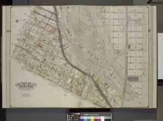
[edit]| Description | Queens, Vol. 2, Double Page Plate No. 3; Part of Long Island City Ward One (Part of Old Ward 2, 3 and 4). [Map bounded by Washington Ave., Webster Ave., Freeman Ave., Rapelje Ave., Beebe Ave., Payntar Ave., Wilbur Ave., Hunter Ave., Jackson Ave., Thomson Ave., Nott Ave. Harris Ave., Skillman Ave. Queens Boulevard, Foster Ave.; Including Prospect st., Radde St., Academy St., Lockwood St., Lathrop St., Briell St., Bartow St., Blackwell St., Pomeroy St., North Jane St., South Jane St., Henry St., Barn St., Orchard St., Queens Pl., Dutch Kills Pl., Creek St., Van Pelt St., Hulst St., Buckley St., Honeywell St., Moore St., Rawson St., Hill St., Vandam St., School St., Mount St., Manley St., Orton St.]; Atlases of New York city. / Atlas of the borough of Queens, city of New York : based upon official plans and maps on file in the various city offices; supplemented by careful field measurements and personal observations / by and under the supervision of Hugo Ullitz. / Long Island City. | |||||||||||||||||||||||
| Catalogue call number | Map Div.+++ (Queens, New York. 1912-1913) (Hyde, E.B., Map Co., Inc. Atlas of the borough of Queens) | |||||||||||||||||||||||
| Item/Page/Plate | 3 | |||||||||||||||||||||||
| Date | between 1907 and 1908 | |||||||||||||||||||||||
| Source |
http://digitalgallery.nypl.org/nypldigital/dgkeysearchdetail.cfm?imageID=1693949
|
|||||||||||||||||||||||
| Author | ||||||||||||||||||||||||
| Permission (Reusing this file) |
From The Lionel Pincus and Princess Firyal Map Division. http://maps.nypl.org
|
|||||||||||||||||||||||
| Location | Stephen A. Schwarzman Building / The Lionel Pincus and Princess Firyal Map Division | |||||||||||||||||||||||
| Digital item published | 3-4-2009; updated 3-25-2011 | |||||||||||||||||||||||
| Digital ID | 1693949 | |||||||||||||||||||||||

The making of this file was supported by Wikimedia UK.
To see other files made with the support of Wikimedia UK, please see the category Supported by Wikimedia UK.
|
File history
Click on a date/time to view the file as it appeared at that time.
| Date/Time | Thumbnail | Dimensions | User | Comment | |
|---|---|---|---|---|---|
| current | 11:52, 8 May 2014 |  | 6,888 × 5,104 (100.59 MB) | Fæ (talk | contribs) | GWToolset: Creating mediafile for Fæ. Tranche 4 -4989 restart @08:55 BST, 7 May 2014 |
You cannot overwrite this file.
File usage on Commons
There are no pages that use this file.