File:QZ8501 flight path.png
Jump to navigation
Jump to search
Size of this preview: 692 × 600 pixels. Other resolutions: 277 × 240 pixels | 554 × 480 pixels | 886 × 768 pixels | 1,181 × 1,024 pixels | 2,362 × 2,048 pixels | 3,134 × 2,717 pixels.
Original file (3,134 × 2,717 pixels, file size: 1.05 MB, MIME type: image/png)
Captions
Captions
Add a one-line explanation of what this file represents
Summary[edit]
| Description |
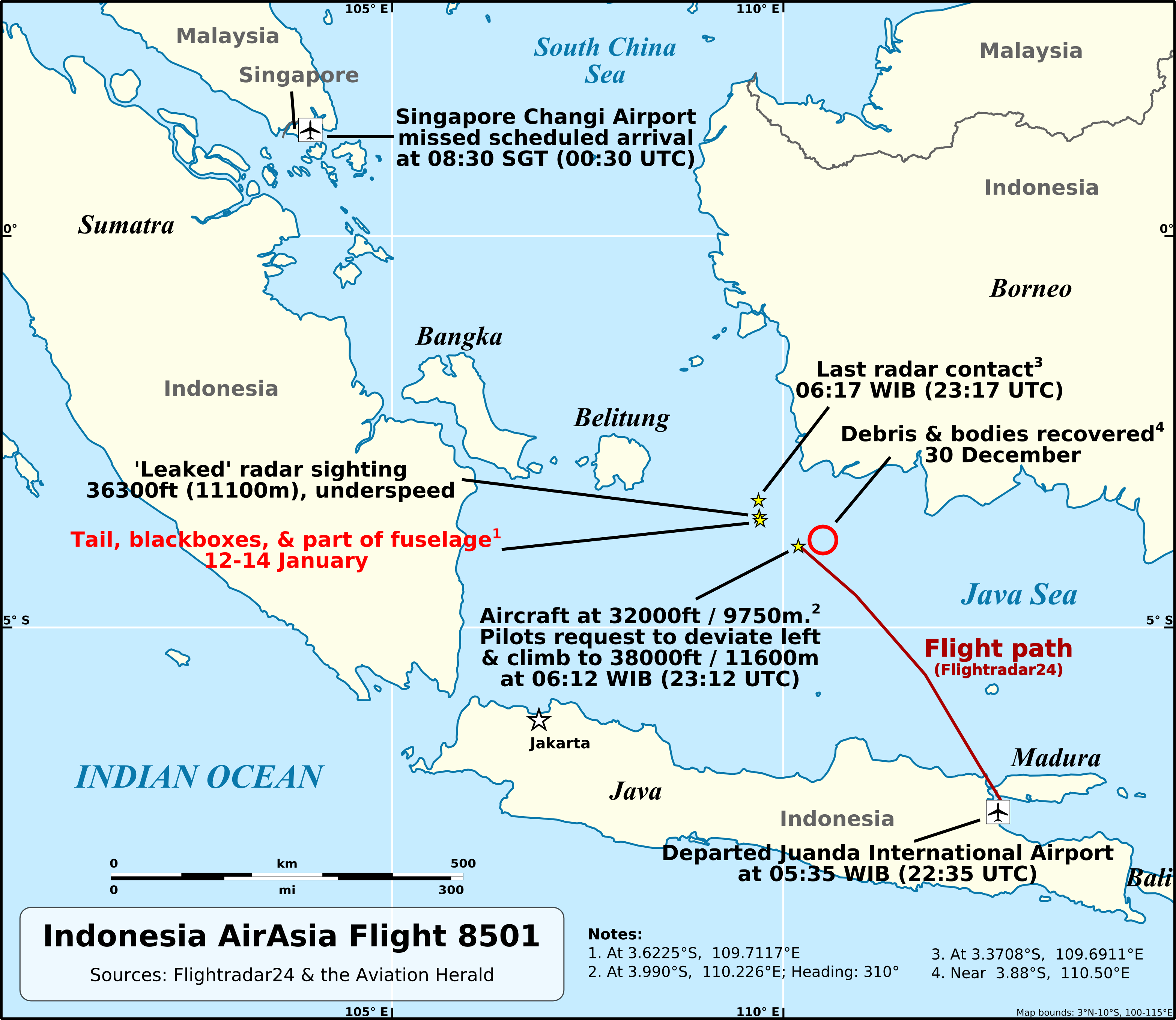
English: Flight path of Indonesia AirAsia Flight 8501. |
|||
| Date | ||||
| Source |
Own work Background created with Natural Earth data (public domain). |
|||
| Author | AHeneen | |||
| Permission (Reusing this file) |
I, the copyright holder of this work, hereby publish it under the following license: This file is licensed under the Creative Commons Attribution 4.0 International license.
|
|||
| Other versions |
|


File history
Click on a date/time to view the file as it appeared at that time.
| Date/Time | Thumbnail | Dimensions | User | Comment | |
|---|---|---|---|---|---|
| current | 19:36, 18 January 2015 | | 3,134 × 2,717 (1.05 MB) | AHeneen (talk | contribs) | Updated with location of fuselage/blackboxes/tail; change font (needed to be changed on SVG file as previous font, Arial, is not supported by Wikimedia); removed search area, because as search has unfolded, that area is not very relevant (reduce mapclu... |
| 03:02, 3 January 2015 |  | 3,134 × 2,717 (1.1 MB) | AHeneen (talk | contribs) | correct altitude of leaked radar sighting | |
| 23:48, 30 December 2014 |  | 3,134 × 2,717 (1.1 MB) | AHeneen (talk | contribs) | Add debris sightings & more | |
| 21:30, 29 December 2014 |  | 3,134 × 2,717 (937 KB) | AHeneen (talk | contribs) | Add search area, correct time of loss, change area where contact was lost | |
| 21:22, 28 December 2014 |  | 3,134 × 2,717 (898 KB) | AHeneen (talk | contribs) | add scale, lat/long, fix title, & other improvements | |
| 07:47, 28 December 2014 |  | 3,134 × 2,717 (800 KB) | AHeneen (talk | contribs) | User created page with UploadWizard |
You cannot overwrite this file.
File usage on Commons
The following 11 pages use this file:
- December 2014
- User:Chumwa/OgreBot/Transport Maps/2014 December 21-31
- Commons:WikiProject Aviation/recent uploads/2014 December 28
- File:Indonesia AirAsia Flight 8501 flight plan.svg
- File:QZ8501 Flugroute.png
- File:QZ8501 flight path ID.png
- File:QZ8501 flight path blank.png
- File:QZ8501 flight path blank svg.svg
- File:QZ8501 flight path french.png
- File:QZ8501 flight path svg multilingual.svg
- Template:Other versions/QZ8501 flight path
File usage on other wikis
The following other wikis use this file:
- Usage on bg.wikipedia.org
- Usage on bn.wikipedia.org
- Usage on da.wikipedia.org
- Usage on de.wikipedia.org
- Usage on de.wikinews.org
- Usage on en.wikipedia.org
- Usage on fi.wikipedia.org
- Usage on fo.wikipedia.org
- Usage on fr.wikipedia.org
- Usage on he.wikipedia.org
- Usage on hi.wikipedia.org
- Usage on hu.wikipedia.org
- Usage on id.wikipedia.org
- Usage on mr.wikipedia.org
- Usage on ms.wikipedia.org
- Usage on ru.wikipedia.org
- Usage on ru.wikinews.org
- Usage on si.wikipedia.org
- Usage on sr.wikinews.org
- Usage on th.wikipedia.org
- Usage on uk.wikipedia.org
- Usage on zh.wikipedia.org