File:Préfectures de France 2016.svg
Jump to navigation
Jump to search

Size of this PNG preview of this SVG file: 588 × 550 pixels. Other resolutions: 257 × 240 pixels | 513 × 480 pixels | 821 × 768 pixels | 1,095 × 1,024 pixels | 2,190 × 2,048 pixels.
Original file (SVG file, nominally 588 × 550 pixels, file size: 436 KB)
Captions
Captions
Add a one-line explanation of what this file represents
Summary[edit]
| Description |
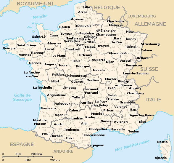
Français : Localisation des préfectures de France, avec le nouveau découpage des régions de 2016. |
| Date | |
| Source | File:Préfectures de France.svg |
| Author | Bayo, derivative work: Skimel (new region boundaries) |
| Other versions |
This file was derived from: Préfectures de France.svg:  |
Licensing[edit]
This work is based on a work in the public domain. It has been digitally enhanced and/or modified. This derivative work has been (or is hereby) released into the public domain by its author, Skimel. This applies worldwide.
In some countries this may not be legally possible; if so: |
File history
Click on a date/time to view the file as it appeared at that time.
| Date/Time | Thumbnail | Dimensions | User | Comment | |
|---|---|---|---|---|---|
| current | 19:21, 25 January 2017 | | 588 × 550 (436 KB) | Flappiefh (talk | contribs) | Fixed XML code (simplified doc, and removed unuseful Normandy label path which was bugged). |
| 11:54, 20 January 2017 |  | 588 × 550 (801 KB) | Skimel (talk | contribs) | Mise à jour limite des Hauts-de-France | |
| 15:46, 18 January 2017 |  | 588 × 550 (444 KB) | Skimel (talk | contribs) | User created page with UploadWizard |
You cannot overwrite this file.
File usage on Commons
The following 3 pages use this file:
File usage on other wikis
The following other wikis use this file:
- Usage on als.wikipedia.org
- Usage on de.wikipedia.org
- Usage on en.wikipedia.org
- Usage on fr.wikipedia.org
- Usage on ja.wikipedia.org