File:Pine Island cracked ESA253149.tiff
Jump to navigation
Jump to search

Size of this JPG preview of this TIF file: 800 × 514 pixels. Other resolutions: 320 × 206 pixels | 640 × 412 pixels | 1,024 × 658 pixels | 1,280 × 823 pixels | 2,560 × 1,646 pixels | 4,042 × 2,599 pixels.
Original file (4,042 × 2,599 pixels, file size: 30.02 MB, MIME type: image/tiff)
Captions
Captions
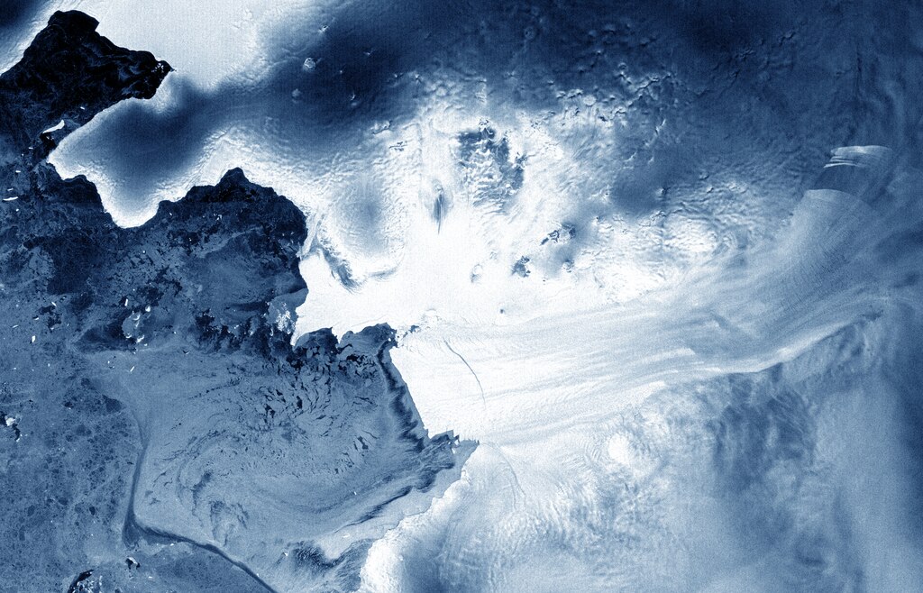
A crack on the Pine Island Glacier Ice Shelf, Antarctica in 2012
Summary
[edit]| Description |
English: This Envisat image shows the Pine Island Glacier in West Antarctica and reveals a crack in the glacier’s tongue about 25 km long. The image was acquired by Envisat’s radar on 6 April 2012, just two days before contact with the satellite was lost.
Over its ten-year lifetime, Envisat’s radar imagery was constantly used to monitor ice in the Antarctic. Satellite radars are particularly useful over polar regions because they can see through clouds and darkness. |
| Date | |
| Source | http://www.esa.int/spaceinimages/Images/2012/06/Pine_Island_cracked |
| Author | European Space Agency |
| Permission (Reusing this file) |
ESA,CC BY-SA 3.0 IGO |
| Other versions |
|
| Title | Pine Island cracked |
| Keywords | Ice and snow; Glaciers |
| Set | Earth observation image of the week |
| Mission | Envisat |
| Activity | Observing the Earth |

Licensing
[edit]This file is licensed under the Creative Commons Attribution-ShareAlike 3.0 IGO license.
Attribution: ESA
- You are free:
- to share – to copy, distribute and transmit the work
- to remix – to adapt the work
- Under the following conditions:
- attribution – You must give appropriate credit, provide a link to the license, and indicate if changes were made. You may do so in any reasonable manner, but not in any way that suggests the licensor endorses you or your use.
- share alike – If you remix, transform, or build upon the material, you must distribute your contributions under the same or compatible license as the original.
File history
Click on a date/time to view the file as it appeared at that time.
| Date/Time | Thumbnail | Dimensions | User | Comment | |
|---|---|---|---|---|---|
| current | 11:42, 24 May 2017 |  | 4,042 × 2,599 (30.02 MB) | Fæ (talk | contribs) | European Space Agency, Id 253149, http://www.esa.int/spaceinimages/Images/2012/06/Pine_Island_cracked, User:Fæ/Project_list/ESA |
You cannot overwrite this file.
File usage on Commons
There are no pages that use this file.