File:Penong-Kevin-Thevenard (Eyre Peninsula) rail maps 1919-2019.tif
Jump to navigation
Jump to search

Size of this PNG preview of this TIF file: 341 × 599 pixels. Other resolutions: 136 × 240 pixels | 273 × 480 pixels | 437 × 768 pixels | 583 × 1,024 pixels | 1,284 × 2,255 pixels.
Original file (1,284 × 2,255 pixels, file size: 11.05 MB, MIME type: image/tiff)
Captions
Captions
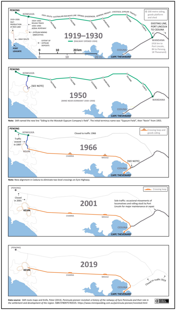
Five maps of Penong-Kevin-Thevenard (Eyre Peninsula) rail routes, 1919-2019
Summary[edit]
| Description |
English: Five maps showing the evolution of the Penong-Kevin-Thevenard rail routes on Eyre Peninsula, South Australia,1919-2019 |
| Date | |
| Source | Own work |
| Author | SCHolar44 |
| Camera location | | View this and other nearby images on: OpenStreetMap |
|---|
Licensing[edit]
I, the copyright holder of this work, hereby publish it under the following license:
| This file is made available under the Creative Commons CC0 1.0 Universal Public Domain Dedication. | |
| The person who associated a work with this deed has dedicated the work to the public domain by waiving all of their rights to the work worldwide under copyright law, including all related and neighboring rights, to the extent allowed by law. You can copy, modify, distribute and perform the work, even for commercial purposes, all without asking permission.
|
File history
Click on a date/time to view the file as it appeared at that time.
| Date/Time | Thumbnail | Dimensions | User | Comment | |
|---|---|---|---|---|---|
| current | 05:10, 22 June 2023 |  | 1,284 × 2,255 (11.05 MB) | SCHolar44 (talk | contribs) | A little more detail |
| 00:23, 17 June 2023 |  | 1,284 × 2,255 (11.05 MB) | SCHolar44 (talk | contribs) | Miscellaneous improvements | |
| 05:56, 11 October 2020 |  | 1,320 × 2,277 (11.47 MB) | SCHolar44 (talk | contribs) | Uploaded own work with UploadWizard |
You cannot overwrite this file.
File usage on Commons
The following 6 pages use this file:
- User:Chumwa/OgreBot/Public transport information/2020 October 11-20
- User:Chumwa/OgreBot/Public transport information/2023 June 11-20
- User:Chumwa/OgreBot/Public transport information/2023 June 21-30
- User:Chumwa/OgreBot/Transport Maps/2020 October 11-20
- User:Chumwa/OgreBot/Transport Maps/2023 June 11-20
- User:Chumwa/OgreBot/Transport Maps/2023 June 21-30