File:OttomanCessiontoBulgaria1915.svg
Jump to navigation
Jump to search

Size of this PNG preview of this SVG file: 537 × 599 pixels. Other resolutions: 215 × 240 pixels | 430 × 480 pixels | 688 × 768 pixels | 917 × 1,024 pixels | 1,835 × 2,048 pixels | 1,120 × 1,250 pixels.
Original file (SVG file, nominally 1,120 × 1,250 pixels, file size: 2.75 MB)
Captions
Captions
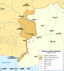
Map of Ottoman cession to Bulgaria in 1915
Summary[edit]
| Description |
English: Map of Ottoman cession to Bulgaria in 6 September 1915, following the convention of Sofia, during WW1. |
| Date | |
| Source | Own work, based on Map of Еastern Thrace borders Bulgaria Ottoman empire 1912 1919-bg.svg |
| Author | Ikonact |
| Other versions |
|
| SVG development |

Licensing[edit]
I, the copyright holder of this work, hereby publish it under the following license:
This file is licensed under the Creative Commons Attribution-Share Alike 4.0 International license.
- You are free:
- to share – to copy, distribute and transmit the work
- to remix – to adapt the work
- Under the following conditions:
- attribution – You must give appropriate credit, provide a link to the license, and indicate if changes were made. You may do so in any reasonable manner, but not in any way that suggests the licensor endorses you or your use.
- share alike – If you remix, transform, or build upon the material, you must distribute your contributions under the same or compatible license as the original.
File history
Click on a date/time to view the file as it appeared at that time.
| Date/Time | Thumbnail | Dimensions | User | Comment | |
|---|---|---|---|---|---|
| current | 22:09, 9 January 2024 | | 1,120 × 1,250 (2.75 MB) | Ikonact (talk | contribs) | correction of border near Edirne |
| 21:42, 9 January 2024 |  | 1,120 × 1,250 (2.75 MB) | Ikonact (talk | contribs) | Further correction of the 1915 border near Enos | |
| 21:33, 9 January 2024 |  | 1,120 × 1,250 (2.75 MB) | Ikonact (talk | contribs) | correction of 1915 border near Edirne and the Aegean sea | |
| 10:04, 1 February 2022 |  | 1,120 × 1,250 (2.75 MB) | Ikonact (talk | contribs) | switch removed // Editing SVG source code using c:User:Rillke/SVGedit.js | |
| 09:58, 1 February 2022 |  | 1,120 × 1,250 (2.75 MB) | Ikonact (talk | contribs) | default language en removed // Editing SVG source code using c:User:Rillke/SVGedit.js | |
| 10:21, 23 January 2022 |  | 1,120 × 1,250 (2.75 MB) | Ikonact (talk | contribs) | text in legend normal | |
| 10:18, 23 January 2022 |  | 1,120 × 1,250 (2.75 MB) | Ikonact (talk | contribs) | hidden text for multilanguage support | |
| 10:13, 23 January 2022 |  | 1,120 × 1,250 (2.75 MB) | Ikonact (talk | contribs) | valid svg | |
| 10:01, 23 January 2022 |  | 1,120 × 1,250 (2.75 MB) | Ikonact (talk | contribs) | text in legend changed from bold // Editing SVG source code using c:User:Rillke/SVGedit.js | |
| 09:56, 23 January 2022 |  | 1,120 × 1,250 (2.75 MB) | Ikonact (talk | contribs) | Uploaded own work with UploadWizard |
You cannot overwrite this file.
File usage on Commons
The following 9 pages use this file:
- User:Magog the Ogre/Maps of conflicts/2022 February
- User:Magog the Ogre/Maps of conflicts/2022 January
- User:Magog the Ogre/Maps of conflicts/2024 January
- User:Magog the Ogre/Multilingual legend/2022 February 1-9
- User:Magog the Ogre/Multilingual legend/2022 January 21-31
- User:Magog the Ogre/Multilingual legend/2024 January 9-12
- File:OttomanCession1915.png
- File:OttomanCessiontoBulgaria1915-de.svg
- File:OttomanCessiontoBulgaria1915.svg
File usage on other wikis
The following other wikis use this file:
- Usage on bg.wikipedia.org