File:Ortler-Alpen (nach Ernst Höhne).png
Jump to navigation
Jump to search

Size of this preview: 800 × 584 pixels. Other resolutions: 320 × 234 pixels | 640 × 468 pixels | 1,024 × 748 pixels | 1,280 × 935 pixels | 1,447 × 1,057 pixels.
Original file (1,447 × 1,057 pixels, file size: 804 KB, MIME type: image/png)
Captions
Captions
Add a one-line explanation of what this file represents
Summary[edit]
.png&action=edit§ion=1)
| Description |
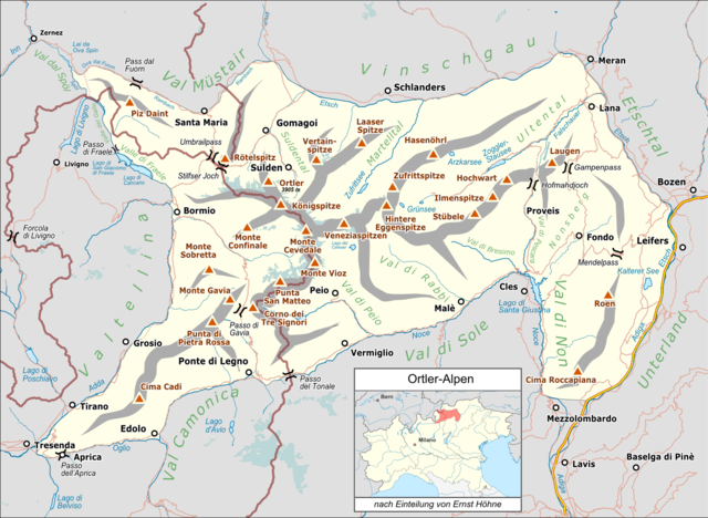
Deutsch: Lagekarte der Ortler-Alpen gemäß Ernst Höhne als Oberbegriff für Ortlergruppe, Sobretta-Gavia-Gruppe und Nonsberggruppe. |
|||||||||
| Date | ||||||||||
| Source |
Own work Map was created using:
|
|||||||||
| Creator |
|
|||||||||
| Permission (Reusing this file) |
Map data (c) OpenStreetMap (and) contributors, CC-BY-SA | |||||||||
| Geotemporal data | ||||||||||
| Bounding box |
|
|||||||||
| Georeferencing | ||||||||||
Licensing[edit]
.png&action=edit§ion=2)
I, the copyright holder of this work, hereby publish it under the following license:
This file is licensed under the Creative Commons Attribution 3.0 Unported license.
- You are free:
- to share – to copy, distribute and transmit the work
- to remix – to adapt the work
- Under the following conditions:
- attribution – You must give appropriate credit, provide a link to the license, and indicate if changes were made. You may do so in any reasonable manner, but not in any way that suggests the licensor endorses you or your use.
| This work is licensed under the Open Database License (summary). |
File history
Click on a date/time to view the file as it appeared at that time.
| Date/Time | Thumbnail | Dimensions | User | Comment | |
|---|---|---|---|---|---|
| current | 06:56, 19 May 2019 | | 1,447 × 1,057 (804 KB) | Pechristener (talk | contribs) | Doppelbeschriftung Gampenpass & Hofmahdjoch entfernt |
| 20:05, 28 November 2016 |  | 1,447 × 1,057 (807 KB) | Pechristener (talk | contribs) | Fehler beim Pass unten links entfernt | |
| 20:02, 28 November 2016 |  | 1,447 × 1,057 (807 KB) | Pechristener (talk | contribs) | {{Map |Description={{de|1=Lagekarte der {{w|Ortlergruppe||de}} nach der Einteilung von Ernst Höhne von 1993}} |Source ={{own}} Map was created using: *[http://www.openstreetmap.org/ Open Street Map] *[[:File:Italy_North_location_map.svg|It... |
You cannot overwrite this file.
File usage on Commons
The following 4 pages use this file:
File usage on other wikis
The following other wikis use this file:
- Usage on als.wikipedia.org
- Usage on de.wikipedia.org
.png&oldid=711746126)