File:Ordnance Survey Drawings - Dartmoor, Devon (OSD 22).jpg
Jump to navigation
Jump to search

Size of this preview: 707 × 599 pixels. Other resolutions: 283 × 240 pixels | 566 × 480 pixels | 906 × 768 pixels | 1,208 × 1,024 pixels | 2,416 × 2,048 pixels | 4,961 × 4,206 pixels.
Original file (4,961 × 4,206 pixels, file size: 4.25 MB, MIME type: image/jpeg)
Captions
Captions
Add a one-line explanation of what this file represents
| Dartmoor, Devon (OSD 22)
|
|||||
|---|---|---|---|---|---|
| Title |
Ordnance Survey Drawings: Dartmoor (OSD 22) |
.jpg) | |||
| Object type |
manuscript map |
||||
| Description |
 Centre of map shown on a map of England
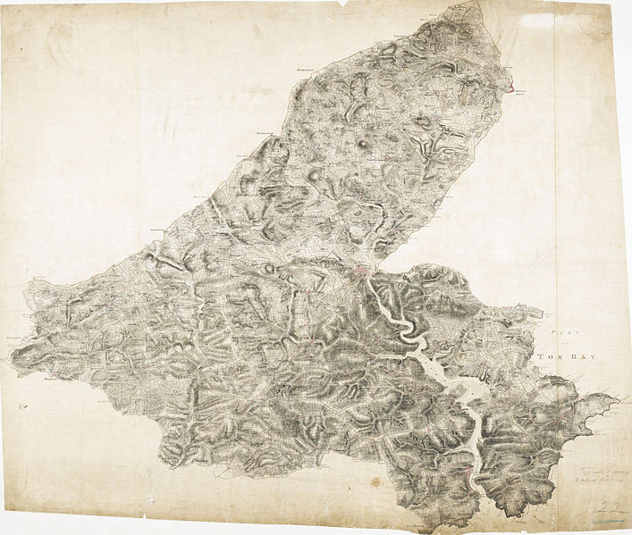
English: This drawing shows the estuary of the River Dart flowing into the English Channel. Numerous slate and limestone quarries surround the busy port at Dartmouth Harbour. Dartmouth Port also served the tin and copper mines on Dartmoor. Tan yards are marked at Totnes and Ashburton. Many cider orchards are noted. An Old Cross is drawn at Saint Petrocks (St Petrox) near the ruins of a castle across the estuary at Kiln Cove. Another castle appears at Totnes. The ancient earthworks at Woodbury Camp and many other early settlements are recorded in this area. While the authorship of this drawing is unknown, the elaborate hill shading and attention to communications routes conform to the military and cartographic standards employed by the West Country survey. The map is made up of three pieces. Its margins are trimmed and the drawing is in good condition..
This image has been georeferenced.
|
||||
| Language |
English |
||||
| Date | 1803 | ||||
| Medium | Pen and ink on paper | ||||
| Dimensions | height: 360 mm (14.17 in); width: 430 mm (16.92 in) | ||||
| Collection | |||||
| Accession number |
Maps OSD 22 |
||||
| Credit line | British Library | ||||
| Notes |
Scale 2 inches : 1 mile (1:31680). Please note that the British Library provides these digital files "as-is"; materials will not be rephotographed under this programme. If resupply of files is required, the requestor will be required to purchase them at the standard rate. |
||||
| References |
http://www.bl.uk/onlinegallery/onlineex/ordsurvdraw/d/002osd000000018u00015000.html (English) |
||||
| Source/Photographer |
|
||||
| Permission (Reusing this file) |
|
||||
| Other versions | |||||


_(St_Edwards_Crown).svg)
_cropped_to_show_Greenway.jpg)
.jpg¶ms=50.426942_N_-3.722047_E_)
.jpg¶ms=50.271081_N_-3.990198_E_)
.jpg¶ms=50.582802_N_-3.453896_E_)
.jpg¶ms=50.512751_N_-3.990198_E_)
.jpg¶ms=50.271081_N_-3.900158_E_)
.jpg¶ms=50.341132_N_-3.453896_E_)
.jpg¶ms=50.582802_N_-3.543936_E_)
File history
Click on a date/time to view the file as it appeared at that time.
| Date/Time | Thumbnail | Dimensions | User | Comment | |
|---|---|---|---|---|---|
| current | 19:40, 18 April 2013 | | 4,961 × 4,206 (4.25 MB) | Andrew Gray (talk | contribs) | {{Artwork |artist = |title = Ordnance Survey Drawings: Dartmoor, Devon (OSD 22) |description = This drawing shows the estuary of the River Dart flowing into the English Channel. Numerous slate and limestone quarries surround the busy port at Dart... |
You cannot overwrite this file.
File usage on Commons
The following 2 pages use this file:
File usage on other wikis
The following other wikis use this file:
- Usage on www.wikidata.org
.jpg&oldid=688968930)